U.S. Geological Survey Open-File Report 2012–1004
Sea-Floor Geology in Central Rhode Island Sound South of Sakonnet Point, Rhode Island
![]() Title |
List of Figures |
Conversion Factors |
Abstract |
Introduction |
Setting |
Methods |
Bathymetry |
Sediments |
Bottom Photography |
GIS Data Catalog |
Summary |
Acknowledgments |
References |
Contacts
Title |
List of Figures |
Conversion Factors |
Abstract |
Introduction |
Setting |
Methods |
Bathymetry |
Sediments |
Bottom Photography |
GIS Data Catalog |
Summary |
Acknowledgments |
References |
Contacts
 |
||
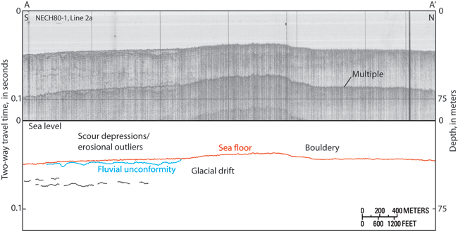
Figure 15. Seismic-reflection profile A-A', a section of line 2a obtained during cruise NECH80-1 on the research vessel Neecho in 1980 (McMullen and others, 2009), with interpretation. Line shows a fluvial unconformity in the south, under an area dominated by erosional outliers and scour depressions, and glacial drift elsewhere. Location of line shown in figure 12. |
||


