U.S. Geological Survey Open-File Report 2012-1157
Shallow Geology, Seafloor Texture, and Physiographic Zones of the Inner Continental Shelf from Nahant to Northern Cape Cod Bay, Massachusetts

|
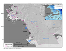
Purpose and ScopeThis report describes the glacial and postglacial geologic framework of the Massachusetts inner continental shelf between Nahant and northern Cape Cod Bay (fig. 1). We present interpretations that describe the distribution and texture of seafloor sediments, physiographic zones, surficial geology, and shallow stratigraphy of this inner-shelf region. Our interpretations are primarily based on geophysical data and bottom photographs, and samples published in U.S. Geological Survey (USGS) reports by Ackerman and others (2006), Butman and others (2007), Barnhardt and others (2010), and Andrews and others (2010) and in sample databases (Ford and Voss, 2010 McMullen and others, 2011) modified by Massachusetts Office of Coastal Zone Management (CZM). Interpretations and associated data are provided as geospatial data layers in Esri ArcGIS formats (Appendix 1– Geospatial Data). This research was part of a cooperative seafloor mapping program between the USGS and the CZM (http://woodshole.er.usgs.gov/project-pages/coastal_mass/). This cooperative fosters data collection and the production of interpretive geologic datasets that can be used by managers and scientists to delineate marine resources, assess environmental change, inventory marine habitats, and support research concerning sea-level change, sediment supply, and coastal evolution. The geologic framework and surficial sediment distribution of the coastal zone of Massachusetts is complex and difficult to map. Previous studies have defined the geology and texture of the seafloor in this region based on widely spaced geophysical tracklines or samples (Oldale and Bick, 1987; Oldale and O’Hara, 1990; Rendigs and Oldale, 1990; Knebel and others, 1993; Knebel and Circe, 1995; Rendigs and Knebel, 2002; Ford and Voss, 2010). Other mapping methods in homogenous, nonglaciated regions rely on contouring changes in grain size (Hollister, 1973), but the frequent substrate changes in this region occur over spatial scales that are smaller than a sampling grid can resolve. In this study, high-resolution geophysical datasets at full seafloor coverage, supplemented with sediment samples and bottom photographs, provide the basis for surficial to shallow stratigraphic geologic maps, high-resolution sediment texture maps, and physiographic zone delineations that were previously unfeasible because of a lack of high-quality, high-density seafloor mapping data.Geologic SettingThe geology of Boston Harbor, western Massachusetts Bay, and northern Cape Cod Bay was profoundly affected by the occupation and retreat of glacial ice sheets during the Pleistocene (Larson, 1982; Stone and Borns, 1986). Most of the glacial till and stratified drift overlying pre-Quaternary bedrock and coastal plain sediments were deposited by the Wisconsinan Laurentide ice sheet, which reached its maximum extent in eastern Massachusetts at Martha’s Vineyard and Nantucket about 20,000 to 24,000 years before present (BP; Uchupi and others, 1996; Oldale, 2001; Boothroyd and Sirkin, 2002). Sometime after 18,000 years BP, the Cape Cod Bay lobe of the ice sheet retreated sufficiently north of present-day Cape Cod to create an ice dam and supply sediment-laden meltwater to a pro-glacial lake that occupied the area of present-day Cape Cod Bay (Larson, 1982; Oldale, 1982, 1988), allowing extensive glaciolacustrine sediments to be deposited within the lake. The size of the lake fluctuated as the ice lobe receded from the Sandwich Moraine location and subsequently readvanced forming the Billingsgate Shoal Moraine along the southern margin of the bay (fig. 1; Larson, 1982; Oldale and O’Hara, 1984; Ridge, 2004). As the ice continued to retreat, the sea simultaneously submerged the isostatically depressed landscape, resulting in widespread deposition of glaciomarine sediments across northern Cape Cod Bay and Massachusetts Bay (Oldale and Bick, 1987; Oldale, 1988; Oldale and O’Hara, 1990). After the glaciers retreated north of Boston about 14,500 years BP, relative sea-level change became the dominant influence over regional evolution (Oldale and O’Hara, 1990; Oldale and others, 1993). Between about 14,000 and 12,000 years BP, relative sea level fell rapidly as the region isostatically rebounded and the subaerially exposed shelf was deeply incised by meltwater fluvial systems (Oldale and Bick, 1987; Oldale and O’Hara, 1990). After about 12,000 years BP, eustatic sea-level rise eventually outpaced waning isostatic rebound, causing the onset of the Holocene marine transgression that continues today (Oldale and O’Hara, 1990; Oldale and others, 1993). Low-lying valleys incised during the previous regression were partially filled by fluvial and estuarine deposits along the leading edge of the transgression, and coastal waves and currents effectively eroded, reworked, and redistributed sediments across the inner shelf seaward of the transgressing shoreline. Along the western margins of Cape Cod and Massachusetts Bays between Hull and Duxbury (fig. 1), inner-shelf sediments in water depths less than about 40 meters (m) have been extensively reworked and winnowed, resulting in seafloor textures much coarser than those in deep parts of Cape Cod Bay (Knebel and Circe, 1995; Knebel and others 1996). This zone is characterized by outcropping pre-Quaternary bedrock, rocky pavements consisting of boulders, cobbles, and gravel mixed with sand, and narrow channels and valleys filled with sand and gravel (Oldale and Bick, 1987; Oldale and O’Hara, 1990). Erosion of the inner shelf has provided the sand and gravel for building marsh-backed Holocene beaches along the adjacent coast. A transition to fine-grained sediment occurs in water depths between about 20 and 50 m in northern Cape Cod Bay. Variably thick sand ridges and shoals present in water depths less than about 30 m thin seaward, exposing underlying glacial drift and fluvial and estuarine channel fills at the seafloor in water depths between about 30 and 50 m. Deeper than about 50 m, Holocene marine muds blanket the seafloor (Oldale and O’Hara, 1990; Rendigs and Knebel, 2002; Uchupi and others, 2005). Unlike the unprotected, erosional inner shelf, Boston Harbor is a semi-enclosed basin that acts as a fine-grained sediment trap (Knebel and Circe, 1995). The Precambrian bedrock of the harbor basin crops out locally (Kaye, 1982; Rendigs and Oldale, 1990). Two glaciations have been identified in the sediments of Boston Harbor; the older glaciation is thought to be of Illinoian age and is represented by compacted till with cobbles and boulders, characterizing the drumlins of the Boston Harbor Islands (Newman and others, 1990; Oldale and Colman, 1992). The late Wisconsinan glacial sediments consist of till, outwash sand, gravel, and glacial-marine mud (Kaye, 1982; Oldale and Bick, 1987; Rendigs and Oldale, 1990). Marine transgression has reworked large areas of the harbor floor, eroded drumlins, constructed beaches and marshes, and stranded coarse lag deposits along the seafloor.Previous WorkMany authors have discussed the geology and geologic evolution of Cape Cod, the Islands, and the surrounding Massachusetts inner continental shelf, and findings from most have been synthesized by Uchupi and others (1996). Oldale and Bick (1987), Rendigs and Oldale (1990), and Oldale and O’Hara (1990) represent the most recent and extensive geologic framework studies for Massachusetts Bay, Boston Harbor, and Cape Cod Bay, respectively. These investigations are based on widely spaced boomer and 3.5-kilohertz (kHz) seismic-reflection profiles, sidescan sonar data, and vibracores, as well as observations from previous studies on the inner-shelf and adjacent mainland, and provide thorough descriptions of pre-Quaternary, glacial, and postglacial stratigraphy. In addition, Foster and Poppe (2003), Poppe and others (2006), and Uchupi and others (2005) provide stratigraphic interpretations for nearshore portions of eastern-most Cape Cod Bay based on boomer and chirp seismic-reflection profiles. Knebel and Circe (1995), Knebel and others (1996), and Rendigs and Knebel (2002) investigated seafloor sediments and sedimentary environments within Boston Harbor, Massachusetts Bay, and Cape Cod Bay, respectively. Based on reconnaissance sidescan sonar data and supplemental geologic and hydrodynamic data, these authors classified the seafloor by zones of erosion or nondeposition, sediment reworking, or deposition, and discussed their distributions in relation to regionally variable geologic and oceanographic conditions. Rendigs and Knebel (2002) also described the general distribution of sand, silt, and clay sediments in Cape Cod Bay by adding sediment sample analysis to sidescan sonar data. Subsequently, Poppe and others (2005) investigated seafloor sediments and sedimentary environments for a nearshore part of northeastern-most Cape Cod Bay utilizing multibeam bathymetry and backscatter, seafloor sediment samples, and bottom photographs. A comprehensive multidisciplinary investigation in Boston Harbor and Massachusetts Bay built on previous studies by incorporating sedimentary environments, acoustic data, geochemistry, numerical models, and observations to describe the processes influencing contaminated sediment transport (Bothner and Butman, 2007). Finally, Ford and Voss (2010) used more than 16,000 seafloor sediment samples to classify bottom type in Massachusetts State waters using Thiessen polygon analysis. |

![]() U.S. Department of the Interior |
U.S. Geological Survey
U.S. Department of the Interior |
U.S. Geological Survey
URL: http://pubsdata.usgs.gov/pubs/of/2012/1157/html/intro.html
Page Contact Information: GS Pubs Web Contact
Page Last Modified: Friday, 16-Aug-2013 11:52:37 EDT