Open-File Report 2012-1274
IntroductionEstuaries of the Pacific Northwest (PNW) provide critical habitat for fish, shellfish, and fowl that may be affected negatively as anthropogenic climate change leads to increasing air temperatures, sea level rise, shifts in the intensity and frequency of storms, changes in oceanic temperature and pH, and changes in the timing and volume of freshwater inputs (Ruggiero and others, 2010). To better understand and help partners prepare for these potential changes, the U.S. Geological Survey (USGS), through the National Climate Change and Wildlife Science Center, lead a multi-agency and inter-disciplinary investigation in collaboration with the U.S. Environmental Protection Agency (EPA) to model the range of ecological and physical effects of climate shifts in PNW estuaries. The primary objectives of the research project are to predict the effect of climate-related alterations on the distribution and abundance of two species of oysters, two species of seagrass, and tidal marsh habitat. In many PNW estuaries (including Coos, Yaquina, and Willapa Bays), oysters provide commercially important shellfish production and important ecosystem function, such as filtration of particulates from the water. Seagrasses provide critical habitats that serve as nurseries for estuarine fishes and crabs. Additionally, seagrasses and tidal marshes are important bird and juvenile salmon habitats. The interaction between freshwater flow into an estuary and seawater from the ocean creates a salinity regime that is vital to the existence of these critical habitats. As a part of the overall research effort, hydrological models were commissioned for four estuaries in Oregon and Washington coastal areas: South Slough of Coos Bay, Coquille River estuary, Willapa Bay, and Yaquina Bay (fig. 1). These estuaries were selected because they represent a range of estuary types, from a marine-dominated estuary (South Slough of Coos Bay) to a highly river-dominated estuary with a large watershed (Coquille River estuary), providing insight into how climatic drivers may alter different estuarine environments. Although the larger project is focused on estuaries, the models were developed for the entire area that drains to each estuary (that is, its watershed). Note that in two cases (Willapa Bay and Coos Bay South Slough), several small streams or rivers drain into a single estuary. In the models, we treated all such multi-tributary watersheds as single watersheds, and refer to them as such in this report. These hydrological models were developed to improve our understanding of how freshwater inflows to these estuaries may shift under climate change. Such shifts could be important, as they may cause changes in estuarine salinity, water quality (Scavia and others, 2002), the distribution of habitat and health aquatic species (Roessing and others, 2004; Levinton and others, 2011), and lead to increases in the spread of invasive species (Stachowicz and others, 2002; Winder and others, 2011). Different types of estuaries (marine- versus river-dominated) will have differing responses to changes in freshwater inflow. Salinity is an important factor in estuaries that influences the distribution of organisms as well as physical properties, such as stratification and mixing. Studies in other regions have demonstrated that climate change has the potential to influence estuarine salinity (Gibson and Najjar, 2000; Hilton and others, 2008). Climate change may influence the salinity distribution of estuaries, primarily through changes in freshwater inflow and rising sea level. The importance of each of these drivers on estuarine salinity will vary depending on season and location within an estuary. Declines in the freshwater inflow during the low-flow period may result in increased intrusion of saltwater up the estuary and increased water residence time, which can affect water quality. Such changes can influence the distribution of estuarine organisms. For example, Levinton and others (2011) show that changes in precipitation and resulting freshwater associated with climate change may result in increased mortality of oysters. Freshwater inflow to estuaries can influence other key water-quality conditions. For instance, dissolved oxygen (DO) is an important water-quality metric because of its effects on the well-being of resident and transitory estuarine organisms, particularly salmonids. The State of Oregon DO criterion for estuaries (6.5 mg/L) is based on a review of physiological requirements of biota, and is high compared to DO criteria for other estuaries (U.S. Environmental Protection Agency, 2003). A review of the DO criterion found that 6.5 mg/L may be difficult to achieve in Oregon estuaries during the summer because of natural conditions (Oregon Department of Environmental Quality, 1995). There have been occurrences of severe hypoxia on the inner continental shelf of Oregon (Grantham and others, 2004; Chan and others, 2008). This low-oxygen water is periodically advected into PNW estuaries (Brown and Power, 2011; Roegner and others, 2011). Declines in freshwater inflow during the low-flow period combined with sea level rise may result in increased intrusion of low-oxygen water into the estuaries, whereas in upriver parts of the estuaries, dissolved oxygen levels also may be influenced by climate change through increased stratification, reduced flushing, as well as temperature effects. Another important factor for water quality in PNW estuaries is bacterial impairment, which can affect commercial aquaculture and can be influenced by climate change. As an example, high concentrations of fecal coliform in the Tillamook estuary (indicator of fecal contamination) in autumn were preceded by dry conditions and high intensity rainfall (Sullivan and others, 2005). Climate projections for the PNW suggest that there may be decreases in summer precipitation and increases in winter precipitation. With this projected change in precipitation pattern, it is possible that there may be higher fecal coliform levels during autumn and early winter if there are sources in the watershed.
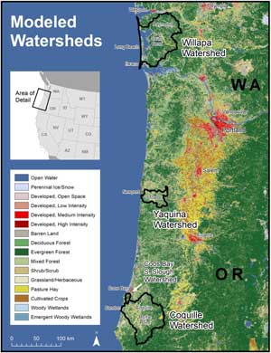
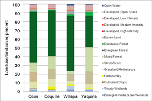
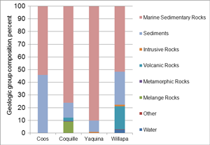
Study AreaFigure 1 shows locations of the watersheds draining to each of the four study estuaries, and table 1 gives basic facts about each watershed. Estuary type information is from Lee and Brown (2009), and other facts were derived from a 30-m USGS DEM (Digital Elevation Model). In the PNW region, rainfall is highly seasonal, with more than 75 percent of precipitation falling between October and March. Temperatures are mild in these coastal watersheds because they are near the ocean, so most precipitation falls as rain, even in winter. Figure 2 shows the Land Use-Land Cover (LULC) in each watershed according to the 2001 USGS National Land Cover Dataset (NLCD); evergreen forests are the predominant land cover class in all four watersheds, ranging from 36 to 60 percent of total area. All watersheds include some developed land, ranging from 5 to 10 percent of total area. Figure 3 shows the basic geological profile of each watershed. Throughout most of this region, marine sedimentary rocks, which have limited permeability, are the dominant type.
Coos Bay South Slough Estuary and WatershedThe Coos Bay South Slough watershed, the smallest of the four study watersheds with an area of 74.3 km2, is located on the southern Oregon Coast (fig. 1). The study area is the watershed draining only into the South Slough of Coos Bay; most of Coos Bay is not modeled. Coos County, which contains the bay, has an economy primarily based on fish, lumber, and shellfish harvests. Although there are no towns or cities within the South Slough watershed, the cities of Coos Bay (population 15,967) and North Bend (population 9,695) (U.S. Census Bureau, 2011), are located within 5 km of the study area on the northern shores of Coos Bay. In 1974, the Coos Bay South Slough was declared the nation’s first National Estuarine Research Reserve, and research on estuaries and how to restore them has been conducted there ever since (Oregon Coastal Management Program, 2011b). As shown in figure 3, this watershed has a greater percentage of sedimentary rocks than any of the other watersheds. There are no dams or diversions within the watershed (Falk and Robison, 2010). Coquille River Estuary and WatershedThe Coquille River estuary is at the mouth of the Coquille River, which drains a large watershed in southwest Oregon (fig. 1). As in Coos Bay, the primary economic foundations of the area are fishing and lumber, but dairy farming and other forms of agriculture also are common (Coquille Watershed Association, 2011). The 2,747.6 km2 watershed primarily is in Coos County, but small parts also are in Douglas and Curry Counties. The watershed contains three cities: Coquille (population 3,866), Myrtle Point (population 2,514), and Powers (population 689). It also includes parts of Bandon (population 3,066) near the Coquille River estuary (U.S. Census Bureau, 2011). Of the four study estuaries, the Coquille River estuary has the largest watershed and the strongest riverine influence. Nevertheless, saltwater penetrates the Coquille River, and tidal head has been observed as far as 41 mi upstream of the river’s mouth (Oregon Coastal Management Program, 2011a). The watershed contains two major dams. Major dams have a height greater than or equal to 50 ft (15 m), a normal storage capacity greater than or equal to 5,000 acre-feet (6,200,000 m3), or a maximum storage capacity greater than or equal to 25,000 acre-feet (31,000,000 m3). Combined, the two major dams have a normal storage capacity of 330 acre-feet (410,000 m3) (National Atlas of the United States, 2006). Willapa Bay Estuary and WatershedWillapa Bay is the second largest estuary on the Pacific Coast of the United States, and is home to the Willapa National Wildlife Refuge, which hosts more than 100,000 shorebirds during the spring migration (U.S. Fish and Wildlife Service, 2011). Willapa Bay’s 2,484.8 km2 watershed contains three cities: Raymond (population 7,892), South Bend (population 1,637), and Long Beach (population 1,392) (U.S. Census Bureau, 2011). The watershed also contains parts of the cities of Westport (population 6,661) and Ilwaco (population 936), as well as many unincorporated communities. There is one major dam in the watershed, with a normal storage of 846 acre-feet (1,000,000 m3) (National Atlas of the United States, 2006). As in all PNW coastal watersheds, timber plantations are a major part of the economy. Oyster production is especially important here (Wolf, 1993). Yaquina River Estuary and WatershedThe 676.6-km2 Yaquina watershed is drained by the Yaquina River and its major tributary, Big Elk Creek, which enter the Pacific Ocean at Yaquina Bay. The watershed contains parts of Newport (population 9,989), all of Toledo (population 3,465) (Oregon Department of Transportation, 2009; U.S. Census Bureau, 2011), and several other communities. Major economic activities include lumber, fishing, tourism, and agriculture (Ame, 2007). At the mouth of the river, Yaquina Bay supports an estuary with an area of 17.5 km2, which provides critical spawning, breeding, and nesting habitat for many species, including endangered and threatened salmonids (Bauer and others, 2011). The Yaquina estuary is a drowned river mouth estuary (Oregon Coastal Management Program, 2011c) and is tide-dominated (Lee and Brown, 2009). There are two major dams in the watershed (National Atlas of the United States, 2006). |
First posted February 28, 2013
For additional information contact: Part or all of this report is presented in Portable Document Format (PDF); the latest version of Adobe Reader or similar software is required to view it. Download the latest version of Adobe Reader, free of charge. |

![]() U.S. Department of the Interior |
U.S. Geological Survey
U.S. Department of the Interior |
U.S. Geological Survey
URL: http://pubsdata.usgs.gov/pubs/of/2012/1274/introduction.html
Page Contact Information: GS Pubs Web Contact
Page Last Modified: Thursday, 28-Feb-2013 19:44:14 EST