Skip past header information
USGS - science for a changing world

Open-File Report 2013-1020


High-Resolution Geophysical Data Collected Aboard the U.S. Geological Survey Research Vessel Rafael to Supplement Existing Datasets From Buzzards Bay and Vineyard Sound, Massachusetts


Introduction

Skip past contents information
Map showing the locations of the bathymetric survey areas (2011–013–FA, 2007–039–FA, and 2009–068–FA) around the eastern Elizabeth Islands and Martha's Vineyard, Massachusetts (outlined in red), and boomer tracklines from surveys 2010–100–FA and 2010–047–FA shown as dashed lines in Vineyard Sound and Buzzards Bay. Is., Island; UTM, Universal Transverse Mercator.

Figure 1. Map showing the locations of the bathymetric survey areas (2011–013–FA, 2007–039–FA, and 2009–068–FA) around the eastern Elizabeth Islands and Martha's Vineyard, Massachusetts (outlined in red), and boomer tracklines from surveys 2010–100–FA and 2010–047–FA shown as dashed lines in Vineyard Sound and Buzzards Bay. Is., Island; UTM, Universal Transverse Mercator.

Map showing bathymetric survey areas (2011–013–FA, 2007–039–FA, and 2009–068–FA) discussed in this report along with areas of other U.S. Geological Survey (USGS) and National Oceanic and Atmospheric Administration (NOAA) surveys in Buzzards Bay and Vineyard Sound, Massachusetts. Areas surveyed in this study are shown in yellow. This small-boat survey was completed to fill gaps in the shallow-water areas around the eastern Elizabeth Islands and Martha's Vineyard, Massachusetts. Is., Island. See the “additional sample and geophysical data” section under “Data Collection and Processing” for more information regarding the other USGS and NOAA surveys shown in this map.

Figure 2. Map showing bathymetric survey areas (2011–013–FA, 2007–039–FA, and 2009–068–FA) discussed in this report along with areas of other U.S. Geological Survey (USGS) and National Oceanic and Atmospheric Administration (NOAA) surveys in Buzzards Bay and Vineyard Sound, Massachusetts. Areas surveyed in this study are shown in yellow. This small-boat survey was completed to fill gaps in the shallow-water areas around the eastern Elizabeth Islands and Martha's Vineyard, Massachusetts. Is., Island. See the “additional sample and geophysical data” section under “Data Collection and Processing” for more information regarding the other USGS and NOAA surveys shown in this map.

Photograph showing the configuration of acquisition equipment on the U.S. Geological Survey research vessel Rafael. The real-time kinematic (RTK) global positioning system (GPS) antennae and the swath interferometric-sonar head are located off the bow, and the Klein 3000 sonar system and the Knudsen chirp bottom profiler are deployed from the port and starboard sides, respectively. Photograph by David Foster.

Figure 3. Photograph showing the configuration of acquisition equipment on the U.S. Geological Survey research vessel Rafael. The real-time kinematic (RTK) global positioning system (GPS) antennae and the swath interferometric-sonar head are located off the bow, and the Klein 3000 sonar system and the Knudsen chirp bottom profiler are deployed from the port and starboard sides, respectively. Photograph by David Foster.

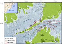
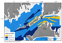
This report contains high-resolution geophysical data from approximately 70 square-kilometers (km2) of the sea floor surrounding the eastern Elizabeth Islands and northern coast of Martha's Vineyard, and on sand shoals in Vineyard Sound, Massachusetts (fig. 1). Adding to the series of geophysical data reports (Barnhardt and others, 2006, 2009, 2010; Ackerman and others, 2006; Andrews and others, 2010, 2012; Pendleton and others, 2012; Turecek and others, 2012) published through a cooperative mapping program (http://woodshole.er.usgs.gov/project-pages/coastal_mass/) between the U.S. Geological Survey (USGS) and the Massachusetts Office of Coastal Zone Management (CZM), this collection of relatively small surveys was conducted to supplement seismic-survey data and to fill gaps among existing National Oceanic and Atmospheric Administration (NOAA) hydrographic surveys and other USGS geophysical surveys of Vineyard Sound and Buzzards Bay (fig. 2).


This report contains processed bathymetry, acoustic-backscatter intensity, seismic-reflection, sound velocity, and navigation data along with a description of the collection and processing methods used during USGS surveys 2011–013–FA, 2010–100–FA, 2010–047–FA, 2009–068–FA and 2007–039–FA aboard USGS research vessel (RV) Rafael (fig. 3). Products derived from these data are integrated within a geographic information system (GIS) and are used to facilitate management decisions and form the foundation for interpretive geological maps of the region. The long-term goals of this mapping program are to provide a framework for scientific research and to develop geologic information for the management of coastal and marine resources. High-resolution spatial data and detailed maps of sea-floor geology are essential information for managers responsible for protecting fish habitats and delineating marine resources and for researchers assessing environmental changes caused by natural or human impacts.

Vineyard Sound is between Martha's Vineyard and the Elizabeth Islands, which trail off the southwestern corner of Cape Cod at Woods Hole, Massachusetts, and separate Vineyard Sound from Buzzards Bay (fig. 1). The Elizabeth Islands are composed of remnants of the Buzzards Bay Moraine that formed about 20 thousand years before present during the waning stage of the last glaciation (Oldale, 1982; Balco, 2011). As sea-level rose throughout the Holocene following deglaciation, parts of the Buzzards Bay Moraine became submerged, isolating the Elizabeth Islands from Cape Cod (Mather and others, 1942; Larson, 1982; Oldale and O’Hara, 1984; Uchupi and others, 1996). The nearshore surveyed areas off the Elizabeth Islands outline the surficial extent of the original moraine deposits and changeover to modern marine and estuarine deposits as tracklines move offshore into Buzzards Bay. In Vineyard Sound, water depths increase quickly off the Elizabeth Islands, where deep tidal channels scour into glacial deposits. The sand shoals surveyed in Vineyard Sound, which rise as much as 25 meters (m) above the surrounding channels, are associated with ice-contact deposits and are usually covered in bedforms. The largest sand bodies, such as Middle Ground, Hedge Fence, and L'Hommedieu, have persisted in approximately their present locations since the first nautical charts of the area were made in the late 1700s. These shoals demonstrate the role that strong currents and marine processes have played in reworking glacial sediments since the Holocene marine transgression.

Accessibility FOIA Privacy Policies and Notices

Take Pride in America logo USA.gov logo U.S. Department of the Interior | U.S. Geological Survey
URL: http://pubsdata.usgs.gov/pubs/of/2013/1020/html/ofr2013-1020_intro.html
Page Contact Information: GS Pubs Web Contact
Page Last Modified: Wednesday, 12-Mar-2014 17:12:35 EDT