Open-File Report 2014-1224
![]() Title |
List of Figures |
Conversion Factors |
Abstract |
Introduction |
Setting |
Methods |
Bathymetry |
Sidescan Sonar |
Sediments |
Bottom Photography |
Interpretation |
GIS Data Catalog |
Summary |
Acknowledgments |
References |
Contacts |
Index
Title |
List of Figures |
Conversion Factors |
Abstract |
Introduction |
Setting |
Methods |
Bathymetry |
Sidescan Sonar |
Sediments |
Bottom Photography |
Interpretation |
GIS Data Catalog |
Summary |
Acknowledgments |
References |
Contacts |
Index
 |
||
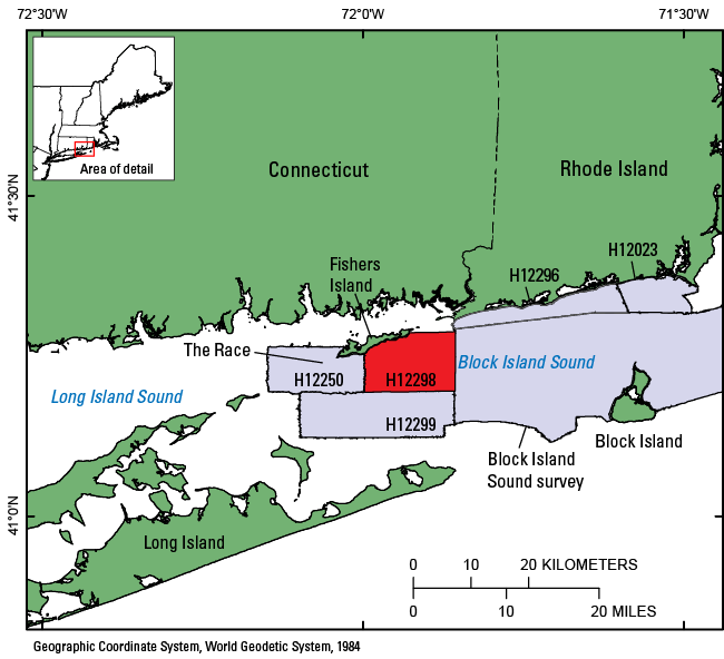
Figure 1. Map showing the location of National Oceanic and Atmospheric Administration (NOAA) survey H12298 (red-shaded polygon) offshore of Fishers Island, New York. Also shown are other NOAA surveys (gray-shaded polygons) that have been interpreted in this series in Rhode Island and Block Island Sounds, including H12299 (McMullen, Poppe, Danforth, and others, 2014); H12296 (McMullen, Poppe, Ackerman, and others, 2014); H12023 (McMullen and others, 2013); Block Island Sound survey, a combination of surveys H12009, H12010, H12011, H12015, H12033, H12137, and H12139 (Poppe and others, 2012); and H12250 (Poppe and others, 2007). |
||

![]() U.S. Department of the Interior |
U.S. Geological Survey
U.S. Department of the Interior |
U.S. Geological Survey
URL: http://pubsdata.usgs.gov/pubs/of/2014/1224/html/ofr2014-1224-fig1.html
Page Contact Information: GS Pubs Web Contact
Page Last Modified: Wednesday, 07-Dec-2016 20:06:40 EST
