Open-File Report 2014-1224
![]() Title |
List of Figures |
Conversion Factors |
Abstract |
Introduction |
Setting |
Methods |
Bathymetry |
Sidescan Sonar |
Sediments |
Bottom Photography |
Interpretation |
GIS Data Catalog |
Summary |
Acknowledgments |
References |
Contacts |
Index
Title |
List of Figures |
Conversion Factors |
Abstract |
Introduction |
Setting |
Methods |
Bathymetry |
Sidescan Sonar |
Sediments |
Bottom Photography |
Interpretation |
GIS Data Catalog |
Summary |
Acknowledgments |
References |
Contacts |
Index
 |
||
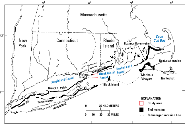
Figure 2. Map of end moraines (black-shaded polygons) and submerged ridges associated with the offshore extensions of these moraines (dashed lines) in southern New York and New England (modified from Gustavson and Boothroyd, 1987) along with the study area (red-outlined polygon). The Ronkonkoma-Block Island-Nantucket terminal moraine represents the maximum advance of the Laurentide Ice Sheet about 25,500 to 28,100 years ago, whereas the Harbor Hill-Roanoke Point-Charlestown-Buzzards Bay end moraine represents a retreated ice-sheet position from about 20,400 to 22,400 years ago (Balco, 2011). |
||

![]() U.S. Department of the Interior |
U.S. Geological Survey
U.S. Department of the Interior |
U.S. Geological Survey
URL: http://pubsdata.usgs.gov/pubs/of/2014/1224/html/ofr2014-1224-fig2.html
Page Contact Information: GS Pubs Web Contact
Page Last Modified: Wednesday, 07-Dec-2016 20:06:46 EST
