Open-File Report 2014-1224
![]() Title |
List of Figures |
Conversion Factors |
Abstract |
Introduction |
Setting |
Methods |
Bathymetry |
Sidescan Sonar |
Sediments |
Bottom Photography |
Interpretation |
GIS Data Catalog |
Summary |
Acknowledgments |
References |
Contacts |
Index
Title |
List of Figures |
Conversion Factors |
Abstract |
Introduction |
Setting |
Methods |
Bathymetry |
Sidescan Sonar |
Sediments |
Bottom Photography |
Interpretation |
GIS Data Catalog |
Summary |
Acknowledgments |
References |
Contacts |
Index
 |
||
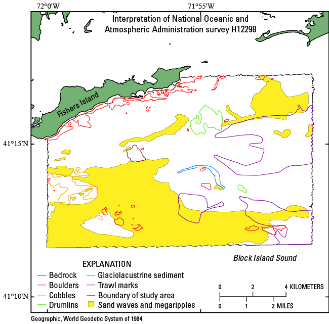
Figure 28. Interpretation of the sea floor in the National Oceanic and Atmospheric Administration survey H12298 study area. Features include bedrock, boulders, cobbles, drumlins, glaciolacustrine sediment, trawl marks, and sand waves and megaripples. Areas of the study area that are not outlined appear generally featureless in the multibeam bathymetry data and are interpreted to be modern marine sediments. Interpretations are based on multibeam-bathymetry, sidescan-sonar, sediment, and photographic data collected in the study area. |
||

![]() U.S. Department of the Interior |
U.S. Geological Survey
U.S. Department of the Interior |
U.S. Geological Survey
URL: http://pubsdata.usgs.gov/pubs/of/2014/1224/html/ofr2014-1224-fig28.html
Page Contact Information: GS Pubs Web Contact
Page Last Modified: Wednesday, 07-Dec-2016 20:06:51 EST
