USGS - science for a changing world

Open-File Report 2015–1055

Effects of Proposed Sediment Borrow Pits on Nearshore Wave Climate and Longshore Sediment Transport Rate Along Breton Island, Louisiana


Appendix 4. Analysis of Borrow Pit 3

Skip past contents information

Introduction

Click on figures for larger images.
Thumbnail image for Figure A4-1. Maps showing (A) the location of Breton Island in the Gulf of Mexico, the G1, G2, and G3 numerical model domains, and the three National Data Buoy Center (NDBC) buoys (42040, 42012, and 42007) used in model scenario development and assessment, and (B) the elevations and spatial extent of the G3 model domain, showing the G4 domain as well as the extent of three proposed borrow pits considered in the wave modeling study. The channel running northeast of Breton Island is the Mississippi River Gulf Outlet (MRGO).
Figure A4-1. Maps showing (A) the location of Breton Island in the Gulf of Mexico, the G1, G2, and G3 numerical model domains, and the three National Data Buoy Center (NDBC) buoys (42040, 42012, and 42007) used in model scenario development and assessment, and (B) the elevations and spatial extent of the G3 model domain, showing the G4 domain as well as the extent of three proposed borrow pits considered in the wave modeling study. The channel running northeast of Breton Island is the Mississippi River Gulf Outlet (MRGO).
Thumbnail image for Figure A4-2. Weighted average significant wave height for (A) bathymetry including borrow pit 3 (outlined in white) and (B) change from the baseline case. The average is created from the output of individual scenarios, weighted by their percentage occurrence over the time period December 1995 through December 2013 (fig. 2). Borrow pit 3 creates a shadowing effect originating from the corners.
Figure A4-2. Weighted average significant wave height for (A) bathymetry including borrow pit 3 (outlined in white) and (B) change from the baseline case. The average is created from the output of individual scenarios, weighted by their percentage occurrence over the time period December 1995 through December 2013 (fig. 2). Borrow pit 3 creates a shadowing effect originating from the corners.
Thumbnail image for Figure A4-3. For 135 locations (A, black line) along Breton Island (0 m contour shown in green), average longshore transport rate (B, LSTR) calculated by weighting each of the 116 individual scenario results by its frequency of occurrence in the wave climatology (fig. 2). The change in magnitude of the weighted average longshore transport rate (C) with the addition of the pits is less than 30 percent of the baseline values, and the overall pattern in transport is the same (B).
Figure A4-3. For 135 locations (A, black line) along Breton Island (0 m contour shown in green), average longshore transport rate (B, LSTR) calculated by weighting each of the 116 individual scenario results by its frequency of occurrence in the wave climatology (fig. 2). The change in magnitude of the weighted average longshore transport rate (C) with the addition of the pits is less than 30 percent of the baseline values, and the overall pattern in transport is the same (B).
Thumbnail image for Figure A4-4. Gradient of average longshore transport rate (B, LSTR) constructed from the longshore transport calculated using wave conditions at 135 locations (A, black line) along Breton Island (0 m contour shown in green) for each of the 116 individual scenario results (e.g., fig. 15 for the no pit case) by weighting each scenario by its frequency of occurrence in the wave climatology (fig. 2). The change in magnitude of the gradient of the LSTR (C) with the addition of the pits is an order of magnitude less than the baseline values, and the overall pattern in transport is the same (B). Positive values in (C) indicate more accretion or less erosion, negative values indicate less accretion or more erosion.
Figure A4-4. Gradient of average longshore transport rate (B, LSTR) constructed from the longshore transport calculated using wave conditions at 135 locations (A, black line) along Breton Island (0 m contour shown in green) for each of the 116 individual scenario results (e.g., fig. 15 for the no pit case) by weighting each scenario by its frequency of occurrence in the wave climatology (fig. 2). The change in magnitude of the gradient of the LSTR (C) with the addition of the pits is an order of magnitude less than the baseline values, and the overall pattern in transport is the same (B). Positive values in (C) indicate more accretion or less erosion, negative values indicate less accretion or more erosion.

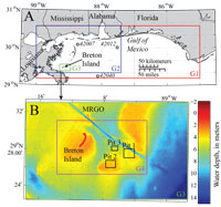
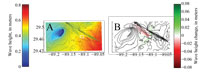
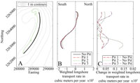
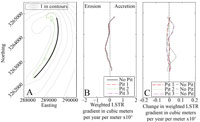
After the analysis of the two borrow pits described in this report was completed, a third borrow site was identified as a potential location to obtain sediment for the Breton Island restoration project. The same techniques (see Methods) were applied to analyze the impacts of this third site (hereafter referred to as borrow pit 3), and the results are presented here. The model output from borrow pit 3 can be found in Mickey and others (2017). The location of borrow pit 3 is shown in figure A4-1, and its characteristics are described in table A4-1.

Results: Effects of Borrow Pits on Nearshore Wave Climate and Longshore Transport

The change in weighted average wave height for borrow pit 3 was less than 10 cm at the location of maximum difference (fig. A4-2), or 8 percent of the baseline case.

Scenario-weighted longshore transport rate (LSTR) with the addition of borrow pit 3 was similar to the baseline LSTR, with a maximum difference of 0.08 x 10⁵ m3/year (0.0002 m3/s). This magnitude of change is less than 35 percent of the baseline LSTR (fig. A4-3). The maximum change in the gradient of LSTR with the addition of borrow pit 3 was 0.04 x 10³ m3/year, approximately 35 percent of the baseline (fig. A4-4).

Conclusions

An analysis of the proposed borrow pit 3 was conducted following the same methodology used for the previous two borrow pits described in the main body of this report. The change in weighted-average wave height with the addition of borrow pit 3 was less than 10 cm and greatest near the proposed site (fig. A4-1). Changes to the LSTR and its gradient were less than 35 percent of the baseline case, with the largest changes toward the northern end of Breton Island (figs. A4-3, A4-4).

Accessibility FOIA Privacy Policies and Notices

Take Pride in America logo USA.gov logo U.S. Department of the Interior | U.S. Geological Survey
URL: http://pubsdata.usgs.gov/pubs/of/2015/1055/ofr2015-1055_appendix4.html
Page Contact Information: GS Pubs Web Contact
Page Last Modified: Monday, 28-Aug-2017 16:46:05 EDT