Open-File Report 2015-1149
|
|
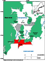
IntroductionThe U.S. Geological Survey (USGS), in cooperation with the National Oceanic and Atmospheric Administration (NOAA), is mapping the sea floor along the northeastern coast of the United States. This report covers a 28.7-square-kilometer area of southern Narragansett Bay, Rhode Island (fig. 1). In 2011, NOAA collected multibeam echosounder (MBES) data in this area to update hydrographic charts. In 2014, USGS collected sediment samples, still photographs, and video imagery from the sea floor in order to verify the bathymetric data. The purpose of this report is to use the compilation of these data to interpret and delineate sea-floor features and sedimentary environments, as well as to release the bathymetric, sediment, and photographic data collected in southern Narragansett Bay. These interpretations provide base maps for a variety of coastal research needs including resource management and studies of contaminants, benthic ecology, and sediment transport. |

![]() U.S. Department of the Interior |
U.S. Geological Survey
U.S. Department of the Interior |
U.S. Geological Survey
URL: http://pubsdata.usgs.gov/pubs/of/2015/1149/html/ofr20151149_intro.html
Page Contact Information: GS Pubs Web Contact
Page Last Modified: Wednesday, 07-Dec-2016 21:44:10 EST