Open-File Report 2015-1149
|
|
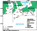
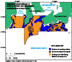
SedimentsSediment DistributionSediments in the study area range in size from boulders and gravel to sandy silt (fig. 15). Rocky areas, with bedrock, boulders, and (or) gravel, were found near the shoreline and throughout much of the eastern part of the study area. Gravelly sediment was found in the channel off Ragged Point. Sand covers much of the relatively flat areas of the sea floor and is generally finer in West Passage than in East Passage and south of Aquidneck Island. Sandy silt is located in a cove off Conanicut Island and in some deeper areas south of the island. The sediment samples collected during cruise 2014-046-FA are generally similar to those in nearby areas from the historically collected data (Poppe and others, 2003). Sedimentary EnvironmentsThree sedimentary environments were found in the study area: those characterized by the processes of erosion or nondeposition, coarse-grained bedload transport, and sorting and reworking (fig. 16). High-energy environments of erosion or nondeposition dominate on the sea floor where wave energy is strong, such as in the shallows along shorelines and on top of isolated bathymetric highs, and where tidal currents are constricted, causing scour, such as along the thalweg of East Passage and throughout much of the eastern part of the study area. Coarse-grained bedload transport occurs where sand waves are present on the sea floor, in several patches in East and West Passages. Lower energy environments of sorting and reworking can be found in areas protected from strong wave and tidal currents. These areas include the middle of West Passage, those parts of East Passage away from shorelines and the main channel, the deeper areas offshore, and the eastern part of the study area between rocky outcrops where the sea floor is sandy. Sediment DataThe sediment grain-size dataset provided in this report contains information on the collection, description, and texture of sediments at 21 stations in the study area. The sea floor was sampled at only 15 of the stations because rocky outcrops prevented samples from being obtained at the other stations. Stations that were not sampled were visually classified on the basis of video and still photography obtained at the stations. These stations have no-data values (-9999) in the textural and statistical sections of the sediment dataset. The basic structure of the dataset is laid out in a matrix, in which rows represent individual samples and columns (fields) contain sample- and station-specific information. This matrix consists of 42 fields that are defined in the “Data Dictionary” section. In the Geographic Information System Data Catalog section of this report, a .zip file contains the sediment data in three formats (a shapefile, a Microsoft Excel spreadsheet, and a comma-delimited ASCII text file) along with metadata. Data DictionaryAn integral part of any database is the dictionary that explains the structure and content. It contains a list of the fields and definitions of parameters measured. Data utilization is facilitated by reference to this compilation because it defines abbreviations and lists field names. LABNO - Unique sample identifier assigned in the laboratory STATIONID - Sample name or number assigned in the field PROJECT - Project under which samples were taken or data were generated CRUISEID - Name or number of cruise on which the sample was collected or station was occupied PRINCIPAL - Name of the principal investigator LATITUDE - Latitude in decimal degrees (north latitudes are positive values) LONGITUDE - Longitude in decimal degrees (west longitudes are negative values) DEPTH_M - Depth of water overlying sediment at the time of sampling, measured by a hull-mounted fathometer, corrected for draft, but not corrected for tides, in meters T_DEPTH - Top depth of the sample below the sediment-water interface, in centimeters B_DEPTH - Bottom depth of the sample below the sediment-water interface, in centimeters DEVICE - Device used to collect the sample MONTH - Number of calendar month during which the sample was collected DAY - Calendar day on which the sample was collected YEAR - Calendar year during which the sample was collected WEIGHT - Dry weight of sample, in grams ZGRAVEL - Gravel content in percentage of dry weight of the sample (particles with nominal diameters greater than 2 mm; -1 phi and larger) ZSAND - Sand content in percentage of dry weight of the sample (particles with nominal diameters less than 2 mm but greater than or equal to 0.0625 mm; 0 through 4 phi, inclusive) ZSILT - Silt content in percentage of dry weight of the sample (particles with nominal diameters less than 0.0625 mm but greater than or equal to 0.004 mm; 5 through 8 phi, inclusive) ZCLAY - Clay content in percentage of dry weight of the sample (particles with nominal diameters less than 0.004 mm; 9 phi and smaller) SEDCLASS - Sediment description based on a rigorous definition (Shepard, 1954; Schlee, 1973; Poppe and others, 2004)
MEDIAN - Middle point in the grain-size distribution, in phi units MEAN - Average value in the grain-size distribution, in phi units STDDEV - Standard deviation (root mean square of the deviations) of the grain-size distribution, in phi units (that is, sorting) SKEWNESS - Deviation from symmetrical form of the grain-size distribution KURTOSIS - Degree of curvature near the mode of the grain-size distribution PHI_11 - Weight percentage of the sample in the 11-phi fraction (nominal diameter of particles greater than or equal to 0.0005 mm but less than 0.001 mm); fine clay PHI_10 - Weight percentage of the sample in the 10-phi fraction (nominal diameter of particles greater than or equal to 0.001 mm but less than 0.002 mm); medium clay PHI_9 - Weight percentage of the sample in the 9-phi fraction (nominal diameter of particles greater than or equal to 0.002 mm but less than 0.004 mm); coarse clay PHI_8 - Weight percentage of the sample in the 8-phi fraction (nominal diameter of particles greater than or equal to 0.004 mm but less than 0.008 mm); very fine silt PHI_7 - Weight percentage of the sample in the 7-phi fraction (nominal diameter of particles greater than or equal to 0.008 mm but less than 0.016 mm); fine silt PHI_6 - Weight percentage of the sample in the 6-phi fraction (nominal diameter of particles greater than or equal to 0.016 mm but less than 0.031 mm); medium silt PHI_5 - Weight percentage of the sample in the 5-phi fraction (nominal diameter of particles greater than or equal to 0.031 mm but less than 0.0625 mm); coarse silt PHI_4 - Weight percentage of the sample in the 4-phi fraction (nominal diameter of particles greater than or equal to 0.0625 mm but less than 0.125 mm); very fine sand PHI_3 - Weight percentage of the sample in the 3-phi fraction (nominal diameter of particles greater than or equal to 0.125 mm but less than 0.25 mm); fine sand PHI_2 - Weight percentage of the sample in the 2-phi fraction (nominal diameter of particles greater than or equal to 0.25 mm but less than 0.5 mm); medium sand PHI_1 - Weight percentage of the sample in the 1-phi fraction (nominal diameter of particles greater than or equal to 0.5 mm but less than 1 mm); coarse sand PHI_0 - Weight percentage of the sample in the 0-phi fraction (nominal diameter of particles greater than or equal to 1 mm but less than 2 mm); very coarse sand PHIM1 - Weight percentage of the sample in the -1-phi fraction (nominal diameter of particles greater than or equal to 2 mm but less than 4 mm); very fine pebbles (granules) PHIM2 - Weight percentage of the sample in the -2-phi fraction (nominal diameter of particles greater than or equal to 4 mm but less than 8 mm); fine pebbles PHIM3 - Weight percentage of the sample in the -3-phi fraction (nominal diameter of particles greater than or equal to 8 mm but less than 16 mm); medium pebbles PHIM4 - Weight percentage of the sample in the -4-phi fraction (nominal diameter of particles greater than or equal to 16 mm but less than 32 mm); coarse pebbles PHIM5 - Weight percentage of the sample in the -5-phi fraction (nominal diameter of particles greater than or equal to 32 mm); very coarse pebbles to boulders |

![]() U.S. Department of the Interior |
U.S. Geological Survey
U.S. Department of the Interior |
U.S. Geological Survey
URL: http://pubsdata.usgs.gov/pubs/of/2015/1149/html/ofr20151149_seds.html
Page Contact Information: GS Pubs Web Contact
Page Last Modified: Wednesday, 07-Dec-2016 21:44:13 EST