Open-File Report 2015-1149
|
|
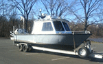
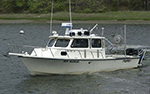
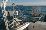
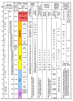
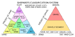
MethodsMBES data were collected by the National Oceanic and Atmospheric Administration (NOAA) during survey H12324 between June and September 2011. Data were collected aboard the 30-foot NOAA survey vessel S3002 (fig. 2), using a hull-mounted Kongsberg Simrad EM3002. This system has a 130-degree swath width and a maximum ping rate of 40 hertz (Hz). Positioning was determined by differential global positioning system (DGPS), which received corrections from Acushnet, Massachusetts. Water levels are referenced to mean lower low water and were tide-corrected by using National Water Level Observation Network stations in Newport and Quonset Point, R.I. MBES data were processed (for example, water levels were tide-corrected and soundings and attitude data were filtered) by using Computer Aided Resource Information System (CARIS) Hydrographic Information Processing System (HIPS) software. Bathymetric attributed grid (BAG) files were made available to the public on the National Geophysical Data Center (NGDC) Web site. These BAG files were downloaded and used to make geospatial tagged image file format files (GeoTIFFs) and Esri ArcRaster grids using Blue Marble Geographics Global Mapper and Esri ArcGIS software. More detailed information on the data acquisition and processing for this survey is provided in National Oceanic and Atmospheric Administration (2011a, b) and in the metadata files in the Geographic Information System Data Catalog section of this report. The small Seabed Observation and Sampling System (SEABOSS) was used at 21 target sampling sites to collect video, still photographs, and physical sediment samples of the sea floor within the study area during USGS cruise 2014-046-FA (September 2014) aboard the research vessel (RV) Rafael (fig. 3). The USGS’s SEABOSS (fig. 4) contains a modified Van Veen grab sampler with still and video cameras integrated into an approximately 1-m x 1-m steel frame. At a typical sampling site, video is collected along a transect of the sea floor as the system drifts for several minutes; scientists aboard the research vessel observe the video in real-time and manually trigger the still digital camera to take bottom photographs and finally the system is lowered to the sea floor to take a sediment sample usually at the end of the transect. Six stations do not have samples, because the sea floor was too rocky for sampling as determined from the real-time video feed. Upon recovery of the SEABOSS on the deck of the RV Rafael, samples were collected from the top 2 centimeters of the Van Veen grab. These samples were later analyzed in the USGS Woods Hole Coastal and Marine Science Center’s Sediment Lab according to the methods of Poppe and others (2014). The coarse fractions (sand and gravel; diameters equal to or greater than 0.0625 millimeters [mm]) of samples were sieved and the fine fractions (silt and clay; diameters less than 0.0625 mm) were analyzed by using a Beckman Coulter Multisizer 3. Gravel-sized shells were removed from the samples because they are not generally considered to be representative of the sedimentary environment; shells often form in situ and they do not behave in the same hydraulic manner as similarly sized sediment. Results of the sediment-sample analyses are described on the basis of nomenclature of Wentworth (1922; fig. 5) and modified size classifications of Shepard (1954; fig. 6). To facilitate interpretations of the distributions of sea-floor features and sedimentary environments, data contained in this report were supplemented by sediment data from a compilation of earlier studies (Poppe and others, 2003). The interpretations of sea-floor features and sedimentary environments presented herein are based on bathymetric data and on data from the sediment-sampling and bottom-photography stations. For the purposes of this report, bedforms are defined by morphology and amplitude. Sand waves are higher than 1 m; megaripples are 0.2 to 1 m high; ripples are less than 0.2 m high (Ashley, 1990). The bathymetric grids and imagery released in this report should not be used for navigation. |

![]() U.S. Department of the Interior |
U.S. Geological Survey
U.S. Department of the Interior |
U.S. Geological Survey
URL: http://pubsdata.usgs.gov/pubs/of/2015/1149/html/ofr20151149_methods.html
Page Contact Information: GS Pubs Web Contact
Page Last Modified: Wednesday, 07-Dec-2016 21:44:11 EST