Open-File Report 2015-1149
|
|
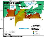
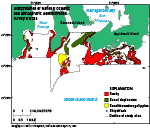
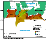
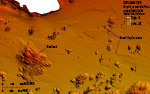
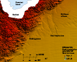
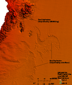
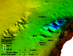
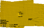
BathymetryWater depths in the study area range from about 1 m along shorelines to 62 m in a channel off Ragged Point on the southwestern part of Aquidneck Island (fig. 7). Several features are present on the sea floor in the study area including rocky areas, scour depressions, sand waves and megaripples, and shipwrecks (fig. 8). Much of the sea floor lacks these geologic features and has a smooth appearance within the resolution of the bathymetry data. These featureless areas are predominantly in the middle of West Passage and in moderate depths of East Passage (approximately 10 to 30 m water depth). Rocky areas of the sea floor tend to be along the coast and in the eastern part of the study area where bedrock and boulders cover much of the sea floor (figs. 9 and 10). Rocky patches were also found south of Conanicut Island in the middle of the approach to East Passage. Bedding planes in the bedrock are visible in the bathymetric imagery (fig. 11) and have strikes similar to those mapped onshore (Jamestown Visitor Information, 2003), indicating the rocky areas are likely underwater exposures of bedrock. Several areas of scoured sea floor are visible in the bathymetric data. The deeper parts of East Passage have been scoured by strong tidal currents that flow into and out of Narragansett Bay (Kincaid and others, 2003; White and White, 2008). Patches of depressions are visible near exposed bedrock and boulders along some coastlines, especially in the eastern part of the study area, south of Aquidneck Island (fig. 10). These depressions are about 0.5 m deep, and have flat floors and steep sides. They are similar to other scour depressions observed in Block Island and Rhode Island Sounds formed from the interaction with the sea floor of wave setup and return flow, wave and tidal currents flowing through constricted areas, and storm-wave-induced currents (McMullen, Poppe, Twomey, and others, 2007; Oakley and others, 2009; McMullen and others, 2011; Poppe and others, 2011; McMullen and others, 2012; Poppe and others, 2012; McMullen and others, 2013; McMullen and others, 2015). The scour depressions adjacent to the southeastern coast of Conanicut Island trend normal to the shore (fig. 11) and are likely similar to those discussed by Oakley and others (2009), which are thought to be formed and maintained by downwelling of return flow from storm waves. Most of the scour depressions south of Aquidneck Island form larger patches without a dominant alignment (fig. 10). They likely formed from, and continue to be maintained by, complex wave and tidal currents flowing around isolated rocky bathymetric highs. Several of the scour depressions in West Passage (fig. 12), located away from the shoreline, may have been formed by storm-wave-induced currents scouring the sea floor, a process discussed in McMullen and others (2015). Patches of sand waves and megaripples can be found mostly in East Passage but also near the coast in West Passage and south of Aquidneck Island. Sand waves demonstrating the most substantial relief (up to 5 m in height) are located in the deepest part of the study area, where tidal currents are strong (fig. 13). Many of the other bedforms in the study area are megaripples, which are in areas with more moderate wave and tidal energy. In addition to geologic features, anthropogenic features can also be seen in the bathymetric data. Two shipwrecks are visible in the study area, one south of Aquidneck Island where an 18-m stern trawler lies (fig. 14), and one in West Passage where another wreck occurred (National Oceanic and Atmospheric Administration, 2011b). |

![]() U.S. Department of the Interior |
U.S. Geological Survey
U.S. Department of the Interior |
U.S. Geological Survey
URL: http://pubsdata.usgs.gov/pubs/of/2015/1149/html/ofr20151149_bathy.html
Page Contact Information: GS Pubs Web Contact
Page Last Modified: Wednesday, 07-Dec-2016 21:43:57 EST