U.S. Geological Survey Open-File Report 2015-1153
![]() / Title Page / List of Figures / Conversion Factors / Abbreviations / Abstract / Introduction / Methods / Results / Discussion / Summary / Acknowledgments / References Cited / Appendix — Geospatial Data / Citation Page /
/ Title Page / List of Figures / Conversion Factors / Abbreviations / Abstract / Introduction / Methods / Results / Discussion / Summary / Acknowledgments / References Cited / Appendix — Geospatial Data / Citation Page /

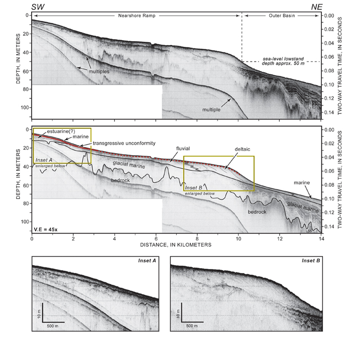
Figure 17. A chirp seismic reflection profile across the inner shelf from near the southern end of Plum Island, Massachusetts, to approximately 70 meters (m) water depth (see fig. 12 for profile location). The top panel is the uninterpreted profile, and the middle panel is interpreted to show geologic units. Fluvial and deltaic deposits overlie glacial-marine sediments, which overlie bedrock. The Holocene sand sheet is separated from fluvial sediments by a transgressive unconformity (red line, where the solid line is interpreted and dashed red is inferred). SW, southwest; NE, northeast; V.E., vertical exaggeration. Figure from Barnhardt and others (2009).