U.S. Geological Survey Open-File Report 2015-1153
![]() / Title Page / List of Figures / Conversion Factors / Abbreviations / Abstract / Introduction / Methods / Results / Discussion / Summary / Acknowledgments / References Cited / Appendix — Geospatial Data / Citation Page /
/ Title Page / List of Figures / Conversion Factors / Abbreviations / Abstract / Introduction / Methods / Results / Discussion / Summary / Acknowledgments / References Cited / Appendix — Geospatial Data / Citation Page /
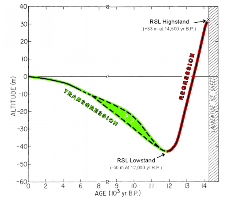
Figure 2. Sea-level curve for the southern Merrimack Embayment from Barnhardt and others (2009), modified after Oldale and others (1993). Following deglaciation, relative sea-level (RSL) fell in northeast Massachusetts in response to ice removal. Near the end of the Pleistocene, about 12,000 years before present (yr B.P.), sea level reached a lowstand of about -50 meters (m) before it began to rise again. Note the age scale changes at 8,000 yr B.P.

![]() U.S. Department of the Interior |
U.S. Geological Survey
U.S. Department of the Interior |
U.S. Geological Survey
URL: http://pubsdata.usgs.gov/pubs/of/2015/1153/figurepages/ofr20151153_fig2.html
Page Contact Information: GS Pubs Web Contact
Page Last Modified: Wednesday, 07-Dec-2016 21:45:11 EST
