U.S. Geological Survey Open-File Report 2015-1153
![]() / Title Page / List of Figures / Conversion Factors / Abbreviations / Abstract / Introduction / Methods / Results / Discussion / Summary / Acknowledgments / References Cited / Appendix — Geospatial Data / Citation Page /
/ Title Page / List of Figures / Conversion Factors / Abbreviations / Abstract / Introduction / Methods / Results / Discussion / Summary / Acknowledgments / References Cited / Appendix — Geospatial Data / Citation Page /
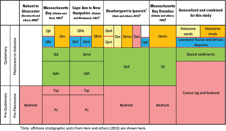
Figure 6.Seismic stratigraphic units interpreted by Oldale and Bick (1987), Oldale and Wommack (1987), and Hein and others (2013). Barnhardt and others (2006) published a depth to sediment thickness map, which was used to identify areas of outcropping bedrock on the inner continental shelf between Nahant and Gloucester, Massachusetts. Transgressive (thick red line) and regressive unconformities (dashed red line) were also identified in several of these studies. The stratigraphic unit names and resolution of these studies differed, but the origin and texture of the deposits can be readily combined into a generalized geologic map (fig. 5) to correlate with sediment textures and physiographic zones presented in this study. QbB and QhbC, Holocene beach and bar deposits; QssD, late Pleistocene to Holocene transgressive sand sheet deposits; QsrtD, late Pleistocene to Holocene regressive-transgressive shoreline deposits; QedD, Holocene ebb tidal delta deposits, QocD, late Pleistocene to Holocene offshore coarse deposits; QmB, QhmC, QmmE, and QmscD, late Pleistocene to Holocene offshore marine deposits; QfeB and QhfC, Holocene fluvial and estuarine deposits; QhdC, Holocene deltaic deposits; QdlD, late Pleistocene lowstand delta deposits; QdB and QmdC, Pleistocene glacial-marine deposits; QdoB and QdtC, Pleistocene coarse drift deposits; QtdD and QtE, Pleistocene drumlin till deposits; TcpB,C, Tertiary and late Cretaceous coastal plain deposits; Pz B,C, Triassic and older bedrock.

![]() U.S. Department of the Interior |
U.S. Geological Survey
U.S. Department of the Interior |
U.S. Geological Survey
URL: http://pubsdata.usgs.gov/pubs/of/2015/1153/figurepages/ofr20151153_fig6.html
Page Contact Information: GS Pubs Web Contact
Page Last Modified: Wednesday, 07-Dec-2016 21:45:14 EST
