Open-File Report 2000-0124
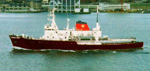
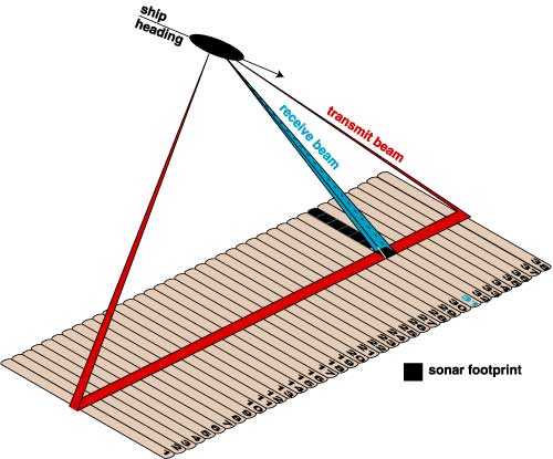
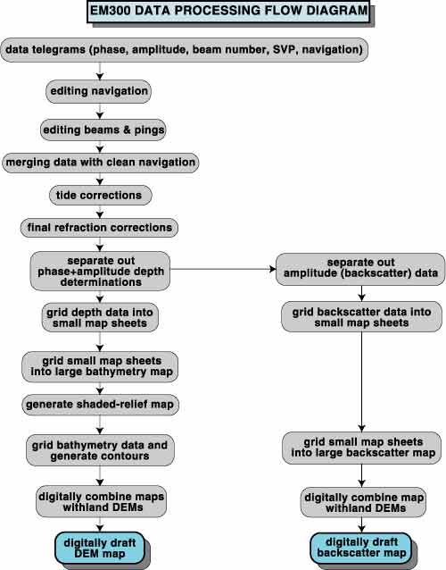
Appendix 1The Kongsberg-Simrad EM300 High-Resolution Multibeam Mapping System The cruise employed the Kongsberg Simrad EM300 high-resolution multibeam mapping system. Details of multibeam mapping systems and specific details regarding the EM300 employed for this survey can be found in Gardner and Hughes Clarke (1998) and Hughes Clarke et al. (1996 and 1998). The system simultaneously collects georeferenced bathymetry and coregistered backscatter (similar to a sidescan sonar image) with precise spatial referencing. Each depth determination of the Simrad EM300 is calculated from both a phase and amplitude detection. A "best" solution is selected based on a set of statistical, quality-control parameters. The Kongsberg-Simrad EM300 utilizes both amplitude (backscatter) and phase detection (bathymetry) for each determination of the bottom depth for each beam, resulting in a measurement accuracy of <0.2% of water depth (RMS). The EM300 system employed for the survey is owned and operated by C&C Technologies, Lafayette, LA, and is hull mounted on the leased Canadian-flag MV Ocean Alert, a 1750 ton, 71-m, converted Coast Guard ship (Figure 28). The EM300 system is a 30-kHz multibeam sonar system with up to 135 individual 1° (vertical) x 2° (horizontal) electronically formed beams (Figure 29). For details see tables A1 and A2, Gardner and Hughes Clarke (1998), and Hughes Clarke et al. (1996 and 1998). The swath width and number of beams used during a survey are dependent on the water depth and mode of operation (Table A1; Gardner and Hughes Clarke, 1998; Hughes Clarke et al., 1996 and 1998). The system can be operated in either equal-angle or equal-distance mode. The equal-angle mode generates 135 1° x 2° receive beams and is configured so that as the beam number increases from nadir, the size of the area imaged by each beam progressively increases. The equal-distance mode varies the individual beam angles so that each beam images the same size area, regardless of the angle away from nadir the beam is pointing. The Hawaiian surveys were operated in equal-angle mode, because sea trials off Honolulu (Gardner and Hughes Clarke, 1988) showed that this mode produced the best results in the water depths of these surveys. The EM300 incorporates roll, pitch, yaw, and heave compensations utilizing an Applied Analytic POS/MV motion sensor that detects motions to 0.01° (Table A2). Yaw steering electronically separates the receive beam into 3, 5, or 9 segments (a center beam and an equal number of segments on either side) and steers each segment to compensate for ship yaw. This innovation, when merged with the system�s differential global positioning system (DGPS), provides a much more accurate geographic determination of the location of individual depth/backscatter values on the seafloor. Navigation is a critical element of any acoustic marine survey so that the location of specific seafloor features and depth values are accurately georeferenced. The navigation accuracy allows other data sets to be registered to the multibeam maps so that specific sites can be reoccupied for sampling purposes or to locate sample information on base maps generated from multibeam data. The ship's heading was determined with a dual differential Global Positioning System (DGPS) with accuracies <0.1°. Positions and time stamps were provided with a DGPS system that gave reliable 1/s fixes with ± 1-m accuracy. Sound velocity profiles (SVP) were calculated several times each day so that ray-tracing techniques could be used to determine the effect of acoustic refraction in the water primarily caused by variations in water temperature and density. Accurate ray tracing allows the precise location of each beam�s projection on the seafloor. A SeaBird CTD was deployed at least once daily to get a reference SVP, and Sippican T5 expendable bathythermographs (0 to 1830-m water depth) were routinely collected several times a day while underway to determine water structure to augment to SVP measurements. Two additional sound velocity profilers are installed at the EM300 transducer arrays to determine the speed of sound in water directly at the transducer. All the SVP data are fed directly into the EM300 processor for instantaneous ray tracing of the individual beams. During the survey the C & C Technologies staff of surveyors and programmers operated the EM300 system. James V. Gardner (co-author) and several graduate students from the Ocean Mapping Program, University of New Brunswick, processed all data aboard ship. James V. Gardner performed all post-cruise processing. Data processing (Figure 30) is a ten-step routine consisting of: (1) editing the navigation to flag bad fixes; (2) editing each ping of each beam, flagging outliers, and bad data; (3) merging depth and backscatter data with corrected navigation; (4) adjusting all depth values to mean low low water based on predicted tides; (5) performing additional refraction corrections for correct beam ray tracing; (6) separating out the amplitude measurements for conversion to backscatter; (7) gridding the depth and backscatter data at the highest resolution possible given the water depths; (8) regridding individual subareas of bathymetry and backscatter into final map sheets; (9) gridding and contouring the bathymetry, and (10) generation of final maps. The preliminary maps were completed aboard ship whereas final maps were completed at the USGS Pacific Seafloor Mapping Lab in Menlo Park, California. |
|
|
For more information, contact the PCMSC team.
Any use of trade, product, or firm names is for descriptive purposes only and does not imply endorsement by the U.S. Government. Suggested citation: Torresan, Michael E. and Gardner, James V., 2000, Acoustic Mapping of the Regional Seafloor Geology in and Around Hawaiian Ocean Dredged-Material Disposal Sites: U.S. Geological Survey Open-File Report 00-124, https://pubs.usgs.gov/of/2000/0124/. U.S. Department of the Interior U.S. Geological Survey |

![]() U.S. Department of the Interior |
U.S. Geological Survey
U.S. Department of the Interior |
U.S. Geological Survey
URL: http://pubsdata.usgs.gov/pubs/of/2000/0124/appendix1.html
Page Contact Information: GS Pubs Web Contact
Page Last Modified: Wednesday, 07-Dec-2016 18:15:51 EST
