Open-File Report 2000-0124
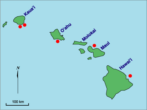
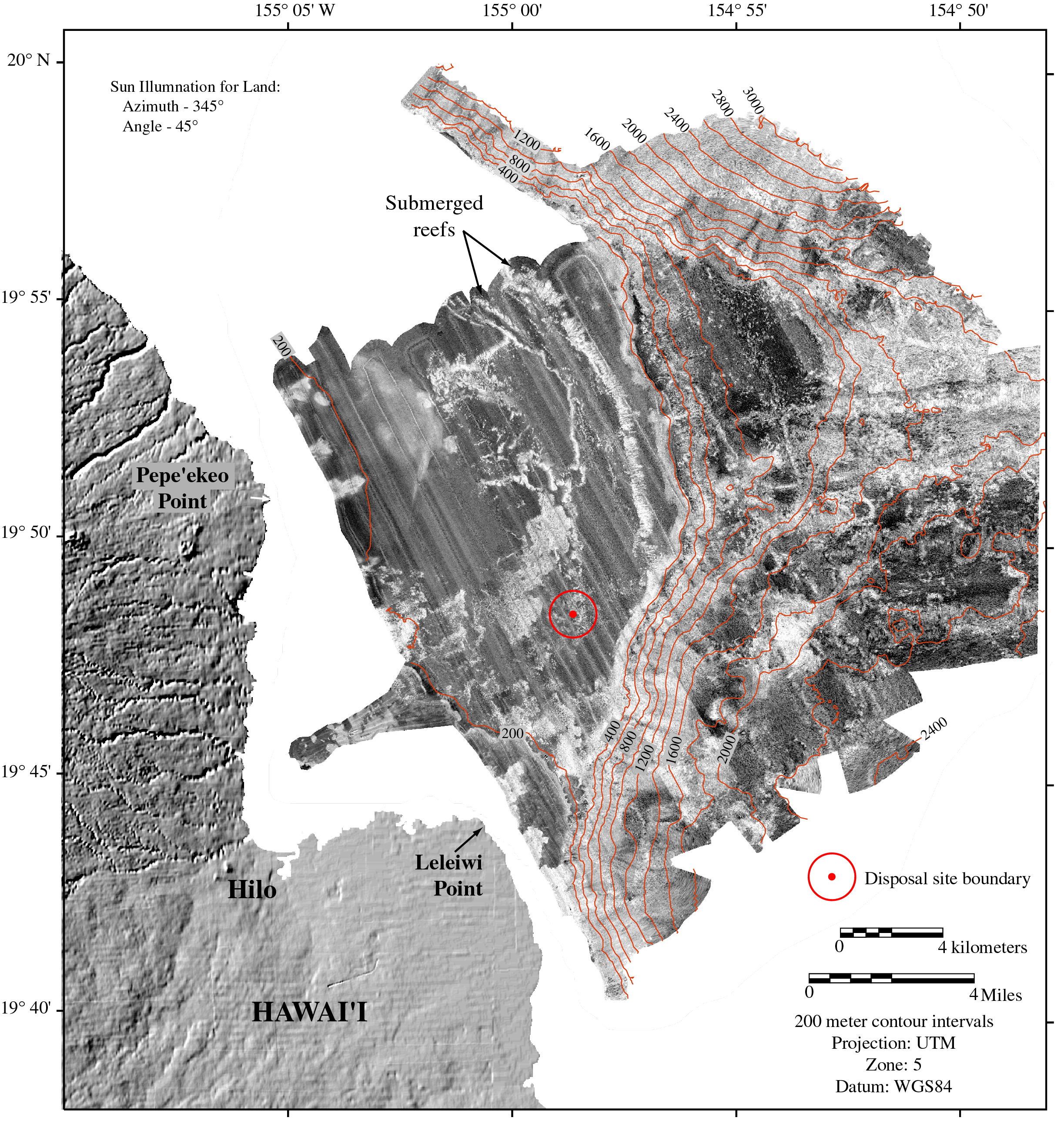
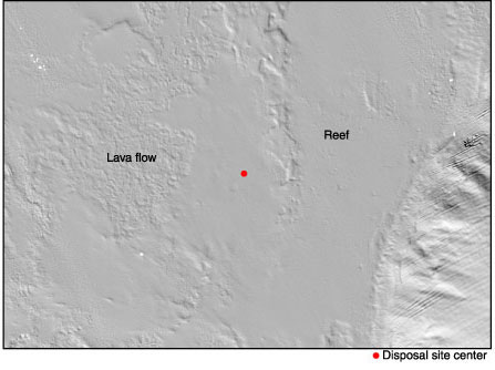
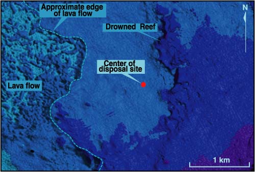
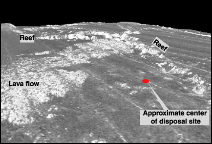
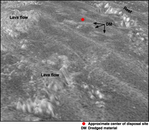
Study Areas, Regional Setting, and Disposal SitesThe five active Hawaiian Island ocean disposal sites shown in Figure 1 service the major harbors for the islands of Oahu, Kauai, Maui, and Hawaii. Each of the disposal sites is located on the submerged flanks of a volcano, and the Hilo disposal site is the only disposal site located near an active volcanic rift zone. The Hilo Marine Disposal Site, HawaiiThe Hilo disposal site (OD0914) is the only site located on the flank of an active volcano. The submarine east flank of Hawaii is dominated by two steep ridges, the Hilo Ridge on the north and the Puna Ridge on the south (Holcomb et al., 1988). The Hilo disposal site is located on the upper reaches of the Hilo Ridge, the submarine extension of the east rift zone of Mauna Kea volcano. The subsidence history of Hilo Ridge suggests it stopped growing 13 ka (Moore and Campbell, 1987). The site is only 29.6 km northwest of the Puna Ridge, the submerged expression of the highly active east rift zone of Kilauea volcano. The imagery shown in Plates 7 and 8 highlights the complex seafloor morphology and backscatter patterns. The morphology of Hilo Ridge visible in the shaded-relief maps (Plate 7; Figure 22) expresses the combined effects of relatively youthful volcanism, island subsidence, and sea-level rise. The ridge morphology is stepped and is formed by a succession of four (or 5) submerged terraces, each of varying size. Each terrace dips gently to the southeast and terminates at a steep change in slope at its outer edge. Terrace 1, the youngest and shallowest terrace, extends from the inner limits of the survey offshore of Leleiwi Point and terminates at about the 200-m contour (Plate 7 and Figure 22). Terrace 2 extends from the base of Terrace 1 at about the 300-m depth out to the 400-m contour, terminating at a 600-m scarp (Figure 22). Terrace 3 extends from the base of the second terrace out to the 1200-m contour. This terrace has an irregular outer margin and diffuse scarp, and a substantial amount of hummocky topography (Plate 7 and Figure 22). Terrace 4 is actually a combination of two terraces that are considered together in this report for simplicity. The distal portion of the fourth and deepest terrace was beyond the limits of the survey area and thus not imaged. What is visible in the shaded-relief map is a complex and irregular seafloor characteristic of rugged volcanic terrain (Plate 7; Figure 22). The Hilo disposal site is located on Terrace 2 about 2 km west of the major 600-m high scarp that marks the southeast border of the terrace (Plate 7; Figures 22, 23, 24, 25 and 26). The site is centered at 19°48.5�N and 154°58.5�W, about 5.25 n mi (8.7 km) northeast of Leleiwi Point on the southern end of Hilo Bay. The Hilo disposal site is defined by a circle with a 3000 ft (914.6 m) radius about its center point and encompasses an area of 2,628,117 m2 (0.8 n mi2) (Plates 7 and 8; Figures 22 and 23). The backscatter map shows the site is bound by a high-backscatter, relatively young lava flow on the west and north, and a high backscatter reef edge on the east (Plate 8; Figures 23, 24, 25, 26, 27). EPA (1980) described the seafloor at the disposal site as smooth silty sand. The dredged material from Hilo harbor is finer grained than the natural seafloor material at the disposal site and is classified as a sandy mud comprising 13% sand, 22% clay and 65% fine sand (EPA, 1980). Note that the dredged material deposits seen on Plate 8 and Figures 23, 25, 26, and 27 appear as rather faint high-backscatter features, especially when compared to the high-backscatter dredged-material deposits observed in Mamala Bay and the Kahului disposal site off of Maui. The typical low-backscatter natural seafloor signature dominates the Hilo disposal site. The faint-nature of the high-backscatter disposal features observed on the Hilo multibeam data reflects the lower volume of dredged material disposed of at the Hilo site (EPA, 1980). A more definitive assessment of the nature, extent, and amount of dredged material cover at the Hilo disposal site requires bottom sampling and photographic surveys. |
|
|
For more information, contact the PCMSC team.
Any use of trade, product, or firm names is for descriptive purposes only and does not imply endorsement by the U.S. Government. Suggested citation: Torresan, Michael E. and Gardner, James V., 2000, Acoustic Mapping of the Regional Seafloor Geology in and Around Hawaiian Ocean Dredged-Material Disposal Sites: U.S. Geological Survey Open-File Report 00-124, https://pubs.usgs.gov/of/2000/0124/. U.S. Department of the Interior U.S. Geological Survey |

![]() U.S. Department of the Interior |
U.S. Geological Survey
U.S. Department of the Interior |
U.S. Geological Survey
URL: http://pubsdata.usgs.gov/pubs/of/2000/0124/hawaii.html
Page Contact Information: GS Pubs Web Contact
Page Last Modified: Wednesday, 07-Dec-2016 18:15:53 EST
