Open-File Report 2000-0124
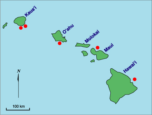
Study Areas, Regional Setting, and Disposal SitesThe five active Hawaiian Island ocean disposal sites shown in Figure 1 service the major harbors for the islands of Oahu, Kauai, Maui, and Hawaii. Each of the disposal sites is located on the submerged flanks of a volcano, and the Hilo disposal site is the only disposal site located near an active volcanic rift zone. The Mamala Bay Marine Disposal Sites, OahuThe South Oahu disposal site (OD0912) is the only active disposal site in Mamala Bay and services Pearl, Honolulu, and Barbers Point harbors. The site is defined by a skewed rectangle having the boundary coordinates 21° 15.97�N and 157° 57.33�W; 21° 15.4�N and 157° 55.97�W; 21°14.97�N and 157° 56.37�W; 21° 14.4�N and 157° 56.37�W. The site�s center coordinates are 21° 15.16�N and 157° 56.83�W, and the site is located about 4.6 n mi (7.8 km) south of the entrance to Pearl Harbor (Plates 3 and 4; Figures 1, 11, 12, 13, 14). Two other disposal sites are located in Mamala Bay, the Old Pearl Harbor and the Old Honolulu Harbor disposal sites (Figure 13). These sites have been inactive since 1980. The Mamala Bay seafloor and the disposal sites are described in detail in Torresan et al. (1995 a, 1995b, 1996, 1998, and 1999), Hampton et al. (1997), and EPA (1980). The bathymetry (shaded relief) and seafloor backscatter are shown in Plates 3 and 4, and Figures 11 and 12. Water depths in the surveyed area vary from about 35 m on the shelf to over 600 m on the southeast corner of the area and exceed 1100 m in the southwest corner of the survey area. The outer part of the Mamala Bay shelf appears along the northern edge ofPlate 3 and Figures 11, 12, 13 and 14. The shelf is less than 50 m deep and extends a minimum distance of 600 m from shore off Diamond Head to a maximum of nearly 5,000 m east of Barber's Point. An extensive prominent step, the Mamala shelf (Ruhe et al., 1965; Stearns, 1974; Gregory and Kroenke, 1982), occurs at the seaward edge of the insular shelf, at water depths to about 100 m. The 3.5-kHz profiles collected in 1993 and 1994 indicate that the step typically is a planar notch cut into the otherwise steeper slope (Hampton et al., 1997). Stearns (1978) observed a drowned reef on the Mamala shelf during submersible dives. Multibeam maps collected in 1998 (Plates 3 and 4; Figures 12, 14, and15) and sidescan-sonar images collected in 1993 (Figures 13 and 16) show that the dredged material is characterized by isolated, circular to subcircular, high-backscatter features. The high-backscatter features are concentrated over the designated sites and are distinctly different in character from the carbonate sand mantling the Mamala Bay seafloor. The aerial extent of dredged material deposits is clearly visible from Plate 4 and Figures 12 and 13. The extent of each dredged material deposit substantially exceeds the area of the three designated disposal sites (Figure 13). Bottom sampling shows that the high-backscatter dredged material is up to 40 cm thick, and comprises a poorly sorted cohesive gray mud mixed with sand-to cobble-size rubble and anthropogenic debris (Torresan et al, 1995a, 1995b, 1996; Hampton et al., 1997). Cores show that the natural, low-backscatter sediment is carbonate sand, composed of carbonate reef and microfauna debris with some volcanic grains (Hampton et al., 1997). Bottom video shows that the seafloor is littered with a variety of anthropogenic debris types including wire rope, 55 gallon drums, military ordnance, refuse, tires, bottles, cans, pottery, concrete blocks and other material. We did not observe significant currents during camera surveys conducted in 1994, but there is abundant evidence of sediment reworking: symmetrical and asymmetrical ripples are present in bottom photographs (Hampton et al., 1997), sand waves are evident on the multibeam maps (Plates 2 and 3; Figures 14 and 15), sidescan images, and 3.5-kHz profiles (Torresan et al., 1995a; Hampton et al., 1997), and moats are present on the down-current sides of the larger exposed reefs in both 3.5-kHz profiles (Hampton et al., 1997) and multibeam images (Plate 3; Figure 14). Winnowed dredged material is visible in the bottom photographs, and box cores show evidence of the post-disposal burial of dredged material by natural sediment (Torresan et al., 1996; Hampton et al., 1997). Most current indicators and large bedforms imply a westerly to northwesterly transport direction, along contours or up-slope, although there are a few areas of easterly indicators (Hampton et al., 1997). The bedforms show that bottom currents can be mechanism for transport of dredged materials and any associated contaminants. The transport mechanism is shown by USGS current-meter data that document episodic, near-bed velocities of 50 cm/sec. |
|
|
For more information, contact the PCMSC team.
Any use of trade, product, or firm names is for descriptive purposes only and does not imply endorsement by the U.S. Government. Suggested citation: Torresan, Michael E. and Gardner, James V., 2000, Acoustic Mapping of the Regional Seafloor Geology in and Around Hawaiian Ocean Dredged-Material Disposal Sites: U.S. Geological Survey Open-File Report 00-124, https://pubs.usgs.gov/of/2000/0124/. U.S. Department of the Interior U.S. Geological Survey |

![]() U.S. Department of the Interior |
U.S. Geological Survey
U.S. Department of the Interior |
U.S. Geological Survey
URL: http://pubsdata.usgs.gov/pubs/of/2000/0124/oahu.html
Page Contact Information: GS Pubs Web Contact
Page Last Modified: Wednesday, 07-Dec-2016 18:15:47 EST
