Open-File Report 2000-0124
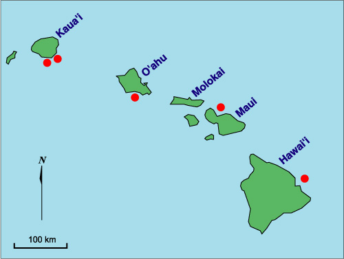
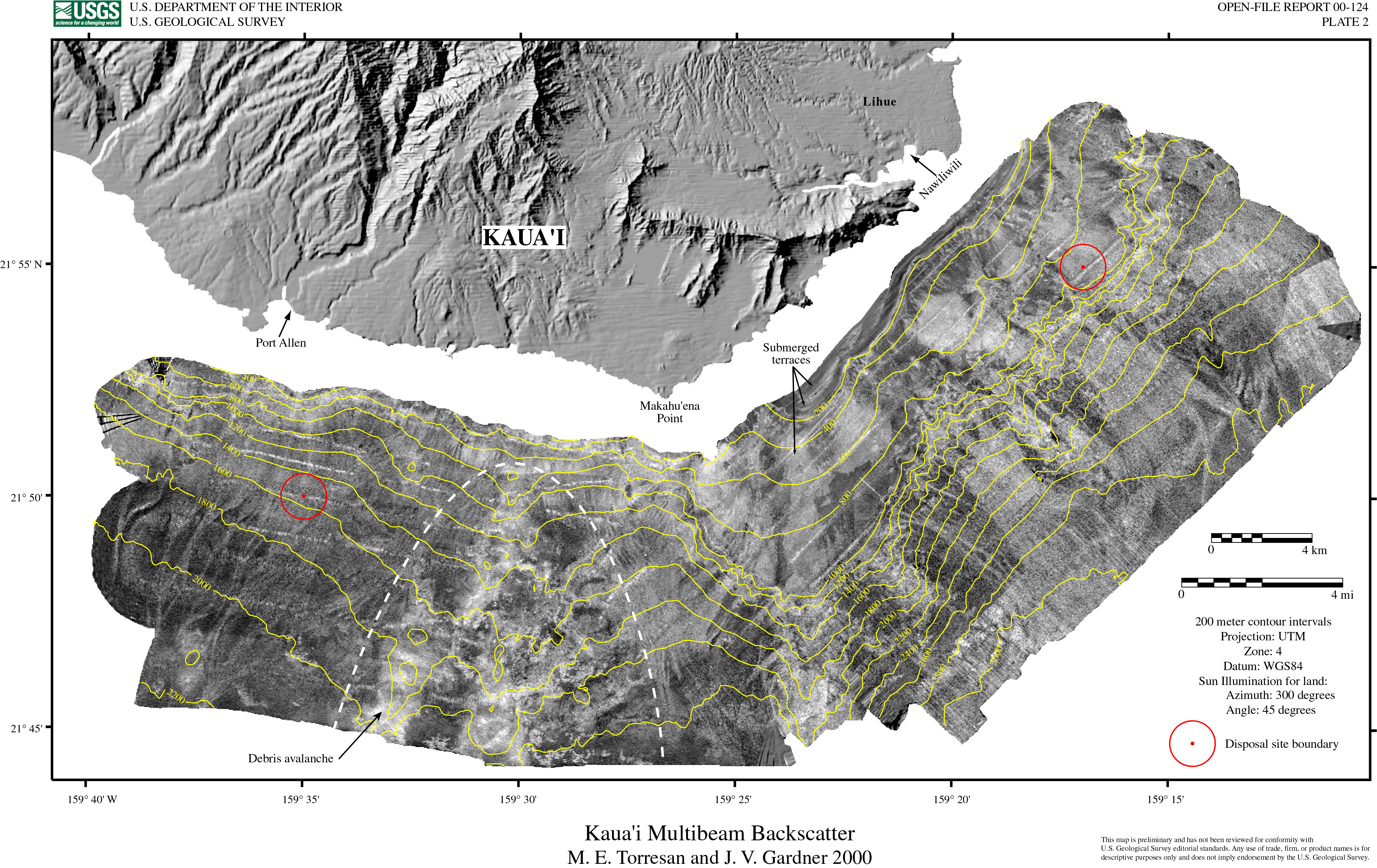
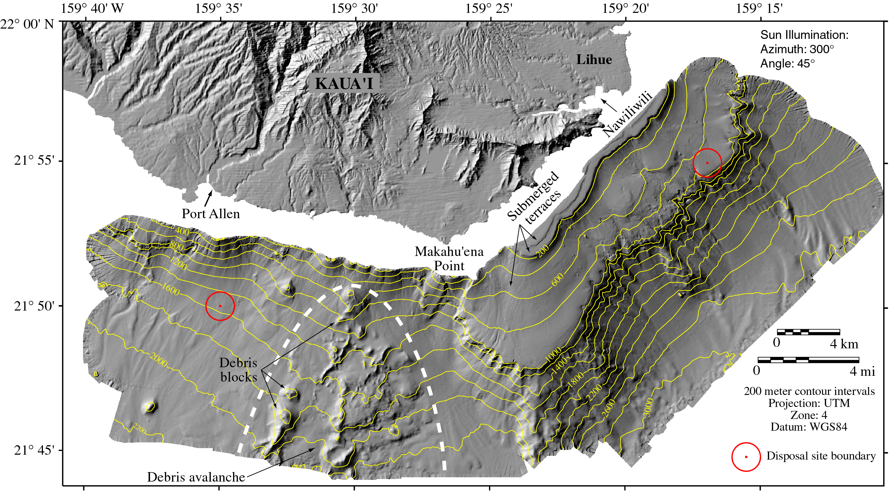
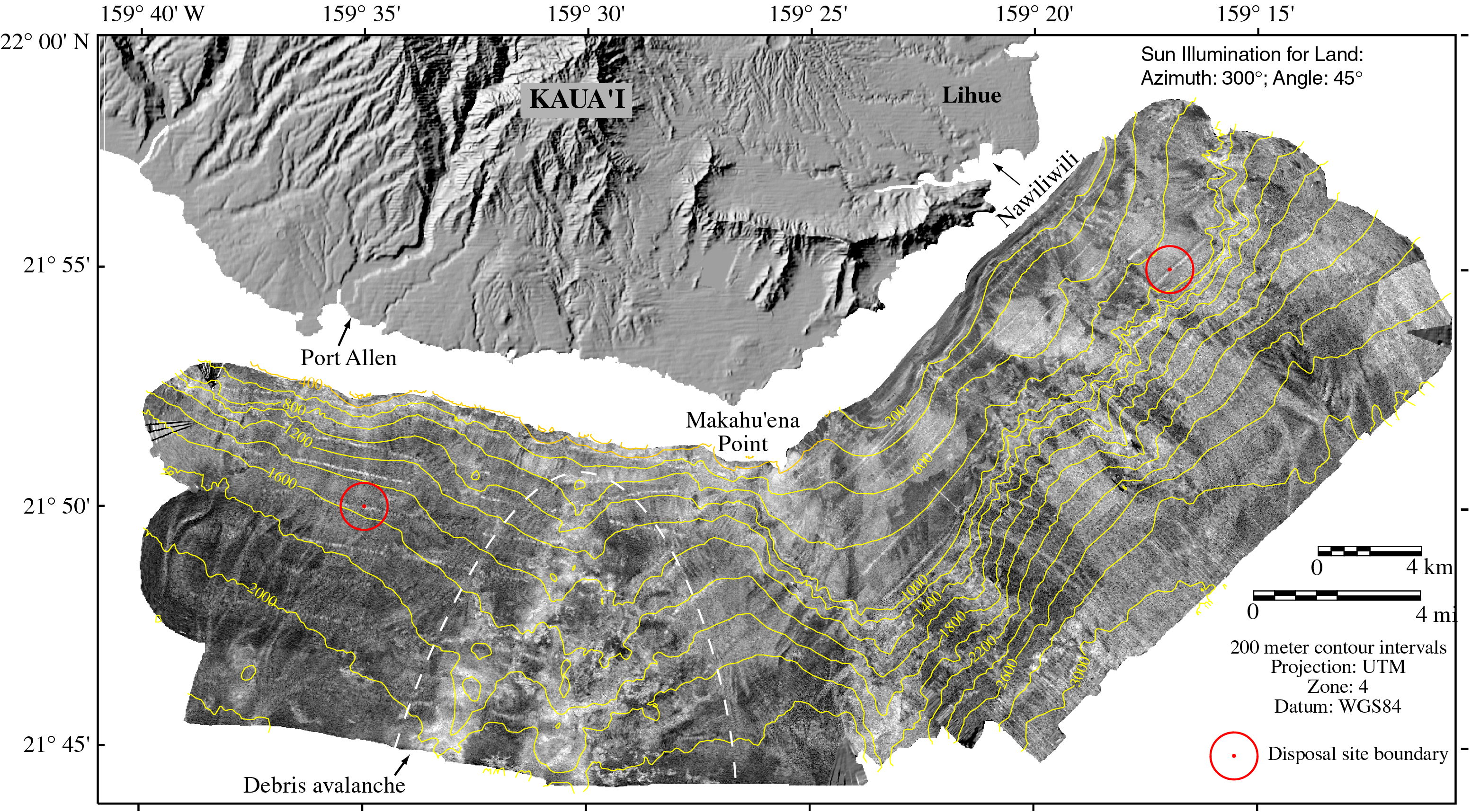
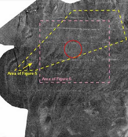
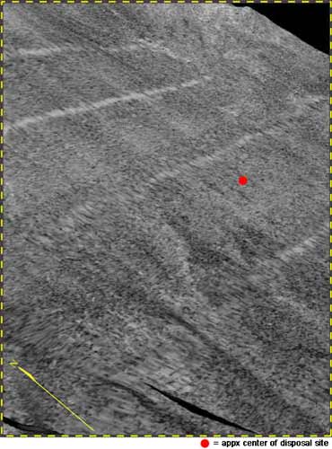
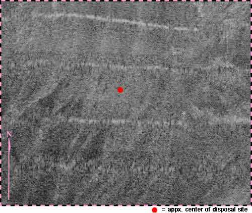
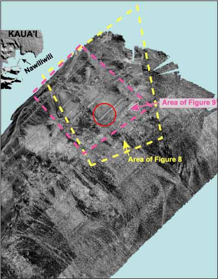
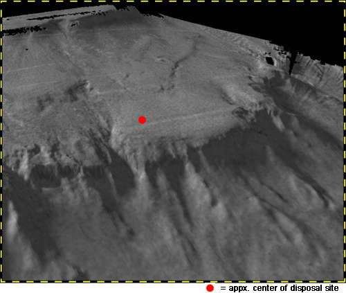
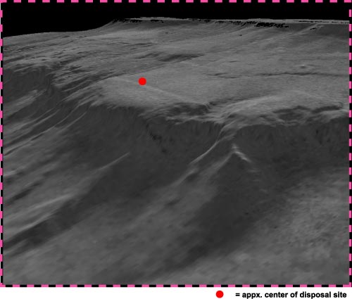
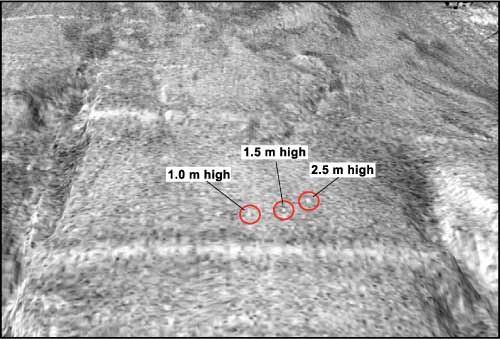
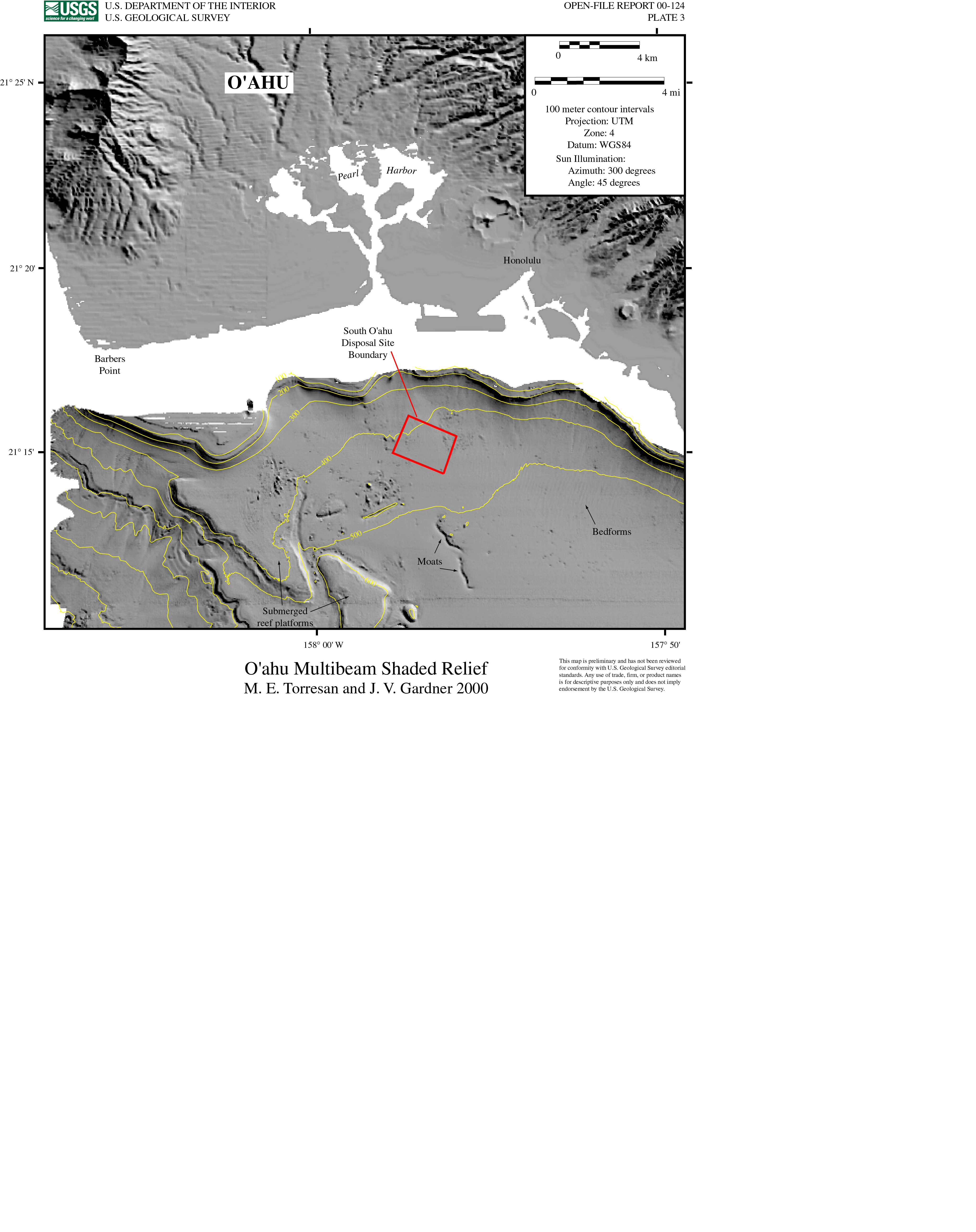
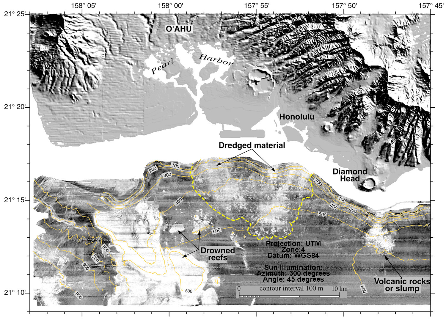
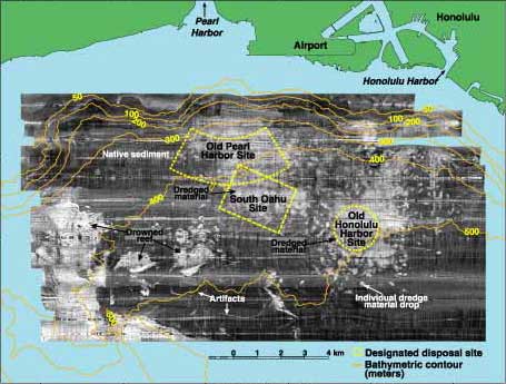
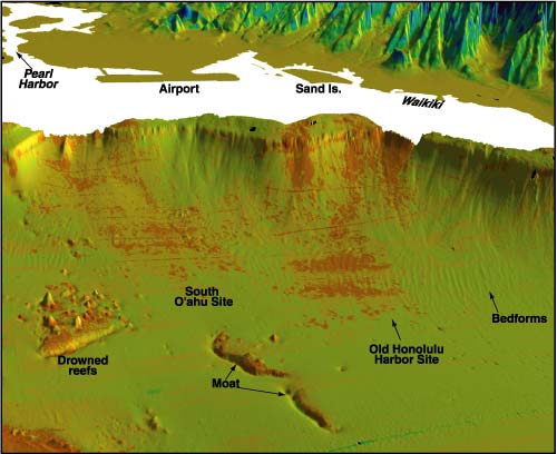
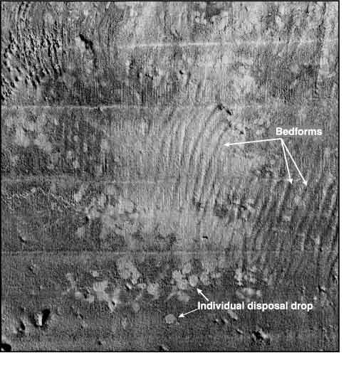
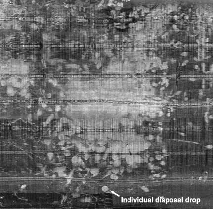
Study Areas, Regional Setting, and Disposal SitesThe five active Hawaiian Island ocean disposal sites shown in Figure 1 service the major harbors for the islands of Oahu, Kauai, Maui, and Hawaii. Each of the disposal sites is located on the submerged flanks of a volcano, and the Hilo disposal site is the only disposal site located near an active volcanic rift zone. The Port Allen and Nawiliwili Marine Disposal Sites, KauaiThe two northern-most disposal sites are located south of Kauai and service both Nawiliwili and Port Allen harbors (Plates 1 and 2; Figures 2 and 3). Both sites are defined as circular areas with a 3000-ft (914.6 m) radius about their center points so that each site encompasses an area of 2,628,117 m2 (0.8 n mi2). The Port Allen disposal site (OD0905) has center coordinates 21° 50.00�N and 159° 35.00�W and is located about 4.8 n mi (8 km) south of Port Allen harbor (Plates 1 and 2; Figures 2 and 3). Water depths range from about 1410 m to 1630 m with the regional slope falling away towards the southwest. The disposal site is located on steep slopes within the headwall region of a gigantic submarine landslide, the South Kauai Debris avalanche, described by Torresan et al. (1989), and Moore et al. (1989). Bottom photographs show that the site consists of a flat, sandy bottom with rocks, boulders, and cobbles (EPA 1980). The Nawiliwili site (OD0904) has center coordinates of 21° 55.00�N and 159° 17.00�W and is located about 4 n mi (7.4 km) southeast of Nawiliwili Harbor (Plates 1 and 2; Figures 2 and 3). The site is situated on the outer edge of a narrow, northeasterly-trending shelf. The narrow shelf slopes towards the southeast and water depths over the site range from 840 to 1120 m. Bottom photographs show a rolling topography strewn with rocks, boulders, and debris (EPA 1980). The entire southeast margin of the island of Kauai, between Nawiliwili on the east and Port Allen on the west, was surveyed with the Kongsberg Simrad EM300 multibeam system in February 1998. Both high-resolution bathymetry and quantitative backscatter were obtained over the entire margin from water depths of 100 to 3500 m (Plates 1 and 2; Figures 2, 3, 4, 5, 6, 7, 8, 9, and 10). The multibeam data reveal that the submarine flanks of the island within the study area are characterized by two distinct morphological styles that reflect processes associated with island construction and evolution. The morphology of the region between Port Allen and Makahu�ena Point on the southwest flank of Kauai reflects the effects of gigantic submarine landslides that have shaped the Hawaiian Islands (Moore et al., 1989). The slope between Port Allen and Makahu�ena Point is the headwall region of a gigantic debris avalanche (Torresan and Shor, 1989; Moore et al., 1989). Much of the original slope material was transported away into deeper water at the time of the failure, leaving behind scars and isolated blocks surrounded by a smooth mantle of sediment (Plates 1 and 2; Figures 2 and 3). The seafloor morphology of the upper southeast margin and flank of Kauai between Makahu�ena Point and Nawiliwili appears much different in character from the southwestern margin (Plates 1 and 2; Figures 2 and 3). The effects of extensive and catastrophic submarine slope failure are not evident along this portion of the study area. The fringing reefs situated off the southeastern corner and along the southeastern side of southern Kauai are intact (Plate1; Figure 2). The major morphologic feature that characterizes the upper-most portion of this submarine flank consists of a relatively broad and gently sloping submerged terrace (Plates 1 and 2; Figures 2 and 3). The terrace dips towards the southeast, trends northeasterly about 45 km in length, and is 10-13 km wide. Backscatter and shaded-relief images show the seaward edge of the terrace slope changes downward into a much steeper regional slope. The major submarine break in slope that occurs at the seaward edge of the submerged platform marks the position of the shoreline when the main period of shield building ceased (Mark and Moore 1987; Moore and Campbell 1987). The shaded-relief map shows that below the terrace the steeper slopes is incised and gullied (Plate1; Figure 2). Multibeam backscatter patterns imply that sediment has migrated downslope via a dendritic pattern of conduits (canyons, gullies and chutes) incised into the slope (Plate 2; Figure 3). Backscatter from the southeast margin of Kauai between Makahu�ena Point and Nawiliwili is as complex as that observed from the southwest margin between Makahu�ena Point and Port Allen. The more elevated and lobate portions of the broad submerged terrace have high backscatter and the steep seaward edge of the submerged terrace is incised with gullies and canyons that lead to smooth, fan-shaped deposits on the lower slope (Figure 2 and Plate 1). The backscatter map in Plate 2 and Figure 3 shows a high-backscatter dendritic network that coalesces down slope into broader areas of high backscatter. The high-backscatter dendritic patterns in Plate 3 and Figure 3 correspond to the terrace-edge chutes and gullies and downslope sediment conduits visible in the shaded-relief maps (Plate 1 and Figure 2). The broad areas of high backscatter on the lower slope (Plate 2; Figure 3) correspond to the broader, smooth, lower-slope sediment mantle visible in the shaded-relief image (Plate 1;Figure 2). The Port Allen disposal site does not show the effects of dredged material disposal in the multibeam backscatter map (Plate 2 and Figure 3). The circular to subcircular high-backscatter features and high-backscatter blanket of dredged material seen at the Mamala Bay disposal sites are not visible at the Port Allen site (Plate 2; Figure 3). Figures 4, 5 and 6 are perspective views of the Port Allen disposal site. Comparing these images to the images in Figures 12, 13, 14, 15, and 16 from Mamala Bay demonstrates the lack of detectable dredged material deposits at the Port Allen disposal site. A close-up multibeam image from the old Honolulu Harbor dredged material disposal site is shown in Figure 15. Note that the dredged material deposits off Honolulu are composed of high-backscatter circular to subcircular overprints that form a nearly continuous high-backscatter blanket over each site. Bottom sampling, photography or higher-resolution multibeam surveys are required to verify the existence of dredged material deposits at the Port Allen site. Figures 7, 8 and 9 are close-up and perspective-views of the Nawiliwili disposal site. These figures do not show conclusive evidence of the high-backscatter features common to disposal sites seen in Mamala Bay and at other sites along the west coast (Gardner and Mayer, 1998). In contrast, Figure 10, a close up backscatter map of the Nawiliwili site shows that isolated 0.5 to 2.0-m high, high-backscatter mounds occur in the vicinity of the disposal site. In fact, the mounds are actually scattered over an area larger than the designated disposal site. These high-backscatter mounds may result from disposal activities, but, similar to the Port Allen site, bottom sampling, photography, or higher-resolution multibeam surveys are required to verify the existence of dredged material deposits at the Nawiliwili disposal site. The lack of evidence for dredged material deposits at the Port Allen disposal site has three possible explanations. The site has received a small volume of material and the site is located in water depths greater than 1000 m. Thus, the Port Allen deposits may be so small and so deep that they are below the resolution of the 30-kHz multibeam mapping system. Second, the dredged material may be so similar to the natural seafloor sediment that they are acoustically identical. Data present in the EPA (1980) report show that the seafloor at the Port Allen disposal site is composed of silty clay. The dredged material from Port Allen and Nawiliwili Harbors is classified as mud (clayey silt/silty clay), thus dredged material contains less sand than natural seafloor sediment. It is hard to imagine that the disposal material is similar enough to the natural sediment to appear no different on the backscatter images. A third explanation for the lack of visible dredged-material deposits at the Kauai sites may be that the dredged materials disperse during settling or after reaching the seafloor, leaving behind no resolvable deposit. |
|
|
For more information, contact the PCMSC team.
Any use of trade, product, or firm names is for descriptive purposes only and does not imply endorsement by the U.S. Government. Suggested citation: Torresan, Michael E. and Gardner, James V., 2000, Acoustic Mapping of the Regional Seafloor Geology in and Around Hawaiian Ocean Dredged-Material Disposal Sites: U.S. Geological Survey Open-File Report 00-124, https://pubs.usgs.gov/of/2000/0124/. U.S. Department of the Interior U.S. Geological Survey |

![]() U.S. Department of the Interior |
U.S. Geological Survey
U.S. Department of the Interior |
U.S. Geological Survey
URL: http://pubsdata.usgs.gov/pubs/of/2000/0124/kauai.html
Page Contact Information: GS Pubs Web Contact
Page Last Modified: Wednesday, 07-Dec-2016 18:15:44 EST
