Open-File Report 2013–1225
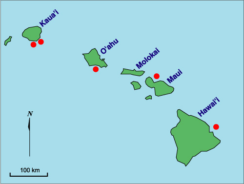
IntroductionContinental shelves adjacent to metropolitan centers are a focus of public concern owing to contamination from runoff, pesticides, wastewater, and other forms of pollution coupled with activities including commercial fishing, transportation, and recreation. Many sites have environmental and management concerns that require geologic information and accurate base maps. A strong focus of the U. S. Geological Survey Coastal and Marine Geology Program (USGS) is the systematic acoustic mapping of the shallow Exclusive Economic Zone (EEZ) seafloor using the latest in acoustic mapping technologies. Data from multibeam sonar, sidescan sonar, subbottom profiling, bottom photography, and bottom sampling provide key information on the seafloor morphology, sedimentary and anthropogenic deposits, and the distribution, transport, and long-term fate of sediment, dredged material, and potential contaminants. Regional mapping assists scientists and users of the marine environment in understanding the geology and how their concerns are influenced by the regional geologic and oceanographic framework. Regional mapping is important for defining areas of critical benthic habitats that may be affected by anthropogenic activities such as ocean disposal. The USGS Pacific Seafloor Mapping Project produces accurately georeferenced base maps and detailed regional syntheses of the seafloor geology that provide the information for a wide range of marine-environmental management decisions. The maps also form a basis for further process-oriented investigations and are prerequisite for long-term monitoring studies, the precise location of sampling sites and critical habitat, and change-detection analyses between temporally separated surveys of the same sites. Since 1993 the USGS, the United States Environmental Protection Agency Region 9 (EPA), and the United States Army Corps of Engineers, Pacific Ocean Division (COE), have conducted cooperative studies aimed at assessing the effects of ocean dumping in the Hawaiian Islands. Through 1997 the studies focussed on Mamala Bay, an embayment adjacent to the city of Honolulu and located on the south shore of Oahu (Figure 1). Mamala Bay is the location of three ocean disposal sites, and has been a repository for dredged materials for over a century. Initially, the purpose of the program was to map and sample the Mamala Bay seafloor, to define the extent of dredged material deposits and to determine the physical and chemical character of the surficial and near?surface materials in and around the disposal sites. The studies include seafloor mapping with sidescan sonar, high-resolution subbottom profiling, bottom photography, seafloor sampling, and sedimentological, chemical, and biological analyses of bottom sediment and dredged material for EPA-defined contaminants of concern. The results are summarized in Torresan et al. (1993, 1995, 1996, 1998) and Hampton et al. (1997). In 1998 the USGS, EPA, and COE expanded the mapping efforts to include all the Hawaiian disposal sites. This report describes the regional setting of the sites, the specific area of each disposal site including the extent of the deposits, and the multibeam mapping system used for the survey. The report also summarizes major results from the mapping and sampling studies conducted in Mamala Bay between 1993 and 1998. |
|
|
For more information, contact the PCMSC team.
Any use of trade, product, or firm names is for descriptive purposes only and does not imply endorsement by the U.S. Government. Suggested citation: Torresan, Michael E. and Gardner, James V., 2000, Acoustic Mapping of the Regional Seafloor Geology in and Around Hawaiian Ocean Dredged-Material Disposal Sites: U.S. Geological Survey Open-File Report 00-124, https://pubs.usgs.gov/of/2000/0124/. U.S. Department of the Interior U.S. Geological Survey |

![]() U.S. Department of the Interior |
U.S. Geological Survey
U.S. Department of the Interior |
U.S. Geological Survey
URL: http://pubsdata.usgs.gov/pubs/of/2000/0124/intro.html
Page Contact Information: GS Pubs Web Contact
Page Last Modified: Wednesday, 07-Dec-2016 18:15:44 EST
