U.S. Geological Survey Open-File Report 2010-1332
|
By Valerie F. Paskevich¹, Florence L. Wong², John J. O'Malley¹,
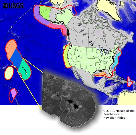
¹U.S. Geological Survey, Coastal and Marine Geology Program, Woods Hole, Massachusetts 02543 U.S. Department of the Interior U.S. Geological Survey U.S. Geological Survey, Reston, Virginia: 2011 Suggested citation: AbstractIn 1983, President Ronald Reagan signed a Proclamation establishing the Exclusive Economic Zone (EEZ) of the United States extending its territory 200 nautical miles from the coasts of the United States, Puerto Rico, the Northern Mariana Islands, and other U.S. territories and possessions. The charter of the U.S. Geological Survey (USGS) places the primary responsibility for mapping the territories of the United States within the USGS. Upon declaration of the EEZ, the territory of the United States was enlarged by more than 13 million square kilometers, all of which are under water. The USGS EEZ-SCAN program to systematically map the EEZ began in 1984 and continued through 1991. This digital publication contains all the GLORIA sidescan imagery of the deep-water (greater than 200 meters) portion of the EEZ mapped during those 8 years of data collection. For each EEZ area, we describe the data collection surveys and provide downloads of the GLORIA data and metadata. DisclaimerThe datasets contained in this report have been approved for release and publication by the USGS. Although these datasets have been subjected to rigorous review and are substantially complete, the USGS reserves the right to revise the data pursuant to further analysis and review. Furthermore, they are released on the condition that neither the USGS, nor the U.S. Government may be held liable for any damages resulting from their authorized or unauthorized use. Any use of trade names is for descriptive purposes only and does not imply endorsement by the U.S. Government.
|

 U.S. Department of the Interior |
U.S. Geological Survey
U.S. Department of the Interior |
U.S. Geological Survey

This report and any updates to it are available at https://pubs.usgs.gov/of/2010/1332/
Page Contact Information: Contact USGS
First posted August 1, 2011