Skip past header information
USGS - science for a changing world

U.S. Geological Survey Open-File Report 2010-1332

GLORIA Sidescan-Sonar Imagery for Parts of the U.S. Exclusive Economic Zone and Adjacent Areas
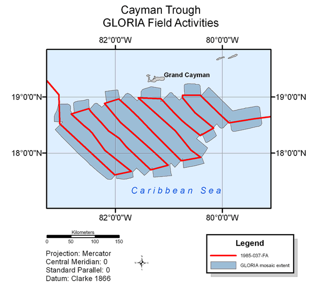

Cayman Trough Field Activities

Skip past contents information
Title Page
Introduction
Methods
Aleutian Arc
Atlantic Coast
Bering Sea
Cayman Trough
  • Field Activities
  • Index Map & Data Links
  • Gulf of Alaska
    Gulf of Mexico
    Hawaii I
    Hawaii II
    Hawaii III
    Johnston Atoll
    Kingman-Palmyra
    Pacific Coast
    Puerto Rico
    Data Catalog
    Acknowledgments
    References
    List of Figures
    Contacts
    The Cayman Trough area GLORIA mosaic.
    Figure 25. The Cayman Trough area GLORIA sidescan-sonar mosaic. Click to enlarge figure.

    Background

    The GLORIA data for the Cayman Trough region were acquired during a single cruise aboard the R/V FARNELLA (1985-037-FA) conducted from October 22 to November 2, 1985. The cruise objective was to insonify the central region of the Cayman Trough. As a result of this survey, two digital mosaics of a 2-degree by 2-degree area were completed (Cruise Report HMS FARNELLA Leg 3B, 1985; EEZ-SCAN 85 Scientific Staff, 1987).

    The GLORIA image of the Cayman Trough area covers approximately 51,508 sq km of seafloor.

    Map showing field activities for GLORIA sidescan-sonar data collection in the Cayman Trough area.
    Figure 26. Map showing field activity for GLORIA sidescan-sonar data collection of the Cayman Trough region. Click to enlarge figure.
    Skip USGS links group

    Accessibility FOIA Privacy Policies and Notices

    Take Pride in America logo USAGov logo U.S. Department of the Interior | U.S. Geological Survey
    End of USGS links group