U.S. Geological Survey Open-File Report 2010-1332
GLORIA Sidescan-Sonar Imagery for Parts of the U.S. Exclusive Economic Zone and Adjacent Areas
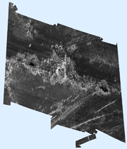
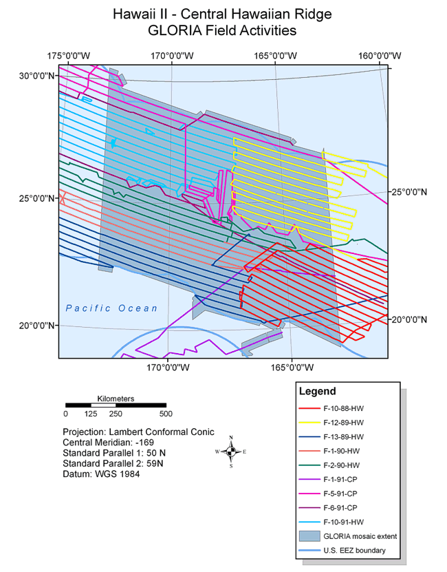
BackgroundData for the U.S. EEZ Hawaii II Central Hawaiian Ridge area GLORIA sidescan-sonar digital mosaic were acquired during nine separate cruises completed from 1998 through 1991. When done a total of 24 digital mosaics at a resolution of 50 m were created of the region. The GLORIA image of the EEZ of the central Hawaiian Ridge covers more than 858,574 sq km of seafloor. The first cruise completed in this area (F-10-88-HW) (McGregor and others, 1991), surveyed on the leeward side of the Hawaiian Ridge south of the island of Kauai, from the Molokai fracture zone on the east to Necker Ridge on the west and was conducted between September 28 and October 22, 1988. This survey spanned both the Southeastern and Central Hawaiian Ridge EEZ areas. The next survey (F-12-89-HW) (Torresan and others, 1991), occurred approximately one year later from November 3 - 26, 1989. The area surveyed was on the north side of the Hawaiian Ridge between Nihoa Island and St. Rogatien Bank. This survey also spanned both the Southeastern and Central Hawaiian Ridge EEZ areas. With the completion of F-12-89-HW the EEZ around the major islands of the State of Hawaii have been imaged. The third survey (F-13-89-HW) (Pickthorn and others, 1991), immediately followed and was conducted from November 28 to December 21, 1989. The area surveyed was the outer part of the remaining territorial EEZ on the south side of the Hawaiian Ridge tying in with the area surveyed by F-10-88-HW on the eastern end at about 167oW and extending to the of the EEZ beyond Kure Island. The following two cruises, F-1-90-HW (Kayen and others, 1990) and F-2-90-HW (Dadisman and others, 1992), were conducted consecutively from January 3 to 28, 1990 and 29 January 29 to February 22, 1990. These cruises were run parallel to one another trending west-northwest and east-southeast south of the Hawaiian Ridge and north of F-13-89-HW to fill gaps left by previous cruises. The remaining four cruises were all done during 1991. The first of these surveys (F-1-91-C) was conducted from January 5 to 28, 1991. Only a couple of transect lines to and from Honolulu were acquired in this area. The majority of this cruise was outside the Central Hawaiian Ridge and focused on the Johnston Island EEZ. The three remaining cruises completed the survey of the northern area of the Hawaiian EEZ. The cruises were conducted from April 24 to May 19, 1991 (F-5-91-CP), and May 21 to June 15, 1991 (F-6-91-CP). The final cruise (F-10-91-HW) was completed from September 27 to October 29, 1991.
|