U.S. Geological Survey Open-File Report 2010-1332
GLORIA Sidescan-Sonar Imagery for Parts of the U.S. Exclusive Economic Zone and Adjacent Areas
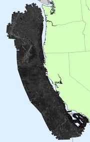
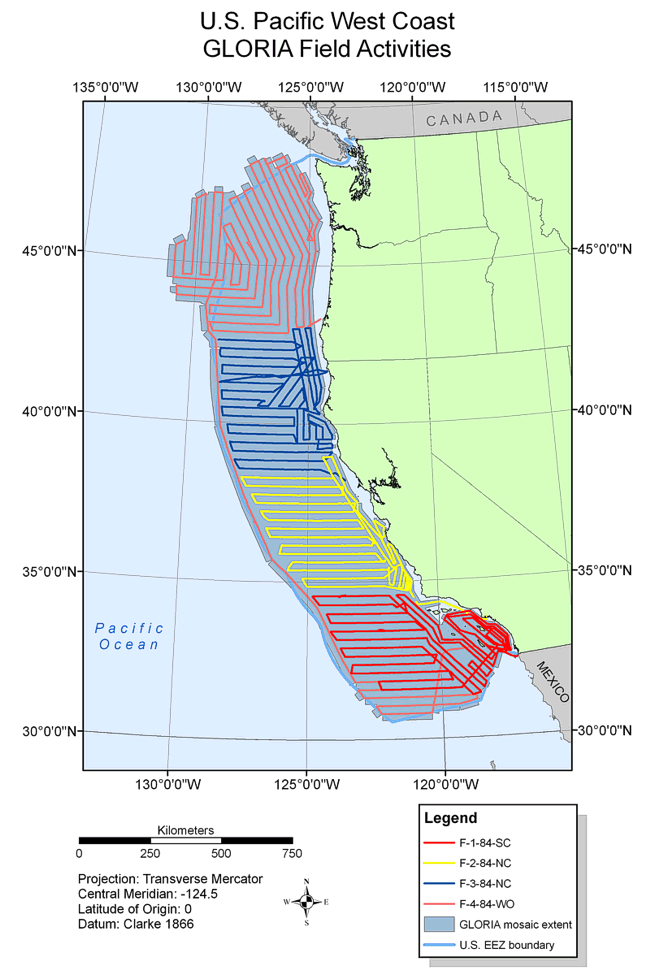
BackgroundThe U.S. Pacific Coast GLORIA survey was a reconnaissance of the entire U.S. EEZ adjacent to the western United States (fig. 49). The GLORIA image of the EEZ off California, Oregon, and Washington (COW) covers about 856,000 sq km of seafloor. The U.S. EEZ Pacific Coast area was the first region to be mapped and launched the GLORIA mapping program. The area covered by the survey extends from the Mexican border to the Canadian border (32o30'N to 48o30'N) and from the continental shelf edge about the 400-m bathymetric contour, to 200 nautical miles from the coast. To insonify this region, four consecutive surveys were completed in the late spring and summer of 1984 (EEZ-SCAN 84 Scientific Staff, 1985). The first survey (F-1-84-SC) departed San Diego, California on April 26, 1984 and arrived at Long Beach, California on May 21, 1984. Obective of this survey was to obtain overlapping sidescan-sonar coverage from the U.S.-Mexican Border (latitude approximately 30o30'N) to Point Conception (latitude approximately 34o30'N) and from the shelf edge seaward to the 200 nautical mile limit. The entire deep-water (below the 300-m isobath) part of the California Continental Borderland, the Patton Escarpment and most of the Baja Seamount Province were insonified during the survey (EEZ-SCAN 84 Scientific Staff, 1985). The second survey (F-2-84-NC) began on May 23, 1984 and completed on June 13, 1984. The objective of this survey was to provide a reconnaissance survey of the entire area from Point Conception to Point Arena central California. This area includes Monterey Fan, as well as the northern portion of Arguelo Fan and the entire Santa Lucia Escarpment (EEZ-SCAN 84 Scientific Staff, 1985). The main object of the third survey (F-3-84-NC) was to obtain GLORIA coverage of the EEZ between Point Arena (39o N) and Coos Bay (43o20' N) off the southern Oregon and northern Californian coast. This area includes much of Delgada Fan, the Mendocino Fracture Zone, Gorda Ridge and the convergent plate boundary off northern California and southern Oregon. The survey departed San Francisco, California on June 15, 1984 and arrived at Coos Bay, Oregon, on July 8, 1984 (EEZ-SCAN 84 Scientific Staff, 1985). The final survey (F-4-84-WO) departed on July 11, 1984 and returned to port in San Diego, California, August 15, 1984. The objection of this survey was to insonify the entire seafloor of the EEZ off Oregon and Washington in water depth greater than 500 m. The survey was extended westward beyond the 200-nm limit of the EEZ where necessary to include Juan de Fuca Ridge. Surveying of the Oregon-Washington EEZ was completed on August 8. In agreement with previous planning, the survey began a southward track toward San Diego to survey a single line along the approximate outer limit of the U.S. EEZ, from Canada to Mexico, as the ship headed to its final destination, the, Port of San Diego, California. The final few days of the cruise were spent filling in some of the area close to the Mexican border and area among the Channel Islands not previously insonified during the first survey (F-1-84-SC) (EEZ-SCAN 84 Scientific Staff, 1985).
|