U.S. Geological Survey Open-File Report 2010-1332
GLORIA Sidescan-Sonar Imagery for Parts of the U.S. Exclusive Economic Zone and Adjacent Areas
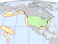
In 1879 Congress established the U.S. Geological Survey (USGS) as a scientific research organization. For more than 130 years, the USGS has examined the geological structure and resources of the nation. The USGS serves the nation by providing reliable scientific information to describe and understand the earth. The information provided by the USGS is helpful in promoting the health and safety of the people, as well as in the management of our natural resources. Scientific advancements that came about as a result of World War II, and the development of sonar technology, significantly improved our knowledge of the ocean basins. By the late 1950s, the scientific community had knowledge of the depths of the world's oceanic trenches and the existence of submarine mountain chains. In 1962, Congress extended the geologic investigations of the USGS into the marine realm. The data collected since then have dramatically altered our perception of the seafloor. On March 10, 1983, President Ronald Reagan signed a proclamation establishing an Exclusive Economic Zone (EEZ) of the United States extending from 3 nautical miles to 200 nautical miles (5.6 km to 370 km) from the coasts of the United States, Puerto Rico, the Northern Mariana Islands, and other U.S. territories and possessions. Upon declaration of the EEZ, the territory of the United States was enlarged by more than 13 million sq km, all of which are under water (Federal Register, 1983). This declaration gave the United States sovereign rights to all natural resources within the EEZ and provided a mandate for reconnaissance exploration. The charter of the In 1984, the USGS began a systematic program to map these areas of the EEZ. To accomplish the mapping of the deepwater (depths greater than 200 m) portion of this area, the USGS selected the long-range sidescan-sonar system GLORIA (Geological LOng-Range Inclined Asdic). At that time the GLORIA system was owned and operated by British colleagues at the United Kingdom's Institute of Oceanographic Sciences (IOS), now the National Oceanography Centre, Southampton (NOCS). The GLORIA system was developed specifically to map the morphology and texture of seafloor features in the deep ocean. From 1984 to 1991, the GLORIA system was used to map approximately seven million sq km of the U.S. EEZ (EEZ-SCAN 84 Scientific Staff, 1986).
|