|
|
|
The U.S. Geological Survey (USGS), the science agency for the Department of the Interior (DOI), has
the critical role of providing scientific information that is utilized to document and understand ecosystem
condition and change in the Chesapeake Bay and its watershed. The findings are used by resource managers
and policy makers to assess the effectiveness of restoration actions and adapt improved strategies for the future.
The Chesapeake Bay, the Nations largest estuary, has been affected by human-population increase resulting in
degraded water quality, loss of habitat, and declines in populations of biological communities. Since the mid-
1980s, the USGS has been a partner of the Chesapeake Bay Program (CBP), a multi-agency partnership working
to restore the Bay ecosystem. The CBP created Chesapeake 2000, an agreement that established over 100 restoration
commitments to be achieved during 200010. The major goals of the agreement are related to: (1) land use,
(2) water quality, (3) vital habitats, (4) living resources, and (5) stewardship.
To support the expanded technical needs of the Chesapeake 2000 agreement,
the USGS summarized its previous research (Phillips, 2002) and interacted
with CBP partners to develop science goals for 200106:
- Improve watershed and land-use data and analysis.
- Enhance the prediction, monitoring, and understanding of nutrient delivery to the Bay.
- Understand the sources and impact of sediment on water clarity and biota.
- Assess the occurrence of toxic constituents and emerging contaminants.
- Assess the factors affecting the health of fish, waterbirds, and their habitats.
- Disseminate information and develop decision-support tools.
The purpose of this report is to present a synthesis of the USGS Chesapeake
Bay science related to the 200106 goals and provide implications for environmental management (fig. 1.1). The report provides USGS
findings that address the science needs of the CBP restoration goals and includes summaries of: (1) land-use
change; (2) water quality in the watershed, including nutrients, sediment, and contaminants; (3) long-term
changes in estuarine water quality; (4) estuary habitats, focusing on submerged aquatic vegetation (SAV) and
tidal wetlands; and (5) factors affecting fish and waterbird populations. A summary of the major CBP restoration
goals and associated USGS scientific findings and their management implications is presented in table 1.
The USGS is also meeting the future needs of the CBP partners. In
2005, which represented the mid-point of the Chesapeake 2000 agreement,
there was growing concern at all levels of government and by the public
that ecological conditions in the Bay and its watershed had not significantly
improved. The slow rate of improvement, coupled with the projected
human-population increase in the Bay watershed, implied that many desired
ecological conditions will not be achieved by 2010. The Government Accountability
Office (2005) recommended that the CBP complete efforts for an integrated
assessment approach of ecosystem conditions and developed a comprehensive,
coordinated implementation strategy. To address these challenges, the
CBP partners are writing a strategic implementation plan (SIP) to more
accurately define the degree to which restoration goals can be achieved
by 2010, and the most effective approach to achieve the goals. The
USGS findings and their implications provide critical information that
will be used by the CBP partners to prepare the SIP and develop improved
management strategies.
Given the evolving needs of the CBP partners, the USGS revised its
Chesapeake Bay Science Plan for 200611 (Phillips, 2005) to provide integrated science for effective ecosystem conservation and restoration,
which are being addressed through four primary themes:
- The causes and consequences of land-use change;
- Factors affecting water quality and quantity;
- Ability of habitat to support fish and bird populations; and
- Synthesis and forecasting to improve ecosystem assessment, conservation,
and restoration.
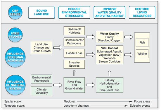
Figure 1.1. U.S. Geological Survey conceptual approach for studies of the Chesapeake Bay and its watershed during 2001-06 and relation to Chesapeake Bay Program issues. |
The USGS has implemented projects to address each science theme through a combination of monitoring,
modeling, research, assessment, and synthesis. The USGS is emphasizing an adaptive management approach for
conducting its projects over the next 5 years so resource managers can use the findings to more effectively implement,
assess, and adapt management actions in different landscape settings (fig. 1.2). The USGS results will:
- Provide an improved understanding of the ecosystem to better target implementation of conservation and
restoration strategies;
- Assess ecosystem change to help evaluate the effectiveness of management activities;
- Forecast the potential impacts of population growth and climate change; and
- Provide implications and decision-support tools to help policy makers and resource managers adopt
improved approaches for ecosystem assessment, conservation, and restoration.
Implementing USGS projects to address the science themes is achieved through collaboration between
multiple USGS National Programs, Science Centers, and partners (Phillips, 2006). Projects are designed by
scientists to meet the objectives of the USGS Chesapeake Bay science themes and missions of the collaborating
USGS National Programs and partners. Appropriate Federal, State, local, and academic CBP partners work with
USGS to jointly conduct monitoring, modeling, research, and assessment activities associated with each science
theme. The USGS interacts with resource managers and policy makers to help them make informed decisions for
conservation and restoration of the Chesapeake Bay and its watershed.
Table 1: Summary
of U.S. Geological Survey (USGS) Chesapeake Bay findings and
management implications.
Findings Related
to the Chesapeake Bay Program (CBP) Chesapeake 2000 Goal for
Sound Land Use |
| CBP Management Goal & Information Need |
USGS Scientific Findings |
Management Implications Application |
Goal: Reduce the rate of harmful sprawl in the watershed.
Need: Develop methods to document and monitor harmful
sprawl. |
The USGS analyzed different indicators
for harmful sprawl, recommended the CBP use impervious surface
as an indicator, and analyzed changes in impervious surface. Analysis
of impervious surface in the watershed showed impervious surface
accounts for 21 percent of all urban lands in the watershed. Impervious
surfaces increased 41 percent during the 1990s compared to an 8-percent
increase in population. (See Chapter
2) |
The rate of increase of impervious
surface implies there will be a more rapid delivery of nutrients
to streams and an increase in sediment erosion. State and local
governments are using the results to conserve habitats to reduce
runoff, increase implementation of stream-restoration actions,
and develop policies to reduce impacts of impervious surfaces. |
Goal: Preserve 20 percent
of land in the watershed.
Need: Identify high value lands to help guide preservation
efforts. |
USGS collaborated with CBP partners
on the Resource Lands Assessment, which identified lands that have
high ecological, water-quality, economic, and cultural value.
The USGS conducted a vulnerability assessment to predict the risk
of conversion of these high-value lands to urban areas by 2010. The
results identified several areas under high development pressure
including the Delmarva Peninsula, southern Pennsylvania, and the
I-95 corridor. (See Chapter 2) |
Land-use change due to population increase
will continue to cause loss of high-value lands. State agencies
and land-preservation organizations have used the methods from
the vulnerability assessment to better target land acquisition
and conservation programs. |
Goal: Assess potential nutrient
and sediment loads in the future due to population increase.
Need: Forecasts of nutrient and sediment loads to the
Bay. |
The USGS began to develop a land-use
change model to predict the impacts of population growth. The model
will be linked with the CBP watershed model to provide scenarios
of nutrient and sediment loading during 2010-30. (See Chapter
2) |
The predictions of nutrient and sediment
loads during 2010-30 will be used to formulate additional strategies
needed to remove the Bay from the impaired waters list. |
Findings Related
to the CBP Chesapeake 2000 Goal for Water Quality—Nutrients.
|
| CBP Management Goal & Information Need |
USGS Scientific Findings |
Management Implications Application |
Goal: Implement the CBP tributary
strategies to reduce nutrients to the Bay and improve water-quality
conditions for living resources.
Need: Better define the spatial distribution of the
sources and transport of nutrients entering the Bay. |
The USGS provided a better understanding
of nutrient sources and their transport to streams and the estuary
using a watershed model application know as SPAtially Referenced Regressions On Watershed
attributes (SPARROW). The SPARROW model results have shown the
spatial distribution of high priority nutrient sources (agriculture,
urban lands, and point sources) and their delivery to the Bay. The
SPARROW model results were also used to improve the spatial resolution
of the CBP Phase V watershed model and to design the CBP nontidal
water-quality network (see Chapter
3) |
Resource managers have identified
several nutrient sources (agriculture, urban lands, and point sources)
as a high priority for nutrient-reduction actions. The SPARROW
model results are being used to identify priority areas
for geographic targeting of management actions. |
Goal: Reduce nutrients to remove
the Bay from the impaired waters list by 2010.
Need: Better define the transport time of nutrients
being delivered to the Bay. |
The USGS determined that on average,
ground water was found to contribute about 50 percent of the water
and nitrogen to the streams and rivers that enter the Bay. The
highest concentration of nitrogen in ground water occurred in areas
overlain by agricultural land. The age of ground water, which affects
the time it takes for nitrogen to travel through shallow aquifers
from the land to a stream, varies from modern to over 50 years
old. About 50 percent of the total water to streams is modern,
with 90 percent moving from its source to a stream in less than
15 years. (See Chapter 4) |
The hydrologic pathways of nutrients
in the watershed (surface water or ground water) will influence
the lag time between implementing management actions and seeing
a water-quality response. Watersheds with a higher percentage of
the nitrogen transported through surface-water runoff will have
more rapid improvements in water quality than those with a higher
portion of nitrogen in ground water. |
Goal: Reduce nutrient delivery
to remove the Bay from the impaired waters list by 2010.
Need: Improve monitoring and better define the factors
affecting the delivery of nutrients entering the Bay. |
The USGS worked with the U.S. Environmental
Protection Agency (USEPA) and the six states in the Bay watershed
to establish the CBP Nontidal Water-Quality Network. Data from
the network are used to document water-quality change that is related
to land-use, implementation of management actions, and climate
variability. The USGS has improved techniques to assess water-quality
change in the Bay watershed and explain the factors affecting the
change. Results from the analysis show streamflow variability has
a large influence on the annual and seasonal loads in the watershed
and their delivery to the Bay. When techniques are used to compensate
for the effect of flow variability, there has been a decrease in
nitrogen and phosphorus concentrations at a majority of the sites
in the watershed. (see Chapter 5) |
The watershed monitoring information
was used to help assess progress in meeting goals to remove the
Bay from the impaired waters list by 2010. Concentrations are not
decreasing at a rate that would reduce nutrient loads sufficiently
to remove the Bay from the impaired waters list by 2010. The USEPA
has recently revised the timeline for delisting the
Bay to be beyond 2010. |
Findings Related
to the CBP Chesapeake 2000 Goal for Water Quality—Sediment
|
| CBP Management Goal & Information Need |
USGS Scientific Findings |
Management Implications Application |
Goal: Reduce
sediment to improve water clarity for submerged aquatic vegetation
(SAV) and remove the Bay from the impaired waters list.
Need: Understand the sources of sediment in the watershed
and their delivery to the Bay. |
USGS analysis of historical sediment
data found the highest yields in the Piedmont, with lowest yields
in the Coastal Plain. Based on results from three research studies,
the portion of sediment from land erosion and stream corridor erosion
varies in individual watersheds and needs to be defined for local
areas. There is a significant amount of sediment and associated
nutrients that are being stored in the forest and wetland assemblages
on the Coastal Plain prior to their delivery to the estuary. Sediment
is also being stored in stream corridors and in reservoirs. (See
Chapter 6) |
Sediment-reduction actions need to
be implemented both in the watershed and in near-shore areas to
improve stream and estuary conditions. In the watershed, practices
should be emphasized in the Piedmont to decrease sediment to tidal-fresh
areas of the estuary. Protecting and restoring forest and wetland
assemblages in Coastal Plain stream corridors can be another effective
approach to minimizing the transport of sediment to the estuary.
Maintaining the sediment storage capacity of reservoirs and dams
will also slow the delivery of sediment from the watershed to the
estuary. |
Goal: Reduce sediment to improve
water clarity for SAV and remove the Bay from the impaired waters
list.
Need: Better document the sediment sources and factors
affecting delivery to the Bay. |
USGS synthesis of sediment information
found that sediment sources to the Bay include watershed inputs,
erosion of shorelines and wetlands, and ocean inputs. The relative
importance of the sources varies in different regions of the Bay.
Watershed sources affect the tidal fresh regions of the estuary.
Below the estuarine turbidity maximum, which is the area of mixing
between freshwater and saline water, erosion from shorelines is
a primary source. The ocean and shoreline erosion are primary sources
of sediment in the southern Bay. Sea-level rise is an important
process affecting sediment erosion from low-lying shoreline areas.
Sediment travel times from the watershed to the estuary may be
decades to centuries. (See Chapter 7) |
In addition to watershed management
actions, practices to improve water clarity in the estuary should
be focused at shoreline sources. Practices to address shoreline
erosion must also consider the sediment erosion due to continued
sea-level rise and climate warming. |
Findings Related
to the CBP Chesapeake 2000 Goal for Water Quality—Contaminants
|
| CBP Management Goal & Information Need |
USGS Scientific Findings |
Management Implications Application |
Goal: Have a “toxics free” Bay
to improve conditions for aquatic- dependent wildlife.
Need: Define the occurrence of contaminants in the Bay
watershed. |
Synthetic organic pesticides, along
with certain degradation products, have been widely detected in
ground water and streams in the Bay watershed. The most commonly
detected pesticides are herbicides used on corn, soybeans, and
small grains. Pesticides were also detected in urban areas, including
insecticides and the herbicide prometon. Pesticides are present
year round but changes in concentrations reflect application rates
and properties affecting their movement. Emerging contaminants
such as pharmaceuticals and hormones are also being detected in
the Bay watershed, with the highest number being detected in municipal
effluent. (see Chapter 8) |
Pesticide occurrence is closely tied
with nutrient land practices on agricultural and urban lands, so
there is potential to better integrate management actions to reduce
both nutrients and contaminants to the Bay. The occurrence
of emerging contaminants and their environmental consequences needs
to be better defined. |
Goal: Have a “toxics free” Bay
to improve conditions for aquatic- dependent wildlife
Need: Document the effect of contaminants on water birds
and wildlife. |
Concentrations of DDT and its breakdown
products and other organochlorine pesticides have declined since
their ban in the 1970s but PCB concentrations remain unchanged. Results
from USGS and U.S. Fish and Wildlife studies indicate that pesticide
concentrations are below thresholds that cause adverse reproductive
effects for some water in the "toxic areas of concern" in
the Bay watershed (Baltimore Harbor, Anacostia River, and Elizabeth
River). (See Chapter 9) |
Management actions in the 1970s and
1980s restricting the use of chlorinated pesticides have had several
results for wildlife. The populations of many fish-eating birds,
such as the bald eagle, have rebounded. However, other contaminants
that are slow to break down remain a threat to wildlife. |
Findings Related
to the CBP Chesapeake 2000 Goal for Vital Habitats—Estuary
Habitats
|
| CBP Management Goal & Information Need |
USGS Scientific Findings |
Management Implications Application |
Goal: Restore water-quality
conditions to support fisheries.
Need: Understand the effect of long-term changes in
climate variability on estuary water quality. |
The USGS found that climate variability
over the past several thousand years has affected the salinity,
temperature, and dissolved oxygen conditions in the Bay. Changes
in these parameters show that the 20th century is characterized
by anomalous climate variability when compared to the last 2,000
years. Water temperatures in the Bay during the late 19th and 20th
centuries exhibited greater extremes than those of the previous
2,000 years. Hypoxia and anoxia were much most extensive and severe
during the past four decades than at any time in the past 2,500
years. (See Chapter 10) |
The results imply that management actions
to address climate variability and associated global warming need
to be incorporated into current strategies to restore the estuary.
Management actions that address delivery of nutrient and sediment
loads under varying river-flow conditions will need to be emphasized
to help address the impacts of climate change and variability. |
Goal: Restore 185,000 acres
of submerged aquatic vegetation (SAV) in the estuary.
Need: Define the factors affecting water clarity and
SAV. |
Investigations showed that the factors
affecting water clarity vary in different areas of the estuary.
Total suspended solids, which include both organic matter and inorganic
solids (clay, silt) are the primary factor affecting water clarity
in the mid-channel sites in the estuary. At shallow water sites,
organic solids were the primary factors affecting clarity during
a low-flow year. Investigations revealed SAV has returned in some
areas of the Potomac, including increased in both native and non-native
species. (See Chapter 11) |
The results imply that managers need
to further define the primary cause of degraded water clarity to
select the types on sediment- and nutrient-reduction strategies
needed in different areas of the estuary. |
Goal: Restore 25,000 acres of
wetlands.
Need: Define the factors affecting wetlands loss and
restoration. |
Sea-level rise, due to climate change, will impact tidal wetlands
during the coming century. USGS forecasts of wetland change in
the Blackwater National Wildlife Refuge reveal that marsh will
convert will continue to convert to open water for the next century. Additional
factors influencing marsh loss include grazing of vegetation by
nutria and waterfowl, altered flooding and salinity patterns, and
annual prescribed burning of vegetation. (See Chapter 12)
|
Coastal wetland loss and landward migration will continue due
to sea-level rise. Managers need to consider land-use policies
that allow for landward migration of wetlands to help preserve
and restore tidal wetlands.
|
Goal: Restore 25,000 acres of
wetlands.
Need: Science to support restoration and conservation. |
The presence of an existing seed bank is important
for wetland restoration. Tidal wetland creation from dredged sediments
is an effective method for restoring wetland habitats when the proper
intertidal soil elevations are established and maintained. Controlling
competition and predation from non-desired species affects the
function and structure of restored wetlands. (See Chapter
12) |
The presence of an existing seed bank, and understanding the
seed dispersal pathways, can increase success and reduce costs
of wetland restoration projects. The success of the restoration
efforts will also depend on controlling competition and predation
from non-desired species, which also attempt to colonize a restored
wetland.
|
Findings Related
to the CBP Chesapeake 2000 Goal for Living Resources
|
| CBP Management Goal & Information Need |
USGS Scientific Findings |
Management Implications Application |
Goal: Restore, enhance and protect
fisheries.
Need: Define the factors affecting lesions on menhaden
and relation to Pfiesteria. |
The USGS and collaborators determined
lesions on menhaden were caused by a fungal pathogen (Aphamonyces
invadans). The same organism was demonstrated in menhaden
from Delaware to South Carolina. It is now recognized that A.
invadans is a serious pathogen of both estuarine and freshwater
fishes worldwide. (See Chapter 13) |
The USGS findings suggest that improving
environmental conditions for menhaden, such as improved dissolved
oxygen and lower contaminant concentrations, will make them less
susceptible to A. invadans infections and other toxic
algae. |
Goal: Restore, enhance and protect
fisheries.
Need: Determine the cause of lesions in striped bass. |
The USGS and collaborators identified
the cause of the skin lesions in striped bass as mycobacteriosis,
which are species of bacteria that can impact both marine and freshwater
fish. The USGS co-hosted a workshop with National Oceanic and Atmospheric
Administration (NOAA) to summarize information about mycobacteriosis.
Bacteria affect relatively high numbers of striped bass, with external
lesions in up to 28 percent of the fish caught and internal lesions
in more than 62 percent. (See Chapter 13) |
The findings imply the resistance of
striped bass populations to disease appears to have been lowered
due to multiple environmental conditions including low dissolved
oxygen, contaminant concentrations, and improper diet. Improving
environmental conditions in the Bay could improve the ability of
striped bass to resist the impact of mycobacteria. |
Goal: Restore, enhance and protect
fisheries.
Need: Develop methods to assess fish health. |
The USGS conducted tributary health
assessments from 1998–2003 to understand fish health in the
Bay and its tributaries. The assessments included developing new
methods to document fish health and use the information to compare
the “health” of various tributaries. Findings from
the assessments showed the suppression of the white perch’s
immune system occurred in several tributaries and changed seasonally.
(See Chapter 13) |
The National Ocean Service of NOAA
is implementing these methods in a program to monitor fish health
in the Chesapeake Bay tributaries. |
Goal: Restore, enhance and protect
fisheries
Need: Assess cause of “intersex” conditions
of fish in the Potomac basin. |
Since 2002, USGS has been involved
with numerous cooperators in examining potential causes for skin
lesions and kills of various fish species in the watershed. During
more comprehensive fish health assessments, the presence of testicular
oocytes, a form of intersex, was noted in the male bass. Reproductive
abnormalities in fish have been strongly linked with a variety
of contaminants that have endocrine-modulating activity. (See Chapter 13) |
Management agencies are awaiting the
results from research to assess causes of intersex and fish kills
in the watershed to begin to formulate actions and policies. |
Department of Interior (DOI) Goal: Manage
populations of waterbirds.
Need: Understand decline in waterfowl populations. |
The USGS has focused on the factors affecting
the declines in seaduck populations, which are a group of ducks
not frequently seen by the public due to the fact that they feed
in deep water in the Bay. USGS findings suggest these declines
could be from changes in diversity and abundance of shellfish and
other benthic foods. (See Chapter 14). |
The findings imply that management
efforts to increase oyster populations could also benefit seaduck
populations. |
DOI Goal: Manage populations
of waterbirds.
Need: Understand impacts of exotic species. |
Food sources and habitats of waterbirds
also are affected by exotic and invasive species. Although data
on the reduction of SAV by nesting mute swans and their offspring
during the spring and summer are limited, studies on their food
habits show that mute swans rely heavily on SAV during these months.
USGS findings revealed a major decline of wild rice in tidal marshes
of the Patuxent River due to consumption by resident Canada geese
(See Chapter 14). |
These findings imply a better understanding
of factors affecting food sources and habitat of waterbirds will
provide managers with more reliable information to manage and regulate
populations. |
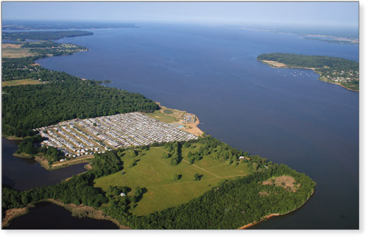
View looking south along the mouth of the Elk River. In the foreground is recent development. Photograph by
Jane Thomas, IAN Image Library (www.ian.umces.edu/imagelibrary/). |
Figure 1.2. Different landscape settings
in the Chesapeake Bay watershed (modified from Phillips, 2005). The
movement of nutrients, sediment, and contaminants in the watershed
and their delivery to the estuary are influenced by the different landscape
settings, which have unique combinations of physical and biological
characteristics. The USGS is providing a better understanding of the
influence of landscape settings on water quality, habitat, and fish and
bird populations to improve implementation and assessment of conservation
and restoration activities. The USGS will conduct the majority of its
activities in the watershed because (1) human-population growth and
land-use change will continue to be the greatest threats to the ecosystem,
and (2) the majority of conservation and restoration actions will be
implemented on land. The USGS will work with partners to relate the
changes in the watershed to the changes in the Bay and its tidal estuaries.
|
References
Bachman, L.J., Lindsey, B.D., Brakebill, J.W., and Powars, D.S., 1998, Ground-water discharge and base-flow
nitrate loads of nontidal streams, and their relation to a hydrogeomorphic classification of the Chesapeake Bay
watershed: U.S. Geological Survey Water-Resources Investigations Report 984059, 71 p.
Government Accountability Office, 2005, Chesapeake Bay Program: Improved strategies are needed to better
assess, report, and manage restoration progress: Washington, D.C., Government Accountability Office Report 0696, 88 p.
Phillips, S.W., ed., 2002, The U.S. Geological Survey and the Chesapeake BayThe role of science in environmental
restoration: U.S. Geological Survey Circular 1220, 32 p.
Phillips, S.W., 2005, The U.S. Geological Survey Chesapeake Bay science plan, 20062011: U.S. Geological
Survey Open-File Report 20051440, 53 p.
Phillips, S.W., 2006, U.S. Geological Survey Chesapeake Bay Studies: Scientific solutions for a healthy bay and
watershed: U.S. Geological Survey Fact Sheet 20063046, 4 p.
Woods, A.J., Omernik, J.O., and Brown, D.D., 1999, Level III and IV ecoregions of Delaware, Maryland,
Pennsylvania, Virginia, and West Virginia: U.S. Environmental Protection Agency, National Health and
Environmental Effects Laboratory, 24 p.
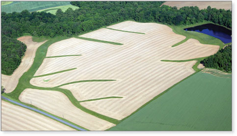
Grassed waterways are an agricultural best management practice that helps
slow down the flow of runoff and absorb nutrients before they reach streams or ground water. Photograph
by Jane Thomas, IAN Image Library (www.ian.umces.edu/imagelibrary/) |
|

