USGS Circular 1316
Synthesis of U.S. Geological Survey Science for the Chesapeake Bay Ecosystem and Implications for Environmental Management | ||||||
Chapter 7: Sediment Sources and Deposition in the Estuary | ||||||
|
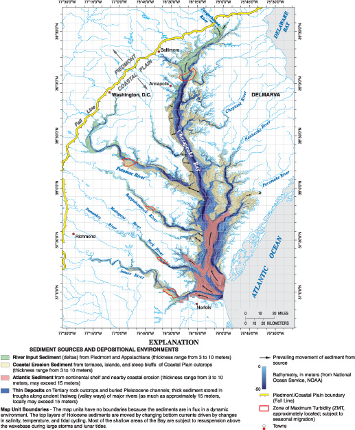
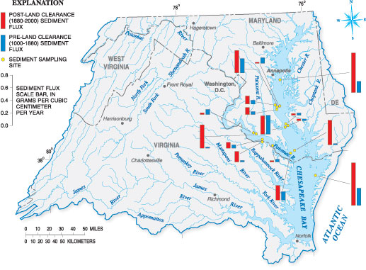
During the past 10 years, integrated studies of sediment in Chesapeake Bay and its tributaries have been carried out by a team of USGS scientists, in collaboration with researchers from several universities, the Maryland Geological Survey, the U.S. Naval Research laboratory, the USEPA, and other institutions. The USGS worked with these investigators to prepare a comprehensive review of sediment processes in the Bay and its watershed (Langland and Cronin, 2003). The current chapter, along with the chapter by Willard on the longterm water-quality changes in the Bay, summarizes the highlights of these studies. Sediment input into the Chesapeake Bay comes from four main sources: riverine input, shoreline erosion, oceanic sediment, and in situ biological (biogenic) sources generated by organisms living in the bay (Langland and Cronin, 2003). The USGS used its understanding of geologic processes controlling sediment to map the probable locations of different sources of sediment entering the estuary (Newell and others, 2004). Although estimates of the relative contributions of different sediment sources vary, the rivers draining the Piedmont and Appalachian Physiographic Provinces are the main sources of sediment to the northern Bay and tidal fresh zones of the major tributaries (fig. 7.1). Shoreline and marsh erosion of Coastal Plain sediments are the primary sources in the central part of the Bay and below the zone of maximum turbidity in major tributaries. Both shoreline erosion and ocean input are major sources of sediment in the southern part of the Bay. Tidal re-suspension of existing sediment on the Bay floor through tides, currents, and waves also produces suspended material, especially in the turbidity maximum zones of the main stem and larger tidal tributaries. Among these sources and processes, sediments from the watershed and shoreline erosion have the greatest potential for reduction by management actions. The USGS examined sediment cores to better understand the amount of sediment delivered from the watershed to the Bay. Analysis indicates a four-to-five fold increase in sediment accumulation in some parts of the Bay since the 1800s, whereas other areas showed no change in sediment rates (fig. 7.2) (Langland and Cronin, 2003). In general, evidence indicates that sediment transport from the watershed to the Bay is not uniform and varies according to local watershed characteristics, storage conditions, and climate variability. As mentioned in the previous chapter, sediment storage greatly influences the transport time in the watershed. Sediment transport from the watershed to the estuary can take decades to centuries (Langland and Cronin, 2003) and contributes to a substantial lag time between watershed erosion (and associated management controls) and improvements in water clarity in the estuary. As a result, the CBP partners are considering emphasizing land-based practices nearer the tidal parts of the Bay to improve water clarity. Sediment erosion from shorelines also varies spatially and temporally because of multiple factors. The amount of sediment erosion from shorelines varies depending on climate conditions (wet or dry years), local geology, shoreline slope and geomorphology, offshore bathymetry, winds, and tides. The Western Shore of the Bay, for example, where headlands and large tidal tributaries draining the uplands are predominant, has different erosion processes than the Eastern Shore, where low-lying tidal marshes are extensive. Since sea level continues to rise in the Bay region at a rate of approximately 1.0 to 1.4 feet per century, and because the rate may be accelerated due to climate warming, shoreline erosion in response to rising sea level is an important process affecting low-lying areas (Langland and Cronin, 2003). The findings imply that, without management of coastal zones, a greater contribution of sediment to the Bay will come from shoreline erosion in the future. The states of Maryland and Virginia are considering sediment management of coastal areas as part of their tributary strategies. Overall, these findings imply that controlling sediment sources in the Piedmont Province of the watershed will be important to improve conditions for the tidal fresh regions of the estuary, and shoreline management actions will be needed to improve water clarity in more saline regions of the estuary.
ReferencesLangland, M.J., and Cronin, T.M., eds., 2003, A summary report of sediment processes in Chesapeake Bay and watershed: U.S. Geological Survey Water-Resources Investigations Report 034123, 109 p. Newell, W.L., Clark, I., and Bricker, O., 2004, Distribution of Holocene sediment in Chesapeake Bay as interpreted from submarine geomorphology of the submerged landforms, selected core holes, bridge borings and seismic profiles: U.S. Geological Survey Open-File Report 20041235, Version 1.0, available online at https://pubs.usgs.gov/of/2004/1235.
| |||||

![]() U.S. Department of the Interior |
U.S. Geological Survey
U.S. Department of the Interior |
U.S. Geological Survey
URL: http://pubsdata.usgs.gov/pubs/circ/circ1316/html/circ1316chap7.html
Page Contact Information: GS Pubs Web Contact
Page Last Modified: Tuesday, 10-Jul-2018 11:04:49 EDT