USGS Circular 1316
Synthesis of U.S. Geological Survey Science for the Chesapeake Bay Ecosystem and Implications for Environmental Management | |||||
Chapter 6: Sources and Transport of Sediment in the Watershed | |||||
|
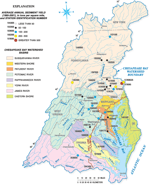
Sediment has an adverse impact on the health of streams in the Bay watershed, SAV, and living resources in the estuary. The CBP partners have commitments to reduce sediment to the estuary to improve waterclarity conditions for SAV and conduct watershed planning to improve the health of streams. The USGS led a synthesis of sediment information by the CBP partners (Langland and Cronin, 2003) and conducted additional studies. This chapter provides a synthesis of USGS findings about sediment sources and transport in the watershed; the following chapter synthesizes sediment sources and deposition in the estuary. The USGS used several methods to assess the sources of sediment in the watershed including (1) analyzing historical data to evaluate areas with the highest sediment loads, yields, and concentrations, (2) assessing the distribution of sediment erosion rates, and (3) using geochemical tracers to determine sediment sources. Gellis, Banks, and others (2004) examined historical annual suspended-sediment loads (tons per year), yields (tons per square mile per year), discharge-weighted concentrations (mg/L), and instantaneous suspended-sediment concentrations (mg/L) for 65 USGS sediment stations operating in the Chesapeake Bay watershed. The highest sediment loads entering the Bay were from the Potomac and Susquehanna River Basins. The sediment loads were highly correlated to drainage area and river discharge, so larger basins usually had larger sediment loads. Sediment yields, which are loads divided by basin area, are used for assessing and comparing sediment generation in different areas of the Bay watershed. The sediment yields ranged from just over 1,000 tons per square mile to under 10 tons per square mile for sediment stations operating from 19852001 (fig. 6.1). Some of the highest yields were in the Conestoga River, a tributary of the Susquehanna River. Agriculture is the predominant land use in the Conestoga watershed and therefore is probably an important contributing factor to the high amount of sediment in this watershed. Sediment yields computed by Gellis, Banks, and others (2004) were further examined to assess the distribution of sediment erosion in the different physiographic regions in the watershed. The sites were classified to fall within six physiographic regions (Coastal Plain, Valley and Ridge, Piedmont, Mesozoic Lowlands, Blue Ridge, and Appalachian Plateau) in the Chesapeake Bay watershed. Watersheds that had a majority of their contributing areas draining the Piedmont had the highest sediment yields, whereas Coastal Plain sites had the lowest sediment yields. The amount of eroded sediment from any one area depends on multiple factors including geology, land use, climate variability, and vegetation. The Piedmont Physiographic Province has a high degree of land disturbance (urban and agricultural land use) and topographic relief that promotes erosion. While the Coastal Plain has similar land disturbance, it has much lower topographic relief (especially on the Eastern Shore) and therefore, less sediment erosion. These findings imply that management actions to reduce sediment to the upper reaches of the estuary would be most effective if they are implemented in the Piedmont Province. These analyses of historical data are fairly consistent with another study approach that was first developed by Brown and others (1988) using a cosmogenic isotope 10Beryllium (10Be) to assess the relative disturbance and acceleration of erosion from upland soils. This technique was used to estimate erosion from 48 basins in the eastern United States, including 10 basins that drain to the Chesapeake Bay. The highest rates of erosion were observed in the Piedmont streams, and the lowest rates were observed in Coastal Plain streams. More recently, the USGS applied this technique to produce erosion indices based on 10Be for selected watersheds in the Susquehanna River Basin (Gellis, Pavich, and others, 2004; Reuter and others, 2005). Many of the higher values indicating significant erosion are clustered in the lower Susquehanna Basin, including the Conestoga watershed. The Conestoga also had some of the higher sediment yields (fig. 6.1), indicating that the 10Be approach is useful in assessing erosion rates in the Bay watershed. The relative contribution of the erosion of sediment from the land surface rather than from stream corridors is not well understood in the Chesapeake Bay basin. The USGS conducted research in three watersheds using a sediment fingerprinting approach to identify the sources of fluvial sediment. Sediment fingerprinting approaches were developed by Walling (2005), and the USGS developed a new algorithm and made use of several geochemical tracers, namely the relative composition of total carbon, nitrogen, and phosphorous in a sample, the stable isotopes carbon 13, nitrogen 15, and two radionuclides (cesium 137, and lead 210) to better identify sources of sediment. Preliminary results show that samples from the Pocomoke watershed on the Eastern Shore of Maryland were found to have up to 75 percent of the sediment eroded from within stream corridors (Gellis and Landwehr, 2006). Land erosion appears to be a higher contributor in other watersheds. The implication of these findings is that detailed information will be needed in local watersheds to identify the primary source of erosion (stream corridors or land erosion) to properly plan and implement sediment-reduction actions.
The time required to transport sediment from the watershed to the estuary depends on the amount of storage in different areas of the watershed. Sediment is stored and trapped in stream corridors, behind dams, and in Coastal Plain flood plains and wetlands adjacent to the estuary. The sediment stored in stream corridors includes a large amount of sediment eroded during land clearance in the 1700s and 1800s, known as legacy sediment (Langland and Cronin, 2003). Merritts and others (2004) proposed that impoundment of sediment behind tens of thousands of mill dams in the Mid-Atlantic Region was the dominant cause of sediment accumulation in streamchannel corridors. As these mill dams were breached or removed, sediment stored behind the dams was eroded and transported. Previous studies by the USGS revealed that dams on large rivers also store large amounts of sediment. Reservoirs on the lower Susquehanna River, for example, trap 70 percent of sediment being transported in the river (Langland and Hainly, 1997). The investigators also found that two of these dams have reached their sediment storage capacity and the lowermost reservoir (Conowingo) may fill in 20 to 25 years. Coastal Plain flood plains and their bottomland hardwood systems remain a critical landscape element for the maintenance of water quality by trapping and storing large amounts of sediment and associated contaminants (Hupp, 2000). These flood plains are among the last places for sediment storage and natural biogeochemical remediation of nutrients and contaminants before entering critical estuarine nursery areas for fish and wildlife. Preliminary USGS results show large amounts of nitrogen and phosphorus are also trapped in sediment in the Chesapeake Bay Coastal Plain flood plains prior to entering tidal waters because of much lower stream gradients and a large amount of flood-plain area (Noe and Hupp, 2005). Therefore, maintaining the ability of the flood plains to retain sediment and associated nutrients is a critical management action for the CBP partners to consider. ReferencesBrown, L., Pavich, M.J., Hickman, R.E., Klein, J., and Middleton, R., 1988, Erosion of the eastern United States observed with 10Be: Earth Surface Processes and Landforms, v. 13, no. 5, p. 441457. Gellis, A.C., Banks, W.S.L., Langland, M.J., and Martucci, S.K., 2004, Summary of suspended-sediment data for streams draining the Chesapeake Bay watershed, water years 19522002: U.S. Geological Survey Scientific Investigations Report 20045056, 59 p. Gellis, A.C., and Landwehr, J.M., 2006, Identifying sources of fine-grained suspended sediment in the Pocomoke River, an Eastern Shore tributary to the Chesapeake Bay, in Proceedings of the Joint 8th Federal Interagency Sedimentation Conference and 3rd Federal Interagency Hydrologic Modeling Conference, April 26, 2006, Reno, Nevada, Paper 5C-1 in CD-ROM file ISBN 0-9779007-1-1, 9 p. Gellis, A.C., Pavich, M.J., Landwehr, J.M., Banks, W.S.L., Bierman, P.R., and Reuter, J.M., 2004, Identifying watershed sediment sources in the Chesapeake Bay: EOS Transactions, American Geophysical Union, Fall Meeting Supplement, v. 85, Abstract H51C-1159. Hupp, C.R., 2000, Hydrology, geomorphology, and vegetation of coastal plain rivers in the south-eastern USA: Hydrological Processes, v. 14, nos. 1617, p. 2,9913,010. Langland, M.J., and Cronin, T.M., eds., 2003, A summary report of sediment processes in Chesapeake Bay and watershed: U.S. Geological Survey Water-Resources Investigations Report 034123, 109 p. Langland, M.J., and Hainly, R.A., 1997, Changes in bottom-surface elevations in three reservoirs on the Lower Susquehanna River, Pennsylvania and Maryland, following the January 1996 floodImplications for nutrient and sediment loads to Chesapeake Bay: U.S. Geological Survey Water-Resources Investigations Report 974138, 34 p. Merritts, D., Walter, R., Lippincott, C., and Siddiqui, S., 2004, High suspended and sediment yields of the Conestoga River watershed to the Susquehanna River and Chesapeake Bay are the result of ubiquitous post-settlement mill dams: EOS Transactions, American Geophysical Union, v. 85, no. 47, p. 903. Noe, G.B., and Hupp, C.R., 2005, Carbon nitrogen, and phosphorus accumulation in floodplains of Atlantic Coastal Plain Rivers, USA: Ecological Applications, v. 15, no. 4, p. 1,1781,190. Reuter, J.M., Bierman, P.R., and Pavich, M.J., 2005, Using GIS to select drainage basins for sampling: An example from a cosmogenic 10Be study of erosion rates within the Susquehanna River Basin: Geological Society of America Abstracts with Programs, v. 37, no. 1, 32 p. Walling, D.W., 2005, Tracing suspended sediment sources in catchments and river systems: Science of the Total Environment, v. 344, p. 159184.
| ||||

![]() U.S. Department of the Interior |
U.S. Geological Survey
U.S. Department of the Interior |
U.S. Geological Survey
URL: http://pubsdata.usgs.gov/pubs/circ/circ1316/html/circ1316chap6.html
Page Contact Information: GS Pubs Web Contact
Page Last Modified: Tuesday, 10-Jul-2018 11:04:49 EDT