USGS Circular 1316
Synthesis of U.S. Geological Survey Science for the Chesapeake Bay Ecosystem and Implications for Environmental Management | ||||||||
Chapter 4: Transport of Nitrogen in Ground Water | ||||||||
|
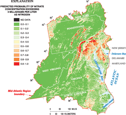
The hydrologic pathways for nutrients have important implications for the lag time between implementing management actions and detecting water-quality changes in surface water. Previous USGS studies documented that on average, just over 50 percent of the total volume of water in streams is from ground water, with a range of 16 to 92 percent for different streams (Bachman and others, 1998). Estimates of the amount of nitrogen delivered to a stream through ground water range from 17 to 80 percent, with an average of 48 percent (Bachman and others, 1998). Additional analysis by Sprague and others (2000) found similar percentages (15 to 65) of total nitrogen in streams from nitrate contributed through ground water. This chapter summarizes USGS findings about the factors affecting the occurrence and residence time of nitrogen in ground water and its discharge to streams. The presence of nitrogen in ground water, which occurs mostly as nitrate, is related primarily to nutrient application in different land-cover settings and natural factors including rock type and denitrification that also influence the amount of nitrate occurring in ground water and its discharge to streams (Lindsey and others, 2003). Previous USGS studies determined that the average concentration of nitrate in ground water under different types of land cover ranged from about 5.0 mg/L (milligrams per liter) in agricultural areas, to 2.0 mg/L in urban areas, and less than 0.1 mg/L in forested areas (Ator and Ferrari, 1997). Results from USGS collaboration with USEPA to assess ground-water vulnerability to nitrogen (Greene and others, 2005) also were used to assess the spatial distribution of nitrate in ground water. The probability of nitrate concentrations exceeding 3 mg/L in the Mid- Atlantic area is shown in figure 4.1. The probability of nitrate exceeding 3 mg/L is greatest in parts of the Coastal Plain, in the northern part of the Piedmont Physiographic Province, and in the carbonate rocks of the Valley and Ridge. This information is useful for resource managers to better understand where ground-water discharge will more likely affect water-quality change in streams in response to management actions. Once nitrate is in ground water, denitrification can be an important process in controlling the amount of nitrogen discharging to streams in some areas of the Bay watershed. In the Coastal Plain, areas with the highest potential denitrification correspond to poorly drained, impermeable soils with abundant organic matter (Ator and others, 2000, 2005). In much of the non-Coastal Plain areas of the watershed, Peper and others (2001) identified near-surface rock formations that contain high amounts of carbon and sulfur that promote denitrification. To better understand the relation between rock type and denitrification, the USGS studied four small watersheds in the major rock types within the Bay basin (Lindsey and others, 2003). Results from this study revealed that denitrification was occurring in the watersheds underlain by unconsolidated rocks (Coastal Plain) and sandstone, shale, and siltstone of the Valley and Ridge, but was not as common in crystalline (Piedmont) or carbonate rocks (Valley and Ridge). Further, the denitrification was significant in ground water with residence times greater than 20 years, but younger, more locally recharged water was not greatly affected by denitrification (Lindsey and others, 2003). Therefore, the influence of denitrification varies greatly throughout the watershed and has implications for management actions. In areas where denitrification is occurring in ground water, resource managers may focus actions to reduce nitrogen in overland runoff from reaching streams. The age of waters being delivered to a stream will be influenced by the relative contribution of surface runoff, soil water, and ground water. Runoff and soil water both have very young ages (hours to months, respectively) and supply, on average, about half of the water to a stream (Phillips and Lindsey, 2003) (fig. 4.2). The remainder of the water supplied to a stream moves through the ground-water system and has a range of modern to over 50 years, with a median age of 10 years. The overall result is that about half of the water entering a typical stream in the Bay watershed can be considered modern, and about 90 percent is less than 15 years old. The relative contribution of surface water, soil water, and ground water will influence the response of the stream to changes in nutrient sources and management actions in a watershed.
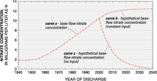
The USGS prepared a ground-water model of the East Mahantango Creek watershed, a predominantly agricultural basin underlain by fractured rock, to predict the change in nitrate concentration in a stream over time (Lindsey and others, 2003). The model used information on the amount of nitrogen applied to the land surface over time in the basin, assumed a ground-water age of about 10 years, and estimated a response of the base-flow (the amount from ground water) nitrate concentrations in a stream (fig. 4.3). The model results indicate that the base-flow nitrate concentration of the stream increased during the last several decades (curve a in fig. 4.3) because of increases in the concentrations discharging from ground water. The increase in nitrogen sources used in the model is typical of many agricultural regions within the Chesapeake Bay watershed. Two future scenarios were examined with the model: (1) continuation of nitrogen applications at current levels, and (2) elimination of all nitrogen applications. The scenario with nitrogen applications at current levels results in a continued increase in concentration of base-flow nitrate in the stream over the next several decades (curve b in fig. 4.3). The scenario with complete elimination of nitrogen applications shows that a 50-percent reduction in nitrate base-flow concentrations could occur in the first 5 years, with a decrease likely to continue until 2040 (curve c in fig. 4.3). Baseflow nitrate concentrations over time in many streams in the Chesapeake Bay watershed likely will be bounded by these two scenarios depending on the amount of nonpoint-source reductions and the relative contribution and age of surface and ground water to a stream. The relative contribution of flows to a stream and their respective ages will influence the lag time between implementation of management actions and improvement in water quality. Streams with a higher portion of surface water and young ground water will have more rapid improvement than streams with higher proportions of ground water of older ages. Knowledge of these differences at local scales can be used to help choose the types of management actions needed and better assess their effectiveness.
ReferencesAtor, S.W., Denver, J.M., and Hancock, T.C., 2000, Relating shallow ground-water quality to surfical hydrogeology in the Mid-Atlantic Coastal Plain, in Proceedings of the National Water-Quality Monitoring Conference, April 2527, 2000, Austin, Texas, p. 409423. Ator, S.W., Denver, J.M., Krantz, D.E., Newell, W.L., and Martucci, S.K., 2005, A surficial hydrogeologic framework for the Mid-Atlantic Coastal Plain: U.S. Geological Survey Professional Paper 1680, 44 p., 4 pls. Ator, S.W., and Ferrari, M.J., 1997, Nitrate and selected pesticides in ground water of the Mid-Atlantic Region: U.S. Geological Survey Water-Resources Investigations Report 974139, 8 p. Bachman, L.J., Lindsey, B.D., Brakebill, J.W., and Powars, D.S., 1998, Ground-water discharge and base-flow nitrate loads of nontidal streams, and their relation to a hydrogeomorphic classification of the Chesapeake Bay watershed: U.S. Geological Survey Water-Resources Investigations Report 984059, 71 p. Greene, E.A., LaMotte, A.E., and Cullinan, K.A., 2005, Ground-water vulnerability to nitrate contamination at multiple thresholds in the Mid-Atlantic Region using spatial probability models: U.S. Geological Survey Scientific Investigations Report 20045118, 24 p. Lindsey, B.D., Phillips, S.W., Donnelly, C.A., Speiran, G.K., Plummer, L.N., Böhlke, J.K., Focazio, M.J., Burton, W.C., and Busenberg, E., 2003, Residence times and nitrate transport in ground water discharging to streams in the Chesapeake Bay watershed: U.S. Geological Survey Water-Resources Investigations Report 034035, 202 p. Peper, J.D., McCartan, L.B., Horton, J.W., Jr., and Reddy, J.E., 2001, Preliminary lithogeochemical map showing near-surface rock types in the Chesapeake Bay watershed, Virginia and Maryland: U.S. Geological Survey Open-File Report 01187, Version 1.0, available online at https://pubs.usgs.gov/of/2001/of01-187/ Phillips, S.W., and Lindsey, B.D., 2003, The influence of ground water on nitrogen delivery to the Chesapeake Bay: U.S. Geological Survey Fact Sheet FS-091-03, 6 p. Sprague, L.A., Langland, M.J., Yochum, S.E., Edwards, R.E., Blomquist, J.D., Phillips, S.W., Shenk, G.W., and Preston, S.D., 2000, Factors affecting nutrient trends in major rivers of the Chesapeake Bay watershed: U.S. Geological Survey Water-Resources Investigations Report 004218, 108 p. | |||||||

![]() U.S. Department of the Interior |
U.S. Geological Survey
U.S. Department of the Interior |
U.S. Geological Survey
URL: http://pubsdata.usgs.gov/pubs/circ/circ1316/html/circ1316chap4.html
Page Contact Information: GS Pubs Web Contact
Page Last Modified: Tuesday, 10-Jul-2018 10:53:40 EDT