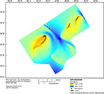
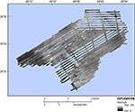
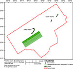
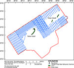
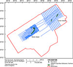
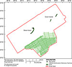
USGS - science for a changing world

Data Series 1005


Archive of Bathymetry and Backscatter Data Collected in 2014 Nearshore Breton and Gosier Islands, Breton National Wildlife Refuge, Louisiana

Skip Links

Citation Page
Abstract
Introduction
Survey Overview and Data Acquisition
Data Processing
Error Analysis
Survey Products
Data Downloads
Logs
Abbreviations
References Cited
 

Data Downloads

The bathymetry DEM is presented in GeoTIFF format and can be opened directly in Esri ArcGIS 10.2 or higher. The map documents and shapefiles provided in this report were created in Esri ArcGIS 10.2.2 and can be found in the GIS Project folder. To open this folder in Esri ArcGIS, right-click and choose “Save As”. The folder contains the .mxd file and all associated vector and raster data. The data layers provided can also be viewed with the free GIS viewer ArcGIS Explorer (http://www.esri.com/software/arcgis/explorer). All data files presented in this report use the projected coordinate system North American Datum of 1983 (NAD83), Universal Transverse Mercator (UTM) Zone 16 North (16N), and all elevations are North American Vertical Datum of 1988 (NAVD88) orthometric heights, derived from the GEOID09 geoid model unless otherwise indicated. Do not use these data for navigational purposes.

Preview File Description File Format Download File Metadata
thumbnail image of data Esri ArcGIS project Esri Files Breton2014-GIS.zip (375 MB)  
Bathymetry DEM
100-m cell size
GeoTIFF 32-bit floating point Breton_2014-DEM.zip (12 MB) Included with download
thumbnail image of data Sidescan Sonar Mosaic 0.50-m resolution GeoTIFF 32-bit floating point 14BIM05_SSS_50cm_WGS84_UTM16N_Tile1.tif.zip (54.5MB)
14BIM05_SSS_50cm_WGS84_UTM16N_Tile2.tif.zip (115 MB)
14BIM05_SSS_50cm_WGS84_UTM16N_Tile3.tif.zip (84.4 MB)
14BIM05_SSS_50cm_WGS84_UTM16N_Tile4.tif.zip (55.9 MB)
Included with download
thumbnail image of data Swath data 5-m BASE resolution – R/V Sallenger ASCII 14BIM01_IFB_xyz.zip (3.8 MB) Included with download
Swath tracklines – R/V Sallenger Esri shapefile 14BIM01_IFB_tracklines.zip (75 KB) Included with download
thumbnail image of data Single-beam soundings – R/V Jabba Jaw ASCII 14BIM02_SBB_xyz.zip (37 MB) Included with download
Single-beam tracklines – R/V Jabba Jaw Esri shapefile 14BIM02_SBB_tracklines.zip (40 MB) Included with download
thumbnail image of data Single-beam soundings – R/V Chum Bucket ASCII 14BIM03_SBB_xyz.zip (29.0 MB) Included with download
Single-beam tracklines – R/V Chum Bucket Esri shapefile 14BIM03_SBB_tracklines.zip (25 MB) Included with download
thumbnail image of data Swath data 5-m BASE resolution – R/V Tommy Munro ASCII 14BIM05_IFB_xyz.zip (7 MB) Included with download
Swath tracklines – R/V Tommy Munro Esri shapefile 14BIM05_IFB_tracklines.zip (22 KB) Included with download

Accessibility FOIA Privacy Policies and Notices

Take Pride in America logo USA.gov logo U.S. Department of the Interior | U.S. Geological Survey
URL: http://pubsdata.usgs.gov/pubs/ds/1005/ds1005-data-downloads.html
Page Contact Information: GS Pubs Web Contact
Page Last Modified: Monday, 28-Nov-2016 20:51:09 EST