|
Sidescan-Sonar Imagery of the Shoreface and Inner Continental Shelf, Wrightsville Beach, North Carolina
|
Results and Interpretations
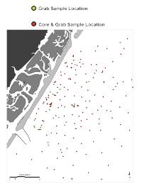
The sidescan-sonar image shown in Figure 1 illustrates the variety of acoustic facies present within the study area. The distinction between similar acoustic facies (e.g., within and between high backscatter areas) is only possible by field groundtruth. Thus, the image interpretation shown in Figure 4 and described here is supplemented by the analysis of surficial sediment and vibracore data collected at the sites shown in Figure 3 (see figure to the right), along with extensive diver observations. The locations of other figures described in the following pages are shown in Figure 5.
Click for the following Results discussion pages:
Rippled Scour Depressions
Submarine Hardbottoms
Inner Shelf Dunes
Exposed Quaternary Channel Fill
Bathymetry
Based on E. Robert Thieler, William C. Schwab, Mead A.
Allison, Jane F. Denny, and William W. Danforth, Sidescan-Sonar Imagery of the
Shoreface and Inner Continental Shelf, Wrightsville Beach, North Carolina: U.S. Geological Survey Open-file Report OF 98-616.
|
Web page: Donna
Newman
[an error occurred while processing this directive]
|
|