|
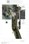
Multibeam Bathymetric and Backscatter Maps of the Upper Hudson Shelf Valley and Adjacent Shelf, Offshore of New York
Results: Striping of Data
Click on figures for larger images.
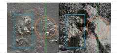
The backscatter data has a weak striping that runs parallel to the ship's track (
Fig. 6 and 7). Some of the striping is the result of poor data return at nadir (directly under the ship) due to rough sea states; this appears as evenly-spaced thin speckled lines. Other parallel striping is the result of differing acoustic responses of the surficial sediments depending on the angle of incidence of the sound front. For example, in the region surrounding 40° 20' N and 73° 47' W the backscatter intensity suddenly increases (lighter shades) about 200 m from nadir. The opposite effect is observed in the region 40° 21.5' N and 70° 46.0' W where the backscatter intensity around nadir is high, then changes to weaker backscatter away from nadir. Further work is needed to understand the acoustic response of the sea floor as a function of incidence angle and sediment characteristics (Clarke and others, 1997). In particular, the striping may be the effect of volume scattering in the region inside the critical angle in areas where a thin veneer of one sediment type over another.
 |
Based on Butman, B., Danforth, W.W., Schwab, W.C., and Buchholtz ten Brink, M.B., 1998, Multibeam Bathymetric and Backscatter Maps of the Upper Hudson Shelf Valley and Adjacent Shelf, Offshore of New York: U.S. Geological Survey Open-File Report 98-616. |
Web page by: Donna Newman
[an error occurred while processing this directive]
|
|