|
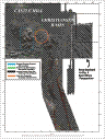
Multibeam Bathymetric and Backscatter Maps of the Upper Hudson Shelf Valley and Adjacent Shelf, Offshore of New York
Results: Outcropping Beds of Coastal Plain Strata
Click on figures for larger images.
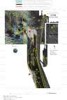
Outcropping beds of coastal plain strata (Schwab and others, 1997), probably of
Cretaceous age, centered at 40° 22.5 N and 73° 48.5 W, dip to the southeast (Fig. 5 and 7). At least 3 scarps formed by these beds, each about 2 m high, face toward the northwest. Individual mounds, hypothesized to be disposed material, sit on this hard substrate, which lies within the old Cellar Dirt Dump Site. The surface sediment (sample station 39, Table 1a) obtained in this region is gravel and sand. To the east of the outcropping strata, there is a local depression where the water is in excess of 38 m deep. This depression is at the southern end of the Christiansen Basin and is separated from the eastern side of the Hudson Shelf Valley by a shallow sill less than 2 m high (Fig. 5 and 6). The continuity of the high backscatter intensity material with the older outcropping strata to the west suggests that the sill may be part of this underlying
formation. To the west of the outcropping strata is a shallow channel, 2-4 m deep,
and about 400 m wide that is floored by fine-grained sediments. The channel is cut into Cretaceous strata and is Pleistocene or early Holocene in age. The channel is oriented northwest-southeast and may be a pathway for movement of sediments from the Dredged Material Disposal Site to the western side of the Hudson Shelf Valley. The presence of numerous small targets, interpreted as individual dumps of material, implies either recent disposal, active scouring around these features, or non-burial as a result of relatively slow accumulation.
 |
Based on Butman, B., Danforth, W.W., Schwab, W.C., and Buchholtz ten Brink, M.B., 1998, Multibeam Bathymetric and Backscatter Maps of the Upper Hudson Shelf Valley and Adjacent Shelf, Offshore of New York: U.S. Geological Survey Open-File Report 98-616. |
Web page by: Donna Newman
[an error occurred while processing this directive]
|
|