|
Multibeam Bathymetric and Backscatter Maps of the Upper Hudson Shelf Valley and Adjacent Shelf, Offshore of New York
Results: Sand Waves
Click on figures for larger images.
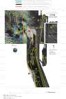
Asymmetric sand waves with low-amplitude crests (less than 1 m high) occur between 73° 43' W and 73° 45' W (see Fig. 5, 6, and 8 above ). The northeastward facing scarps are typically high backscatter. It is hypothesized that these coarse faces have been formed during downwelling storms (winds from the northeast, creating offshore southernly flow near the bottom) that winnow the fine sediments leaving a coarse lag, and that the bed forms suggest transport of material southwestward toward the head of the Hudson Shelf Valley. The sand waves do not exist where water depths are greater than about 26 m. The sand-wave dominated sediments grade into sediments of moderate backscatter around 73° 46' W, then to low backscatter sediment in the axis of the Hudson Shelf Valley around 73° 48' W. The surface sediment samples (Table 1a: stations 3 and 41, and stations 4, 51, 50 and 98) contain increasing amounts of finer sand to the west.
 |
Based on Butman, B., Danforth, W.W., Schwab, W.C., and Buchholtz ten Brink, M.B., 1998, Multibeam Bathymetric and Backscatter Maps of the Upper Hudson Shelf Valley and Adjacent Shelf, Offshore of New York: U.S. Geological Survey Open-File Report 98-616. |
Web page by: Donna Newman
[an error occurred while processing this directive]
|
|