|
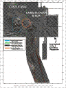
Multibeam Bathymetric and Backscatter Maps of the Upper Hudson Shelf Valley and Adjacent Shelf, Offshore of New York
Results: Evidence for Dumping
Click on figures for larger images.
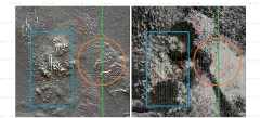
Throughout the survey area, individual features ranging from a few meters (the resolution of the system) to about 50 m in diameter are apparent in the shaded-relief bathymetry and backscatter intensity (see Fig. 5, 6, 7, and 10 above). Some of the targets are topographic highs, but most are depressions, some with a small high in the center. These features are hypothesized to result from individual dumps of material. The features are principally characterized by high backscatter, and are primarily located in the Christiansen Basin region between 73° 46' W and 73° 50' W. Many of the features occur in linear groupings of 5 or more and are often aligned in a northwest-southeast direction. This pattern is consistent with dumping from ships steaming to or from New York harbor. The high-backscatter features stand out especially clearly in the low backscatter region centered at about 40° 24' N and 73° 48' W (fig. 5 and 6). The substrate in this region is fine sand and mud and the depressions are typically 0.5 to 1 m deep and some have a central mound 0.25 to 0.5 m high. The depressions may have formed during disposal as the material impacted the sea floor, or may be a result of scour by currents and/or animals around the dumped material. In contrast, the targets in the area centered at 40° 22.5' N and 70° 48.5' W and to the northwest, where the substrate is interpreted to be hard (see below), the targets occur as topographic highs (fig. 5 and 7). Some of the features may be"derrick stones", which are large rocks that required a derrick to unload from barges (Williams, 1979). Since the early 1900's, the disposal region for derrick stones was 4 to 6.25 miles southeast of Scotland Light, about the location of the present Dredged Material Disposal Site. Although most of the individual targets now visible are to the east of this location, disposal was probably not confined to the designated sites. The linear pattern of the features suggests an anthropogenic origin, and the distribution suggest that large areas of the sea floor outside of the designated disposal sites have been used for ocean disposal.Visual observations are needed to confirm the interpretation of these ubiquitous individual targets.
 |
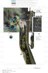
Based on Butman, B., Danforth, W.W., Schwab, W.C., and Buchholtz ten Brink, M.B., 1998, Multibeam Bathymetric and Backscatter Maps of the Upper Hudson Shelf Valley and Adjacent Shelf, Offshore of New York: U.S. Geological Survey Open-File Report 98-616. |
Web page by: Donna Newman
[an error occurred while processing this directive]
|
|