|
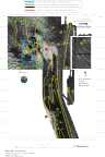
Multibeam Bathymetric and Backscatter Maps of the Upper Hudson Shelf Valley and Adjacent Shelf, Offshore of New York
Results: Present Dredged Material Disposal Site
Click on figures for larger images.
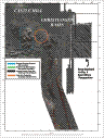
The present Dredged Material Dump Site (DMDS) (see Fig. 5,6 and 7) is marked by several mounds of material that
extend to within 16 m of the surface; the shallowest mound (at 40° 22.7' N and 73°
51' W) is about 12 m from the sea surface. Elongate paired features, on the order of
50 to 75 m long and 40 m wide, are scattered throughout the site (see Fig.7).
Their relief typically is about 1 m and some of the features are separated by depressions
about 1 m deep. It is hypothesized that these are signatures of individual dumps of
material from barges. Linear features on the order of
100 m long and aligned northwest-southeast, are observed on the saddle (40° 23.25' N and
73° 51.4' W) between the southern disposal mound and the present disposal site at water
depths between 16 and 18 m. These linear features have about 0.5 m of relief. A few features with similar characteristics are observed to the north of the southern
disposal mound (see Fig. 5).
The origin of these features is unknown.
An area of uniformly smooth topography and low backscatter extends to
the northeast, east, and southeast of the DMDS for about 1-2 km (see region between 40°
23' and 40° 24' N and 70° 50' W (Fig. 5, 6, and 7). The absence of the backscatter and
bathymetric signatures of individual dumps in this area which are ubiquitous throughout
much of the adjacent area, suggests that this area may be composed of fine material
winnowed from the disposed dredged material and transported eastward and downslope toward
the head of the Hudson Shelf Valley. The composition of the two surface
sediment samples (stations 38 and 48, Table 1) obtained in
this region, which are both clayey silt, support, but does not prove this
hypothesis. Another region of relatively smooth topography and low backscatter
(between 40° 22'N and 45° 23' N and centered at 73° 52' W) is found to the
west of the DMDS. A circular region south of the DMDS (centered at 40° 22' N and 73°
51' W) is approximately 1 km in diameter and is characterized by relatively low
backscatter intensity. Within the circular region, there are at least 10 individual
mounds less than 2 m in height. This feature represents the site where
sediments contaminated with dioxin were disposed and capped with sand in the late 1980's.
Based on Butman, B., Danforth, W.W., Schwab, W.C., and Buchholtz ten Brink, M.B., 1998, Multibeam Bathymetric and Backscatter Maps of the Upper Hudson Shelf Valley and Adjacent Shelf, Offshore of New York: U.S. Geological Survey Open-File Report 98-616. |
Web page by: Donna Newman
[an error occurred while processing this directive]
|
|