|
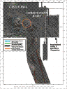
Multibeam Bathymetric and Backscatter Maps of the Upper Hudson Shelf Valley and Adjacent Shelf, Offshore of New York
Results: Hudson Shelf Valley
Click on figures for larger images.
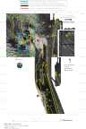
The axis of the Hudson Shelf Valley is floored with low-backscatter intensity
sediment. The amount of mud (silt plus clay) is higher here than on the adjacent
shelf, and ranges from 31 to 95 percent in the valley (see stations 96, 8, 9, 156, 11, 12, 157, and 13; Table 1a). Some of the samples have a significant amount of sand, but most is very fine sand (4 phi) that can be transported as suspended load (i.e., the stress required to keep this material in suspension is less that the stress required for initiation of movement (Butman, 1987). The increased amount of finer-sized material in this region supports geochemical and seismic observations which show that sediments are accumulating in the upper part of the valley. The axis of the Hudson Shelf Valley forks at about 40° 17.5' N (Fig. 5); the shallower western fork extends to about 40° 23' N, just east of the Dredged Material Disposal Site. The main channel on the eastern side continues northward to about 40° 22' N where it meets the shallow sill at the southern end of the Christiansen Basin. The ridge between the two axes is 2-4 m shallower than the western fork, and the material is characterized by coarser (higher backscatter intensity) material than to the east or west.
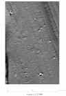
The upper region of the Hudson Shelf Valley 22 km south of Ambrose Light (at about 40° 16' N) is a site for disposal of unsalvageable hulks (Williams, 1979). The multibeam surveys show targets in this region that are characterized by high backscatter and positive relief (Fig. 5, 6 and 9). Several targets are identified as wrecks.
Based on Butman, B., Danforth, W.W., Schwab, W.C., and Buchholtz ten Brink, M.B., 1998, Multibeam Bathymetric and Backscatter Maps of the Upper Hudson Shelf Valley and Adjacent Shelf, Offshore of New York: U.S. Geological Survey Open-File Report 98-616. |
Web page by: Donna Newman
[an error occurred while processing this directive]
|
|