|
Multibeam Bathymetric and Backscatter Maps of the Upper Hudson Shelf Valley and Adjacent Shelf, Offshore of New York
Results: Historic Disposal Sites
Click on figures for larger images.
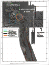
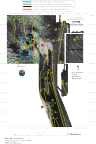
There are two topographic highs in the northwest corner of the survey region, each approximately 2 km in diameter (see Fig. 5). The two highs are composed of material dumped in the late 1800's and 1900's (Williams, 1979). The northern high (shallowest point at 40° 25.5' N and 73° 51.6' W), referred to as Castle Hill, is material dumped prior to the 1930's. The southern high (shallowest point at 40° 24' N and 73° 51.75' W) is composed of material dumped between 1930 and 1975. The crests of these highs are about 16 m below the sea surface, approximately 8 m shallower than the adjacent sea floor to the west. The material on the crest of the northern high is shaped into a series of sand waves with crests running approximately northwest-southeast. The amplitude of these sand waves is less that 2 m. Patches of strong backscatter are superimposed on a background of weak backscatter (Fig. 6). The strong backscatter covers a larger percentage of the surface area along the eastern side of the disposal mounds than along the western side. Additional sampling and photographic observations are needed to determine the causes of differing backscatter. Along the crests of the mounds the background backscatter intensity is weak (dark); it grades to a stronger return (lighter) on the flanks at a water depth of about 20 m. This transition is clearest on the western side.
 |
Based on Butman, B., Danforth, W.W., Schwab, W.C., and Buchholtz ten Brink, M.B., 1998, Multibeam Bathymetric and Backscatter Maps of the Upper Hudson Shelf Valley and Adjacent Shelf, Offshore of New York: U.S. Geological Survey Open-File Report 98-616. |
Web page by: Donna Newman
[an error occurred while processing this directive]
|
|