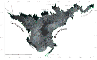
Surficial Geology and Distribution of Post-Impoundment Sediment of the Western Part of Lake Mead Based on a Sidescan Sonar and High-Resolution Seismic-Reflection Survey
Results
Post-Impoundment Sediment
Click on each figure for larger image with caption.
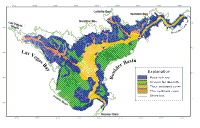
The sediment that has accumulated in the lake since impoundment has a uniform low-backscatter signature associated with its surface (Fig. 4). This sediment fill has been divided into two provinces based on the seismic-reflection data; namely thin and thick sediment cover (Fig. 5). Sediment thickness will be discussed more in the description of the seismic data. Because of the continuous coverage of the lake floor provided by the sidescan mosaic,
the outline of the post-impoundment deposits can be mapped in more detail than can be derived from the seismic profiles that are spaced several hundred meters apart. The thick sediment fills the former Colorado River channel and laps up against the older rock and alluvial units that are exposed along the flanks of the lake (Fig. 9, Fig. 11). Because of the dramatic contrast in acoustic signatures, the edge of the thick sediment unit is easy to identify.
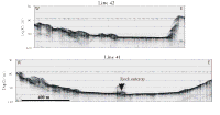
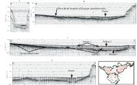
This deposit has an irregular edge with embayments and promontories coinciding with tributary valleys and spurs that were formed prior to the lake being formed (Fig. 5). Along the contact with alluvial deposits, the narrow embayments coincide with small valleys in the surface of the alluvial fans that have been partially filled. Within the area of thick sediment cover, the backscatter signature is not uniform. Discontinuous patches of slightly higher backscatter such as the area south of Callville Bay or at the mouth of the channel that originates in Las Vegas Bay may reflect areas where surface sediments are slightly coarser grained (Fig. 4). This inference awaits confirmation by direct sampling. In addition to these broader patches of moderate backscatter, there are also two parallel bands of moderate backscatter that are most clearly expressed in the area of thick sediments immediately south of Swallow Bay Fig. 11. These two moderate backscatter bands occur on the flanks of an extremely subtle channel that is evident in the seismic profiles that cross it Fig. 11. The seismic profiles suggest that the surface expression of this channel is in the same location as the original Colorado River channel, and that the channel on the lake floor only has about 2-m relief.
The thin sediment cover is not as extensive as the thick sediment cover, and is limited to the floors of the tributary valleys in the axes of Las Vegas, Swallow, Callville, and Hamblin Bay (Fig. 5). The seismic profiles show that sediment cover in these valley floors is patchy (especially in Swallow, Callville and Hamblin Bays) and rarely exceeds 2-m in thickness. The uniform nature of the low-backscatter signature from these valley floors suggests that, at most, only a thin veneer of sediment has accumulated in these areas since impoundment Fig. 12. The fact that many of the seismic profiles in these areas show no sediment cover suggests that it is too thin to be resolved by the seismic system Fig. 12. Therefore it is probably less than about 0.5 m thick. High-backscatter targets in places along this channel floor are probably boulders, and their presence further supports thin sediments that have not completely covered the pre-existing geology Fig. 12.
Seismic-reflection profiles were used to map the thickness of sediment that has accumulated on the lake floor (Fig. 6, Fig. 7).
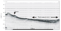
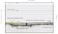
Sediment that is interpreted to have accumulated since formation of the lake shows as an unit with some continuous internal reflectors on these subbottom profiles (Fig. 6, Fig. 8, Fig. 11, Fig. 13).
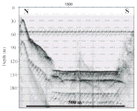
The top of this transparent unit is flat, and it fills the deepest parts of the valleys in the lake floor (Fig. 8, Fig.13A). This transparent unit rests on top of a high-amplitude reflector that merges with the present lake floor where the transparent unit pinches out (Fig. 9, Fig. 11, Fig. 13B).
Where the transparent unit pinches out consistently coincides with the transition from sediment cover to rock or alluvial deposits on the sidescan imagery (Fig. 8, Fig. 9, Fig. 11). Although cores are not yet available to confirm this interpretation, the close correlation of the sediment distribution based on the seismic profiles with that derived from the sidescan imagery further supports the interpretation of this transparent unit being the post-impoundment sedimentary section. The post-impoundment sedimentary unit sometimes has as many as four discontinuous reflectors within it Fig. 6. The origin of these reflectors is unknown, and will require cores for the explanation.
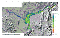
The sediment thickness map shows that post-impoundment sediment is limited to a relatively small part of the lake floor Fig. 7. It is thickest and most continuous in the deep, flat central part of Boulder Basin where water depths exceed 125 m. The sediment in Las Vegas Bay and Callville Bay by contrast is thin and discontinuous. Much of the lake floor has no post-impoundment sediment covering it at all Fig. 7. Sediment in the floor of Boulder Basin locally exceeds 30 m in thickness, but in most of this area it is less than 20 m thick. It is thickest over the channel of the former Colorado River (Fig. 8, Fig. 9, Fig. 11, Fig. 13D). Although rare, there were a few places along the axis of the former Colorado River where the post-impoundment sediments were too thick to be penetrated by the chirp subbottom profiler. In these areas, sediment generally exceeded 35-m in thickness. In the narrow parts of the lake, specifically near Hoover Dam and in Boulder Canyon, the sediment thins abruptly against the steep rock walls that flank these parts of the lake, but is a fairly constant thickness along the axis of the channel. Exceptions to the thick sediment cover do occur locally in Boulder Canyon where it thins to less than 4 m thick Fig. 7. In the central part of Boulder Basin, where the flanks of lake floor have gentler gradients, the extent of post-impoundment sediment is broader, and it thins gradually rather than abruptly at its edges (Fig. 7, Fig. 9, Fig. 11, Fig. 13B). Here, large areas of the deposit are less than 10 m thick.
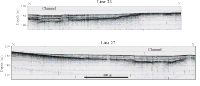
Four reflectors have been identified in this post-impoundment deposit (Fig. 6, Fig. 13C). These reflectors all are flat-lying. The youngest one is 1-2 m below the lake floor and the older ones are 4-5 m, 7-8 m, and 18-19 m below the lake floor respectively (Fig. 13. The oldest reflector, because of the shape of the basin has a more limited extent than the younger ones. The horizontal nature of these reflectors results in the oldest reflector being limited to the central part of the basin while the younger ones have a broader extent (Fig. 13. No places were observed where these older reflectors were exposed on the lake floor. A shallow channel, with less than 2-m relief, is present on the floor of Boulder Basin Fig. 11. This channel can also be seen in each of the reflectors in the subsurface which suggests that this channel has been present throughout the filling of the lake (Fig. 11, Fig. 13).
|