OF 02-152 Home
DVD-ROM
Contents
Geologic
Discussion
GIS Data
Contacts
|
Quaternary Sedimentary Deposit Click on each figure below to view larger image. Click on figure number to go to figure-caption page for links to images in PDF format and for further explanation of the images.
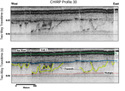
Holocene Sedimentary Deposit Mapping the Holocene ravinement surface
(Fig. 7), and thereby determining the
thickness of Holocene sediment (Fig. 9),
was hampered by resolution limits of the CHIRP data and by the absence
of boomer subbottom data over much of the study area. Thus, the
maps of the Holocene ravinement surface and of the Holocene sediment
thickness are less accurate than maps of older units. The Holocene
sedimentary deposit is, for the most part, an acoustically amorphous,
relatively thin, fine- to medium-grained sand deposit. In some areas
of the inner shelf, generally in water > ~20 m, an
 |
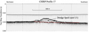
| Figure 17. Seismic-reflection profile showing the Holocene ravinement surface. Also a link to larger image. |
acoustically transparent unit a few milliseconds thick appears on
the sea-floor on CHIRP profiles (Fig. 17).
Informally designated as unit U1 by Lotto (2000), this sandy transparent
unit could not be mapped accurately due to resolution limitations
of the CHIRP subbottom data. We assumed, however, that unit U1, however,
is part of the Holocene sedimentary deposit and mapped it accordingly.
Deposit U1 is more continuous and
thicker (2-3 m thick) in the upper Hudson Shelf Valley. There, U1
was cored by Buchholtz ten Brink and others (1996), and found to
be sandy, organic-rich, black silt. Seismic and geochemical evidence
suggest that approximately 7-10% of the sewage sludge dumped in
the NY Bight is contained in deposit U1 in the Hudson Shelf Valley
(Lanier and others, 1999).
Material being dredged from the New
York - New Jersey harbor area is currently disposed offshore at
the HARS (Figs. 2a and 4).
The sea floor in the Historic Area Remediation Site (HARS) is marked
by several mounds of material, the shallowest of which extends to
within 12 m of the sea surface (Butman and others, 1998). One of
these mounds occupies a site where sediments contaminated with dioxin
were dumped and capped with sand in the late 1980's. Such a deposits
(Fig. 18) are indistinguishable from
unit U1 on our subbottom profiles collected on the inner shelf outside
the
 |
| Figure 18. Seismic-reflection profile showing disposed dredged material in the Mud Dump Site. Also link to larger image. |
dumpsite (Fig. 17) and in the Hudson
Shelf Valley (Fig. 14). Sidescan-sonar
images of the dumpsite exhibit a patchy high- and low-backscatter
pattern with circular impact trails of capping sands, which were dumped
by hopper dredges (Schwab and others, 1997a, 1997b, 2000a; Butman
and others, 1998) (Figs. 2a and 4).
The elevated sea floor around the Mud Dumpsite (Fig.
2a) suggests that this anthropogenic deposit is up to 8 m thick
(Butman and others, 1998).
To view files in PDF format, download free copy of Adobe Acrobat Reader www.adobe.com/products/acrobat/alternate.html. |