OF 02-152 Home
DVD-ROM
Contents
Geologic
Discussion
GIS Data
Contacts
|
Previous Investigations
Click on each figure below to view larger image. Click on figure number to go to figure-caption page for links to images in PDF format and for further explanation of the images.
The first investigations of the subsurface
structure of the continental shelf off the New York - New Jersey
metropolitan area were seismic-refraction studies by Ewing and others
(1950; 1963) and Brown and others (1961). These studies identified
a large sedimentary basin off the coast of New Jersey adjacent to
a shallow buried platform south of Long Island, later named the
Baltimore Canyon Trough and the Long Island Platform, respectively
(Fig. 3). A major fault, the New York
Bight Fault, extends along the western margin of the New York Bight
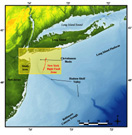 |
| Figure 3. Index map showing major regional geologic features of the study area. Also link to larger image. |
Basin, a Mesozoic rift basin (Hutchinson and Grow, 1984). Early single-channel
seismic-reflection investigations of the sedimentary sequences in
the Long Island Platform and Baltimore Canyon Trough were conducted
by Robertson (1964), Emery and Uchupi (1965), Uchupi and Emery (1967),
and Garrison (1970). Later, Schlee and others (1976) used multi-channel
seismic-reflection profiling to identify acoustic reflectors within
the upper Late Jurassic-Cenozoic strata of the Baltimore Canyon Trough
and Long Island Platform. They allowed for a rudimentary reconstruction
of the effects of post-Triassic rift sea-level oscillations on the
stratigraphic evolution of the shelf and identification of five regional
acoustic horizons within the upper sedimentary units of the Long Island
Platform.
High-resolution seismic-reflection
data were collected in 1968 to help evaluate potential aggregate
resources off the south shore of Long Island (Williams, 1976). Although
these profiles were located approximately 1.5 km apart and are of
relatively poor quality compared to present standards of digitally
acquired data, Williams (1976) was able to create a rudimentary
description of the inner-continental shelf sedimentary sequences.
Williams (1976) indicated that Upper Cretaceous coastal-plain strata
are unconformably overlain by Pleistocene sediments south of Long
Island, with no preservation of Tertiary sedimentary units. This
regional unconformity, first identified by Emery and Uchupi (1965),
is believed to have been created initially during the mid-Oligocene
and is correlative with the Atlantic coastal-plain Reflector of
Poag (1978) and Hutchinson and Grow (1984). The unconformity also
has been identified as a contact between Late Cretaceous to early
Tertiary strata and overlying Pleistocene sediment under the adjacent
subaerial areas of New Jersey and Long Island, New York using well-log
data (Suter and others, 1949; Enright, 1970). In many places within
the study area the Pleistocene sediment cover is thin or missing
and the Late Cretaceous to early Tertiary coastal-plain strata crop
out on the
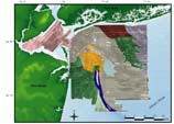 |
| Figure 4. Geologic interpretation of sidescan-sonar image. Also link to larger image. |
sea floor (Williams and Duane, 1974; Williams, 1976; Schwab and
others, 1997a, 1997b, 2000a) (Fig. 4).
The Quaternary stratigraphy of the
New York Bight continental shelf was strongly impacted by Pleistocene
glaciation as the study area was situated in front of the terminus
of the Wisconsinan Laurentide continental ice sheet (Fig.
5). Thus, the study area was affected by glacial isostatic rebound,
forebulge collapse, and re-emergence (Dillon and Oldale, 1978) and
was characterized by glacially induced major sea-level fluctuations
described by Shackleton and others (1988). The repeated emergence
and submergence of the continental shelf led to the dissection of
the Cretaceous to early Tertiary coastal-plain strata and Quaternary
section by subaerial fluvial incision, and
 |
| Figure 5. Map showing southern limit of Wisconsinan glacial advance & positions of proglacial lakes formed in late Pleistocene. Also link to larger image. |
shoreface ravinement during the transgression. This has resulted
in a Wisconsinan glacial outwash-plain and modern barrier-island complexes
resting unconformably over a sequence of pre-Wisconsinan Pleistocene
glaciofluvial and shallow marine units (Suter and others, 1949; Soren,
1978; Oldale and Coleman, 1992). These processes have left a reworked,
lithologically complex Quaternary stratigraphic record composed of
age-mixed deposits resulting from similar physical processes, but
differing widely in the time of genesis. Long Island and New Jersey
well log-data indicate that preservation of Pleistocene and Holocene
strata is quite patchy (Suter and others, 1949; Enright, 1970).
The 170-km-long Hudson Shelf Valley,
the largest physiographic feature on the continental shelf (Figs.
1 and 3), bisects the New York Bight
region. The Hudson Shelf Valley is the submerged seaward extension
of the ancestral Hudson River drainage system that, unlike most
incised valleys on the Atlantic shelf, has not been infilled with
sediment. The valley head is located in a broad shallow basin (Christiansen
Basin) and extends offshore 20-40 m below the shelf surface to a
seaward terminus at a shelf-edge delta (Ewing and others, 1963;
Emery and Uchupi; 1972; Uchupi and others, 2000). Weiss (1974) hypothesized
that the ancestral Hudson River began to develop in the Late Cretaceous
when post-Atlantic rifting caused continued uplift and tilting of
the margin, resulting in landward erosion and marginal seaward growth
that continued into the Tertiary. The Hudson Shelf Valley is thought
to have been repeatedly downcut during periods of Pleistocene marine
regression (Suter and others, 1949; Weiss, 1974). This downcutting
may have been amplified by catastrophic drainage of late Wisconsinan
glacial lakes 12,000 - 14,000 yr BP(Newman and others, 1969; Uchupi
and others, 2000) (Fig. 5). The shoreline
was located approximately at the 60 m isobath at this time (Thieler
and others, 1999a, 1999b).
Seismic-reflection transects across
the seaward terminus region (Ewing and others, 1963) show at least
four different buried channels (Knott and Hoskins, 1966). Knebel
and others (1979) suggested that the lowstand trend of the Hudson
Channel migrated significantly on the shelf; they documented an
infilled, paleo-Hudson channel that diverges south of the main valley
30 km from Christiansen Basin (Fig. 3).
To view files in PDF format, download free copy of Adobe Acrobat Reader www.adobe.com/products/acrobat/alternate.html.
|