| |  |  | | Lake Pontchartrain Atlas: | | | | | | | | | | | | | | | | | | | | | | | | | | | | | | | Environmental Issues |  | | | | | | | | | | | | | |  | | | | | | | | | | |  | Environmental Issues - Shoreline Change and Shoreline Change Rates Contributors: Zganjar, Frierson, Westphal, McCarty, Bridges, Penland Shorelines compiled in these maps were derived from either topographic or near-vertical aerial surveys conducted between 1850 and 1995 (Figure 6 a, b and c). The high-water line is used as the official shoreline on cartographic data and is interpreted and determined on near-vertical aerial photographs according to the location of the wet and dry beach contact or the high-water line. To evaluate change in shoreline position, shore-normal transects were constructed at approximately two minute intervals of longitude or latitude and used to measure the change in location of two corresponding shorelines in different years (Figure 7). Average rates of movement were calculated by dividing absolute measurement by elapsed time. Tables 3 and 4 present the transect measurements and shoreline change rates for northern Lake Pontchartrain. A negative (-) sign signifies landward shoreline movement or erosion and no sign (positive) signifies a lakeward movement or progradation. | Figure 7: 1850 vs. 1995 | 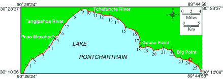 | Figure: 7 Location of shore-normal transects for Northern Lake Pontchartrain. | Table 3: Shoreline Movement in Meters | | Transect | 1850-1995 | Rate
(m/yr) | 1930-1995 | Rate
(m/yr) | 1960-1995 | Rate
(m/yr) | | 1 | -195 | -1.3 | -140 | -2.2 | -37 | -1.1 | | 2 | -210 | -1.4 | -137 | -2.1 | -75 | -2.1 | | 3 | -275 | -1.9 | -153 | -2.4 | -85 | -2.4 | | 4 | -523 | -3.6 | -287 | -4.4 | -181 | -5.2 | | 5 | -393 | -2.7 | -210 | -3.2 | -110 | -3.1 | | 6 | -232 | -1.6 | -177 | -2.7 | -193 | -5.5 | | 7 | -154 | -1.1 | -158 | -2.4 | -120 | -3.4 | | 8 | -97 | -0.7 | -45 | -0.7 | -47 | -1.3 | | 9 | -82 | -0.6 | -98 | -1.5 | 25 | 0.7 | | 10 | -344 | -2.4 | -238 | -3.7 | 0 | 0.0 | | 11 | -210 | -1.4 | -218 | -3.4 | 45 | 1.3 | | 12 | -152 | -1.0 | -95 | -1.5 | -90 | -2.6 | | 13 | 5 | 0.0 | -31 | -0.5 | 5 | 0.1 | | 14 | -14 | -0.1 | -65 | -1.0 | 38 | 1.1 | | 15 | -147 | -1.0 | -210 | -3.2 | -32 | -0.9 | | 16 | -65 | -0.4 | -140 | -2.2 | -15 | -0.4 | | 17 | -74 | -0.5 | -82 | -1.3 | 5 | 0.1 | | 18 | -284 | -2.0 | -163 | -2.5 | -27 | -0.8 | | 19 | -211 | -1.5 | -84 | -1.3 | -34 | -1.0 | | 20 | -277 | -1.9 | -62 | -1.0 | -36 | -1.0 | | 21 | -158 | -1.1 | -112 | -1.7 | 0 | 0.0 | | 22 | -129 | -0.9 | -145 | -2.2 | -22 | -0.6 | | 23 | -66 | -0.5 | 9 | 0.1 | -39 | -1.1 | | 24 | -65 | -0.4 | 9 | 0.1 | 17 | 0.5 | | 25 | -169 | -1.2 | -55 | -0.8 | -32 | -0.9 | | | Table 3: Measured change of shoreline position (m) along Northern Lake Pontchartrain for three time intervals and the corresponding shoreline movement rate (m/yr) for each transect. | Table 4: Average Shoreline
Movement in (m/yr) for Northern Lake Pontchartrain. | | 1850-1995 | -1.25 | | 1930-1995 | -1.90 | | 1960-1995 | -1.19 | | « Previous | Next » |
