| |  |  | | Lake Pontchartrain Atlas: | | | | | | | | | | | | | | | | | | | | | | | | | | | | | | | Environmental Issues |  | | | | | | | | | | | | | |  | | | | | | | | | | |  | Environmental Issues - Shoreline Change and Shoreline Change Rates Contributors: Zganjar, Frierson, Westphal, McCarty, Bridges, Penland | Figure 5: 1899 vs. 1995 | 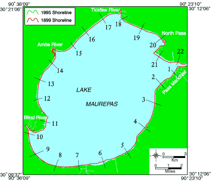 | Figure 5: Locations of shore-normal transects for Lake Maurepas | Table 1: Shoreline Movement in Meters | | Transect | 1899-1995 | Rate
(m/yr) | 1930-1995 | Rate
(m/yr) | 1960-1995 | Rate
(m/yr) | | 1 | -45 | -0.5 | -71 | -1.1 | -22 | -0.6 | | 2 | -59 | -0.6 | -104 | -1.6 | -8 | -0.2 | | 3 | -111 | -1.2 | -75 | -1.2 | -64 | -1.8 | | 4 | -121 | -1.3 | -164 | -2.5 | -73 | -2.1 | | 5 | -65 | -0.7 | -34 | -0.5 | -28 | -0.8 | | 6 | -270 | -2.8 | -158 | -2.4 | -114 | -3.3 | | 7 | -31 | -0.3 | -50 | -0.8 | -7 | -0.2 | | 8 | 3 | 0.0 | 13 | 0.2 | 56 | 1.6 | | 9 | -26 | -0.3 | 26 | 0.4 | 37 | 1.1 | | 10 | -21 | -0.2 | 133 | 2.0 | 6 | 0.2 | | 11 | -134 | -1.4 | -21 | -0.3 | -25 | -0.7 | | 12 | -99 | -1.0 | 85 | 1.3 | -18 | -0.5 | | 13 | -30 | -0.3 | 12 | 0.2 | -8 | -0.2 | | 14 | -81 | -0.8 | 51 | 0.8 | -7 | -0.2 | | 15 | -131 | -1.4 | -47 | -0.7 | 0 | 0.0 | | 16 | -216 | -2.3 | -107 | -1.6 | -102 | -2.9 | | 17 | -164 | -1.7 | -18 | -0.3 | -61 | -1.7 | | 18 | -66 | -0.7 | -86 | -1.3 | -40 | -1.1 | | 19 | -97 | -1.0 | -51 | -0.8 | -19 | -0.5 | | 20 | -33 | -0.3 | -58 | -0.9 | -40 | -1.1 | | 21 | -181 | -1.9 | -114 | -1.8 | -49 | -1.4 | | 22 | -68 | -0.7 | -26 | -0.4 | -23 | -0.7 | | | Table1: Measured change of shoreline position (m) along Lake Maurepas for three time intervals and the corresponding shoreline movement rate (m/yr) for each transect. | Table 2: Average Shoreline
Movement in (m/yr) for Lake Maurepas. | | 1899-1995 | -0.96 | | 1930-1995 | -0.60 | | 1960-1995 | -0.79 | | « Previous | Next » |
