|
|
By Scott T. Prinos |
|

|
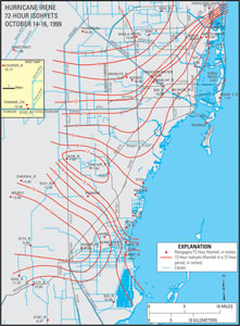
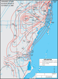
INTRODUCTIONDescription of Study AreaMiami-Dade County encompasses an area of about 2,000 mi2 in southern Florida, with urbanization concentrated in the eastern part of the county and Everglades National Park and the water-conservations areas comprising the western part (fig. 2). Miami-Dade County generally receives about 57 in. of rain annually (Ali and Abtew, 1999), and historically drainage has been relatively slow. Rainfall in Miami-Dade County varies spatially and seasonally. About 70 percent of the annual rainfall occurs during the wet season from June to October. Tropical storms and hurricanes produce intense rainfall in short periods and can represent a very large portion of a given year's rainfall total. The extent of spatial variation in rainfall from Hurricane Irene and an unnamed storm are illustrated in figure 3. While rainfall from Hurricane Irene (fig. 3A) varied spatially from about 7 to 16 in., rainfall from the unnamed storm (fig. 3B) varied from about 6 to 18 in. As evidenced, the amount of rainfall from the unnamed storm that occurred in a small portion of north-central Miami-Dade County in a 2-day period (fig. 3B) was equivalent to about 30 percent of the average annual rainfall.
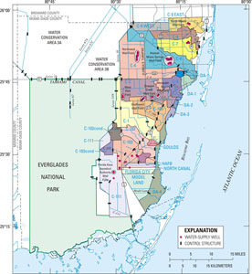
The Biscayne aquifer is the primary source of municipal water supply in Miami-Dade County (Marella, 1999). This aquifer is unconfined and is up to 160 ft thick. It is thickest in northeastern Miami-Dade County and thins to the south and west. In extreme northwestern Miami-Dade County, the Biscayne aquifer is not present (Fish and Stewart, 1991). Transmissivities are about 1,000,000 ft2/d throughout much of Miami-Dade County where the highly permeable Biscayne aquifer is present, but can be as great as 2,900,000 ft2/d in some other parts of the county (Fish and Stewart, 1991). Water from direct infiltration of precipitation, seepage from canals, and water from the conservation areas and Everglades recharges the Biscayne aquifer. The population in Miami-Dade County has increased dramatically since the USGS began cooperatively monitoring ground-water levels in this area. Between 1940 and 1995, the population in Miami-Dade County increased from 267,739 (Parker and others, 1955) to about 2,013,821 (Marella, 1999). During this same period, ground-water usage in Miami-Dade County increased from a maximum of 33 Mgal/d to an estimated 386.60 Mgal/d, including exports of water to other counties (Parker and others, 1955; Marella, 1999). Increased urbanization of Miami-Dade County required a complex water-supply and water-management system that can be used to provide flood protection, retard saltwater encroachment, and meet the water needs of the public and delicate ecosystems. Numerous canals, water-control structures, and public-supply wells have been added since 1939. These changes have affected the movement of surface water and ground water in the county. The water-supply and water-management systems extend throughout much of the county, and are particularly complex in urbanized eastern Miami-Dade County (fig. 2). The flow of surface water in Miami-Dade County is managed using an extensive canal system that is regulated by way of about 76 water-control structures along the major canals (and many additional structures along minor canals). Based on the network of canals and structures, 25 drainage basins have been delineated in Miami-Dade County (fig. 2). There are 18 municipal well fields in eastern Miami-Dade County. The largest well fields are the Alexander Orr, Florida Keys Aqueduct Authority, Hialeah-Miami Springs, Northwest, Snapper Creek, Southwest, and West Well Fields (fig. 2). A relatively large portion of the current ground-water level monitoring network (21 of 98 wells) is dedicated to monitoring the West Well Field, which is only about 1.5 mi east of Everglades National Park. Monitoring activities at 11 of the 21 monitoring wells in this area were specifically required in October 1993 as part of an agreement between the U.S. Department of the Interior, the Governor of Florida, Miami-Dade County, and the South Florida Water Management District (Lisbeth Britt, Department of Environmental Resource Management, Miami-Dade County, written commun., 2003). Using this management system, water from Lake Okeechobee and the water-conservation areas can be directed as needed. Some of the required needs for water include providing recharge to the Biscayne aquifer near municipal well fields, maintaining water levels in the aquifer and canals near the coast to prevent saltwater encroachment, and maintaining the historic hydroperiods in the Everglades. This system also can be used to rapidly lower water levels in Miami-Dade County in advance of impending severe rainfall events to reduce the risk of flooding. Salinity control structures near the coast have been installed to reduce the landward migration of seawater in canals during periods of low canal flow. Next: Previous Studies |
| |||||||||||||||||||||||||||||||||||||