|
|
Introduction
Setting
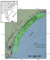 |
Figure 1. Location map of the study area showing geophysical tracklines and surficial grab sample locations.
Click on figure for larger image and full caption.
|
Long Bay is a large arcuate embayment that lies along the northeastern South Carolina coast, bound to the north and south by the Cape Fear and Santee Delta/Cape Romaine shoal complexes, respectively (fig. 1). This study focuses on the Grand Strand, a 100-km stretch of coastline within the apex of Long Bay that extends from Little River Inlet in the north to the mouth of Winyah Bay estuary in the south. This area of mainland coast is characterized by few barrier islands and associated tidal inlets, except at its northern and southern extents.
Presently, little modern fluvial sediment enters the Grand Strand region (Hayes, 1994; Patchineelam and others, 1999). To the south, the Pee Dee River system and its tributaries drain the Piedmont and coastal plain to the Winyah Bay estuary. Patchineelam and others (1999) and Hayes (1994) suggest that placement of dams along the Pee Dee River and trapping of fine-grained sediment within the bay and adjacent salt marshes severely restrict sediment input into the littoral system. The contribution of sediment from Winyah Bay to the study area is further limited by a southerly long-shore current, as evidenced by southerly spit growth at the entrance of Winyah Bay (Hayes, 1994; Gayes and others, 2003). North of the Grand Strand, the Cape Fear River enters Long Bay. However, the Cape Fear shoal complexes and spits appear to be efficient sediment sinks, limiting fluvial input from the Cape Fear River system to the southern portions of Long Bay (Denison, 1998; Patchineelam and others, 1999).
Long Bay is characterized as a mixed-energy environment, more heavily dominated by waves than tides. Tidal ranges are < 2 meters, and mean wave heights range between 1.2 to 1.3 meters (Hayes and others, 1993; Hayes, 1994). Long Bay represents a transition zone between the wave-dominated, microtidal North Carolina barrier-island coast to the tidally controlled, mesotidal barrier coast of southern South Carolina and Georgia (Brown, 1977; Hayes and others, 1993; Hayes, 1994).
Winds within Long Bay vary somewhat seasonally, but yearly averages show that winds generally align with the southwest/northeast orientation of the coast (Brown, 1977; Blanton and others, 1985). During the winter, spring, and summer, northeast and southwest winds generally prevail, with north/northeast winds dominating in the fall.
|

 Back to Previous Section
 Forward to Next Section