U.S. Geological Survey Open-File Report 2008-1206
Coastal Change Along the Shore of Northeastern South Carolina: The South Carolina Coastal Erosion Study
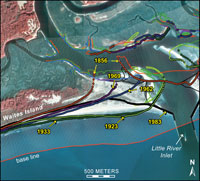
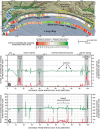
4.2 Beaches on the MoveShoreline change over different time scales is quantified by comparing a series of maps, aerial photographs, or physical surveys made months, years, or decades apart (Figure 4.1). The measured "shoreline" has been variously defined as a specific contour elevation (that is, mean high water), a wet-dry line visible on aerial photographs, or a surveyed crest of the primary dune. Lateral movement of a shoreline over a specified period of time is typically shown as a series of colored-coded lines on a map (Figure 4.2A). Maps of this type reduce a complex coastal system to a single line when, in fact, the active beach covers a broad zone that extends a distance both landward and seaward of the shoreline. Accurate data are difficult to collect from submerged parts of the beach system where waves and currents are energetic. Most land-based surveying techniques end in shallow wading depths of about 1.5 m (5 ft), and marine-based surveys stay well offshore of the surf zone where ships can safely navigate. As a result, considerable areas of the active beach are poorly represented in most coastal erosion studies. Early studies typically provided only long-term trends because they relied on sparse data generated over many years. Beach profiles were collected more often, usually once or twice per year, but localized areas of high erosion rates commonly went undetected due to the wide spacing between profiles. Rates of shoreline change have varied widely along the Grand Strand since the middle of the 19th century (Hubbard and others, 1977a, 1977b; Anders and others, 1990; Morton and Miller, 2005). To quantify these changes better, the SCCES compiled several sources of data into a geographic information system (GIS). Paper maps originally produced by Anders and others (1990) were digitized and rectified to provide shoreline positions from 1851 to 1983. Shorelines determined from annual airborne topographic surveys (see section 2) between 1996 and 2000 were provided by NOAA. Shoreline-change rates were calculated over two time scales, historical and short term (Figure 4.2). Mainland-attached beaches have remained relatively stable, with rates of retreat generally less than 0.5 m/yr (1.6 ft/yr). Barrier islands, however, have undergone large shifts in shoreline position, especially deposits in the vicinity of tidal inlets because they commonly migrate along the coast in response to longshore currents. Inlet migration causes alternating periods of accretion and erosion on the ends of adjacent barrier islands. In addition, new inlets have opened and old inlets have closed over time. Segments of shoreline adjacent to large inlets (North, Murrells, and Little River Inlets) have changed the most, moving landward and seaward at rates up to 10 m/yr (33 ft/yr) since the 1850s. Because of this dynamic behavior, construction and other activities planned adjacent to inlets are managed differently by the State than activities in areas not influenced by inlets (Box #3). Next Section: 4.3 Monitoring South Carolina's Beaches » |

 U.S. Department of the Interior |
U.S. Geological Survey
U.S. Department of the Interior |
U.S. Geological Survey
[an error occurred while processing this directive]
URL: https://pubsdata.usgs.gov
Page Contact Information: Publishing Service Center
Page Last Modified: Wednesday, 07-Dec-2016 21:38:55 EST