U.S. Geological Survey Open-File Report 2008-1206
Coastal Change Along the Shore of Northeastern South Carolina: The South Carolina Coastal Erosion Study
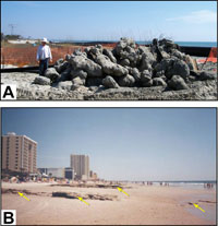
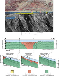
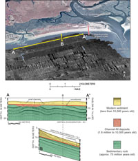
4.4 Framework Controls on BeachesGrand Strand beaches sit on top of a framework of layered sedimentary rocks, which have been deeply eroded over the last few million years (see section 3). The upper surface of those units is widely exposed on the shoreface and inner shelf, especially offshore of mainland-attached beaches in the central part of the study area. The erosion-resistant materials lie at shallow depths beneath the regions' beaches (Figure 4.4a) and provide firm foundations for high-rise buildings. Outcrops of cemented beach deposits are also sporadically exposed and buried by movement of modern beach sands at Hurl Rocks Park in Myrtle Beach (Figure 4.4b). Near tidal inlets in the northern and southern parts of the Grand Strand, however, thicker deposits of modern sediment completely bury the rocks. The shoreface profile and stability of beaches over time are very different where sediment is abundant, such as Waites Island, relative to areas where sediment is scarce, such as Myrtle Beach. The following sections describe representative examples of sediment-limited and sediment-rich areas of the Grand Strand. In these two examples, the relative abundance of modern sediment on the shoreface determines the overall shape of adjacent beaches and local rates of coastal erosion. Central Grand Strand: Sediment-Limited Framework The central part of the Grand Strand, occupied in part by the City of Myrtle Beach, is one of the longest stretches of the U.S. eastern seaboard that is not protected by barrier islands. For a distance of more than 50 km (31 mi), open-ocean processes act directly on the mainland. Landward of the beaches, adjacent upland elevations rise quickly to more than 10 m (33 ft) above local mean sea level, putting most of the city above the flood zone. Average rates of shoreline change in this area are relatively low, except around swashes where the shoreline is migrating across small fluvial valleys that drain the adjacent upland (Figure 4.2). The relative stability of the Myrtle Beach coastline is largely controlled by sedimentary rock and erosion-resistant deposits of ancient shorelines that underlie the area. The central Grand Strand area represents an end-member example where older sedimentary rocks dominate the shoreface. Offshore of Myrtle Beach, the shoreface is characterized by a series of low-relief scarps and ledges formed by layers of rock exposed at the seafloor. Subbottom profiles collected along the beach just seaward of the surf zone show that rocks also compose the shallow subsurface (Figure 4.5). The shape and position of the beach and shoreface change relatively little in areas where modern processes act on these erosion-resistant deposits. This area has exhibited only modest changes in beach profile during large erosional events such as Hurricane Hugo in 1989 (Nelson, 1991) and during the years following such storms (Figure 2.8). The most significant change resulted from a regional beach-nourishment project in 1997 that pumped large amounts of sediment from borrow sites offshore onto the beach. At that time (prior to the SCCES), little information on the location and volume of offshore sediment resources was available to guide dredge operations. Instead of hitting soft sediment, dredges often scraped rocky parts of the seafloor even though large deposits of high-quality sand existed nearby. Low-relief rocky outcrops do not characterize the entire shoreface of the central Grand Strand. In some areas, the cross-shore beach profile is much smoother and steeper than in adjacent rocky areas; the smooth profiles coincide with the locations of ancient river channels eroded into older sedimentary rocks (Figure 4.5C). Deposits filling the channels are younger, relatively weaker, and therefore less resistant to erosion than sedimentary rock. The smooth, steeply sloping shoreface reflects the relative ease by which channel-fill deposits can be eroded by waves and currents. Northern Grand Strand: Sediment-Rich Framework At the northern and southern ends of the coastal system, barrier islands have formed instead of the mainland-attached beaches that characterize the central part of the Grand Strand. Waites Island, located at the northern end (Figure 4.2), is the first in a chain of small barrier islands that extend north along the coast of Long Bay to Cape Fear, NC. Sandy barriers of similar shape and size also extend south from Garden City to Winyah Bay. As is typical for barrier islands, their shape and behavior are strongly influenced by waves hitting the beach and tidal currents moving in and out of inlets. Unlike areas closer to the center of the Grand Strand, the shoreface and inner shelf along Waites Island contain abundant sand. Erosion-resistant sedimentary rocks are more deeply buried by Holocene sediment at this location (Figure 4.6). The shape and position of the shoreline are strongly modified by storage of modern sediment in tidal shoals associated with Little River and Hog Inlets. The inlet-related sand bodies are up to 6 m (20 ft) thick and together represent one of the largest accumulations of modern sediment along the coast. The shoreface along Waites Island generally forms a smooth concave-up profile, the characteristic shape of beaches with abundant mobile sediment (Figure 4.3b). For most of the island, significant amounts of sediment have accumulated in the upper beach system. Beach ridges have expanded seaward over the last 20 years, probably because of jetty construction at Little River Inlet. Sediment captured by the jetties has accumulated along the north end of the island. The mid-to-lower shoreface, however, has not grown seaward in the same way as the upper beach. Measured at a depth of 5 m, the shoreface has progressively migrated landward, thereby creating a steeper slope over time. Next Section: 4.5 Exposure and Burial of Hardbottom Areas » |

 U.S. Department of the Interior |
U.S. Geological Survey
U.S. Department of the Interior |
U.S. Geological Survey
[an error occurred while processing this directive]
URL: https://pubsdata.usgs.gov
Page Contact Information: Publishing Service Center
Page Last Modified: Wednesday, 07-Dec-2016 21:38:56 EST