U.S. Geological Survey Open-File Report 2008-1206
Coastal Change Along the Shore of Northeastern South Carolina: The South Carolina Coastal Erosion Study
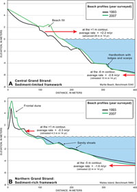
4.3 Monitoring South Carolina's BeachesIn 1993 the USGS, OCRM, and the SC Sea Grant Consortium formed a cooperative program to survey beaches statewide. The program, named Project BERM (Beach Erosion Research and Monitoring), has developed new methods to document change across the entire active beach (see section 2.3). Frequent surveys (up to four times per year at selected locations) have revealed short-term fluctuations in beach shape that aid in constructing a record of seasonal and chronic changes. The ongoing program has continued to characterize the coast on a regional scale through at least 2008. More information on shoreline change can be found at the BERM project website http://www.coastal.edu/cmws/berm/. Beach profiles vary in shape along the length of the Grand Strand, largely depending on the volume of sediment available in a particular location. Beaches with little sediment exhibit steeper, more irregular profiles relative to beaches with abundant sediment. Representative profiles at two sites were chosen to illustrate the differences in profile shape: Average rates of shoreline retreat from the 1850s to the 1980s are 0.2 m/yr (0.7 ft/yr) at the site of the Myrtle Beach profile, and 0.9 m/yr (3 ft/yr) at the Waites Island profile (Figure 4.2). Even though long-term shoreline movement has been relatively slow, profiles collected 14 years apart show that more rapid changes are occurring in shallow submerged areas adjacent to the beach (Figure 4.3). The lower shoreface at Myrtle Beach, measured at the 6-m depth contour, has migrated landward at an average rate of 0.8 m/yr (2.6 ft/yr). At Waites Island, the 5-m depth contour has migrated landward at an average rate of 2.3 m/yr (7.6 ft/yr). As a result, nearshore water depths at these locations are slowly increasing and beach profiles are becoming steeper over time. Steepening at Myrtle Beach can be attributed to beach nourishment pushing the upper profile seaward and erosion driving landward migration of the lower shoreface, albeit slowed by the presence of hard rocky substrate. The cause of steepening at Waites Island is not known, but might be related to sediment trapping by jetties at Little River Inlet. Whatever the cause, as water depths in front of a beach increase, wave impacts on the shoreline also increase. Next Section: 4.4 Framework Controls on Beaches » |

 U.S. Department of the Interior |
U.S. Geological Survey
U.S. Department of the Interior |
U.S. Geological Survey
URL: https://pubsdata.usgs.gov/pubs/of/2008/1206/html/change3.html
Page Contact Information: Publishing Service Center
Page Last Modified: Monday, 03-Jun-2019 11:36:30 EDT