U.S. Geological Survey Open-File Report 2010-1332
GLORIA Sidescan-Sonar Imagery for Parts of the U.S. Exclusive Economic Zone and Adjacent Areas
Digital Processing
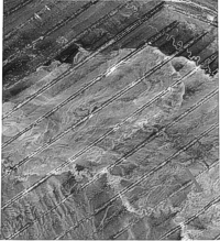
The imagery contained in the GLORIA mosaics are assembled from digitally collected, computer processed sidescan sonographs. The sonographs, or swaths, were recorded digitally on 9-track magnetic tapes in 6-hour-long files (considered the raw data) and generally referred to as "passes" (fig. 8). The passes were processed individually through a standard set of processing programs to correct for geometric and radiometric distortions that exist in the raw data. The software, written specifically to correct both the geometric and radiometric distortions were part of an operational software package referred to as the U.S. Geological Survey's Mini Image Processing System (MIPS) (Chavez, 1984). During the several years of data collection and processing, the computer programs and processing steps were refined though the processing remained essentially standardized, thus keeping the data quality consistent despite the large number of personnel working on the program over the years. The computer programs focused on GLORIA-specific algorithms that included corrections for slant-range geometry, water-column offset, aspect ratio distortion, ship's velocity changes, speckle noise, and shading due to signal drop off as a function of range. Classification of the computer programs used in the initial processing of the raw data are grouped in two categories. The first set of programs were used to correct for geometric distortions in the dataset that are a result of the way the data are collected. The result of these programs were to move the pixels and put them in their proper across- and along-track location. The second group of programs were to apply radiometric corrections to improve the quality of the collected data. The result of these programs were to modify the pixel values. (Condit, 1979) A brief description of the major processing steps follows. The descriptions have been grouped within the two categories (geometric or radiometric corrections) for simplicity of the discussion. In actuality, the processing sequence for a 6-hour-long pass mixes the sequence of the geometric and radiometric corrections. A typical processing sequence may be examined with this flowchart (fig. 7). Geometric distortions and their correction may be summarized as:
Radiometric corrections applied may be summarized as:
Digital MosaickingAfter the sidescan-sonar swaths were processed to correct them geometrically and radiometrically, they were ready for digital mosaicking. Initially the final results of the digital mosaicking steps were to create mosaics of a 2-degree by 2-degree area. However in some areas, such as the Alaska regions, mosaics of a 3-degree by 2-degree area were created. Digital mosaicking of the GLORIA data is more difficult than that of other image data because geometric control is available only at nadir (Chavez and others, 1996). The mosaicking procedure involves several steps. To begin, the swaths needed to create a straight line segment for a given map area must be identified. This was done by referencing the survey track map and the processed GLORIA data to match the dates and times of the necessary segments. Multiple 6-hour-long passes were spliced end-to-end to make a continuous line segment that passed through the intended mosaic area and where the portions of the ship's heading remained generally constant. If necessary, the swaths were tone matched by applying a contrast stretch to minimize the seam where they were joined. Four control points were then selected as nadir references from the newly created strips. The first and fourth control points reflected the start and end of the line segment while the second and third control points were selected to be spaced evenly within the swath. From these four points a trigometric computation was made to produce an additional eight control points that would tie the edge of the image to the map space. With these twelve control points, the strip was georeferenced within the map area. This step was repeated for each strip of sonar data for each specific area (fig. 13). After all the swaths for a given map area were georeferenced, the adjacent lines segments were stenciled together to create a continuous mosaic. In cases where further registration of the strips was required to align seafloor features, additional ground control points and rubber sheeting was done prior to the stenciling. When the swaths were aligned, interactive stenciling of the swaths was done by drawing a polygon around the area of the swath to be retained (fig. 14). The final step is the digital mosaicking procedure. This process of combining several arbitrarily shaped images to form one large, radiometrically-balanced image can be very user intensive. In the case of sidescan-sonar, the images are the adjacent swaths collected during the survey. The mapped swaths are combined together along user-specified cut lines defining the polygon and image precedence (which part of the image to keep; which part of the image to remove). Ideally, the cut-line boundaries can be blended together to reduce the boundary between images so they are not easily seen. The stenciled line segments were then combined sequentially to build the composite map (fig. 15). A more detailed description of the GLORIA digital processing and program details is available from Chavez (1986) and Chavez and others (1996). |