Open-File Report 2014–1018
![]() Title |
List of Figures |
Conversion Factors |
Abstract |
Introduction |
Setting |
Methods |
Bathymetry |
Sidescan Sonar |
Sediments |
Bottom Photography |
GIS Data Catalog |
Summary |
Acknowledgments |
References |
Contacts |
Index
Title |
List of Figures |
Conversion Factors |
Abstract |
Introduction |
Setting |
Methods |
Bathymetry |
Sidescan Sonar |
Sediments |
Bottom Photography |
GIS Data Catalog |
Summary |
Acknowledgments |
References |
Contacts |
Index
 |
||
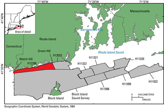
Figure 1. Map showing the location of National Oceanic and Atmospheric Administration (NOAA) survey H12296 (red-shaded polygon) offshore of Rhode Island. Also shown are other NOAA surveys (gray-shaded polygons) that have been interpreted in this series in Rhode Island and Block Island Sounds including H11320 (McMullen and others, 2007), H11321 (McMullen and others, 2008), H11322 (McMullen and others, 2009), H11922 (Poppe and others, 2011), H11995 (McMullen and others, 2012), H11996 (McMullen and others, 2011), H12023 (McMullen and others, 2013) and Block Island Sound survey, a combination of surveys H12009, H12010, H12011, H12015, H12033, H12137, and H12139 (Poppe and others, 2012). |
||

![]() U.S. Department of the Interior |
U.S. Geological Survey
U.S. Department of the Interior |
U.S. Geological Survey
URL: http://pubsdata.usgs.gov/pubs/of/2014/1018/html/fig1.html
Page Contact Information: GS Pubs Web Contact
Page Last Modified: Wednesday, 07-Dec-2016 19:33:51 EST
